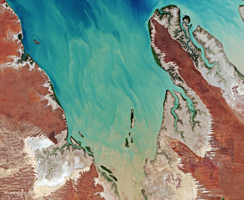
The tiny Valentine Island, visible in the top-left of the image, measures around 1.6 km in length and around 250 m wide. The island is located in the King Sound, a large gulf and inlet of the Indian Ocean in Australia’s Kimberley Region. The gulf is around 120 km long and averages about 50 km in width. Credit: Contains modified Copernicus Sentinel data (2020), processed by ESA, CC BY-SA 3.0 IGO
For Valentine’s Day, the Copernicus Sentinel-2 mission takes us over Valentine Island in northern Western Australia.
The tiny Valentine Island, visible in the top-left of the image, measures around 1.6 km (1 mi) in length and around 250 m (820 ft) wide. The island is located in the King Sound, a large gulf and inlet of the Indian Ocean in Australia’s Kimberley Region. The gulf is around 120 km (75 mi) long and averages about 50 km (30 mi) in width.
The King Sound has one of the highest tides in Australia, and amongst the highest in the world, reaching a maximum tidal round of around 11 to 12 m (36 to 40 ft). The Fitzroy River, one of Australia’s largest watercourses, along with the Lennard, Meda, and Robinson Rivers, empty their muddy and sediment-laden waters into the Sound.
The images below show the result of the floods brought on by heavy rainfall that hit Western Australia in late 2020. The image on the left was captured on November 11, 2020, while the image on the right was taken around a month later, on December 16, 2020.
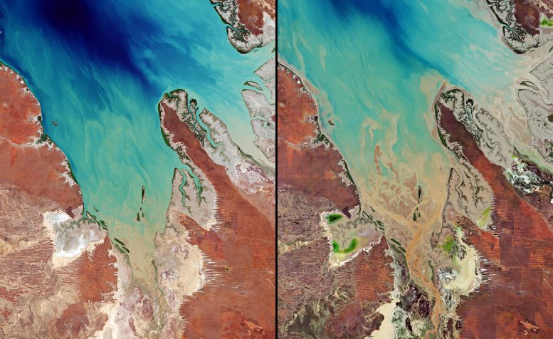
These images captured by the Copernicus Sentinel-2 mission show the result of the floods brought on by heavy rainfall that hit Western Australia in late 2020. The image on the left was captured on November 11, 2020, while the image on the right was taken around a month later, on December 16, 2020. The heavy rain caused a large amount of sediment to be discharged into the King Sound gulf, as seen in dark shades of brown which contrast with the clearer, turquoise-colored waters visible at the top. Credit: Contains modified Copernicus Sentinel data (2020), processed by ESA, CC BY-SA 3.0 IGO
The heavy rain caused a large amount of sediment to be discharged into the Sound, as seen in dark shades of brown which contrast with the clearer, turquoise-colored waters visible at the top. The sediment has also been transported and deposited around Valentine Island.
A myriad of mangrove estuaries can be seen scattered around the coast. Australia is surrounded by around 11,000 km (6,800 mi) of mangrove-lined coast, located primarily on the northern and eastern coasts of the continent. Mangroves contribute many environmental benefits to coastal and estuarine ecosystems; they provide food and habitats for a wealth of wildlife such as birds and fish.
As more people move closer to coastal zones, the risk to mangroves increases. Greater pressure is placed on the mangrove environment from both direct and indirect sources such as dumping of waste, fish farming, sea level rise, and climate change.
Satellite missions such as Copernicus Sentinel-2 allow us to capture spectacular images such as these from space. This year, some of our incredible images of Earth from Space are now available as posters in the ESA On Demand shop. From the Amazon, to the Baltic Sea, to Antarctica, browse our new, Earth-inspired wall art for your home or office. Surprise someone special this Valentine’s Day with the special-edition image of the heart-shaped Moorea Island.
From everyone at ESA’s Earth observation team, we send you all of our love for Valentine’s Day!





Be the first to comment on "Exploring Earth From Space: Valentine Island, Australia"