Greenland’s ice and glacier cover has diminished by 11,000 square miles in three decades due to warming temperatures, leading to significant environmental changes. This transformation has increased vegetation, altered landscapes, and exacerbated climate change effects, highlighting the critical need for climate action.
An estimated 11,000 sq miles or 28,707 sq kilometers of Greenland’s ice sheet and glaciers have melted over the last three decades, according to a major analysis of historic satellite records.
The total area of ice loss is equivalent to the size of Albania, and represents about 1.6 % of Greenland’s total ice and glacier cover.
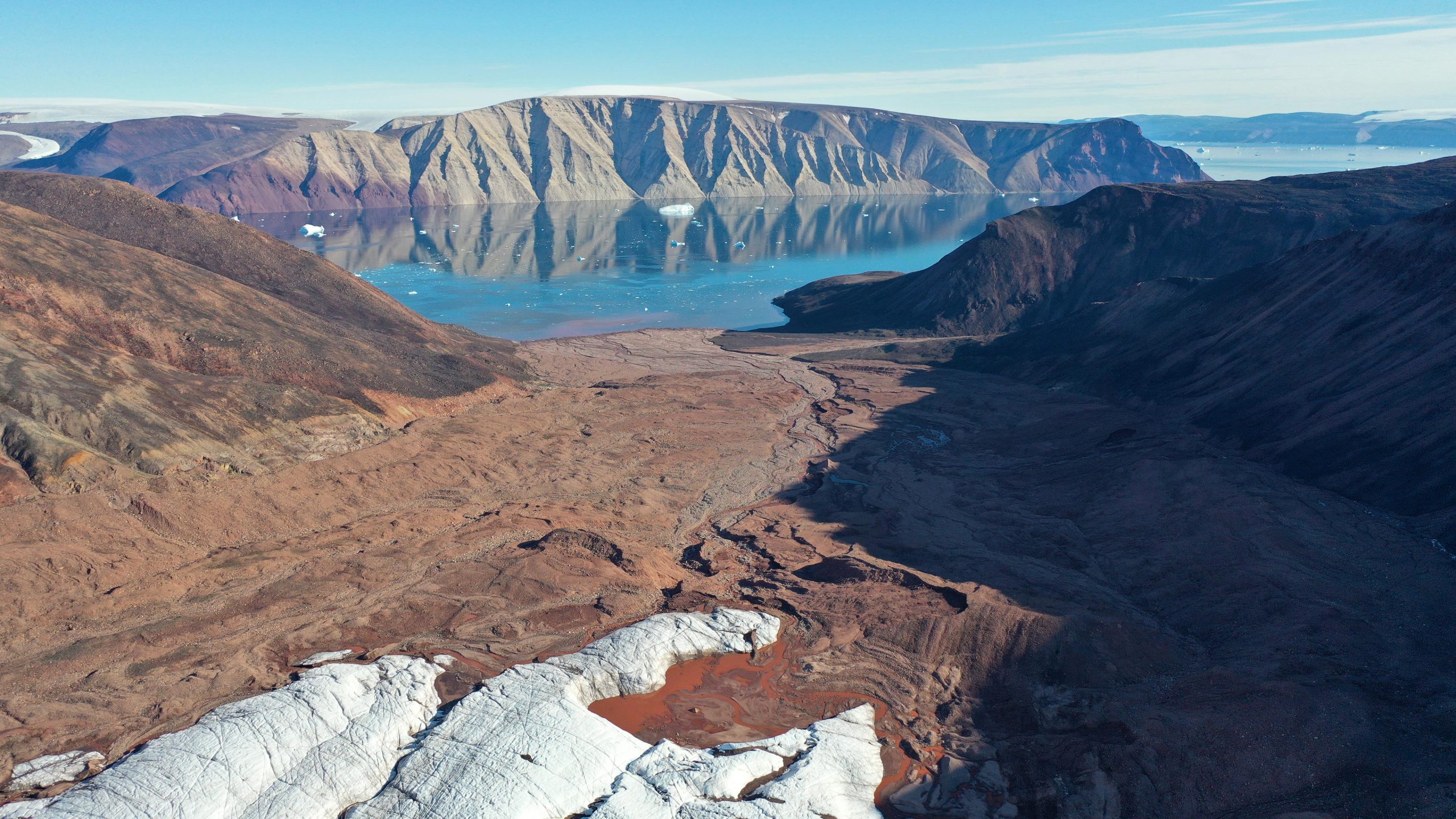
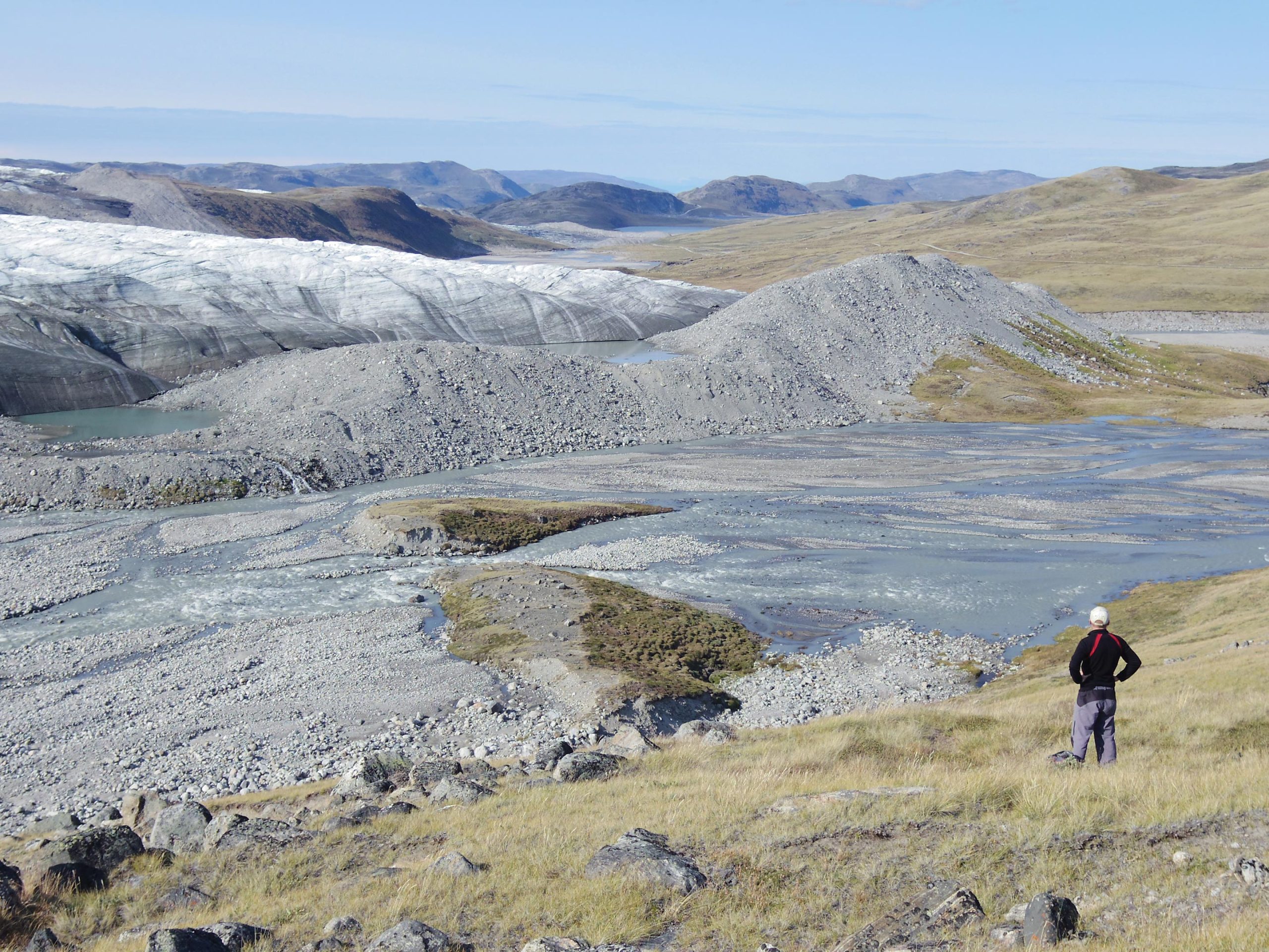
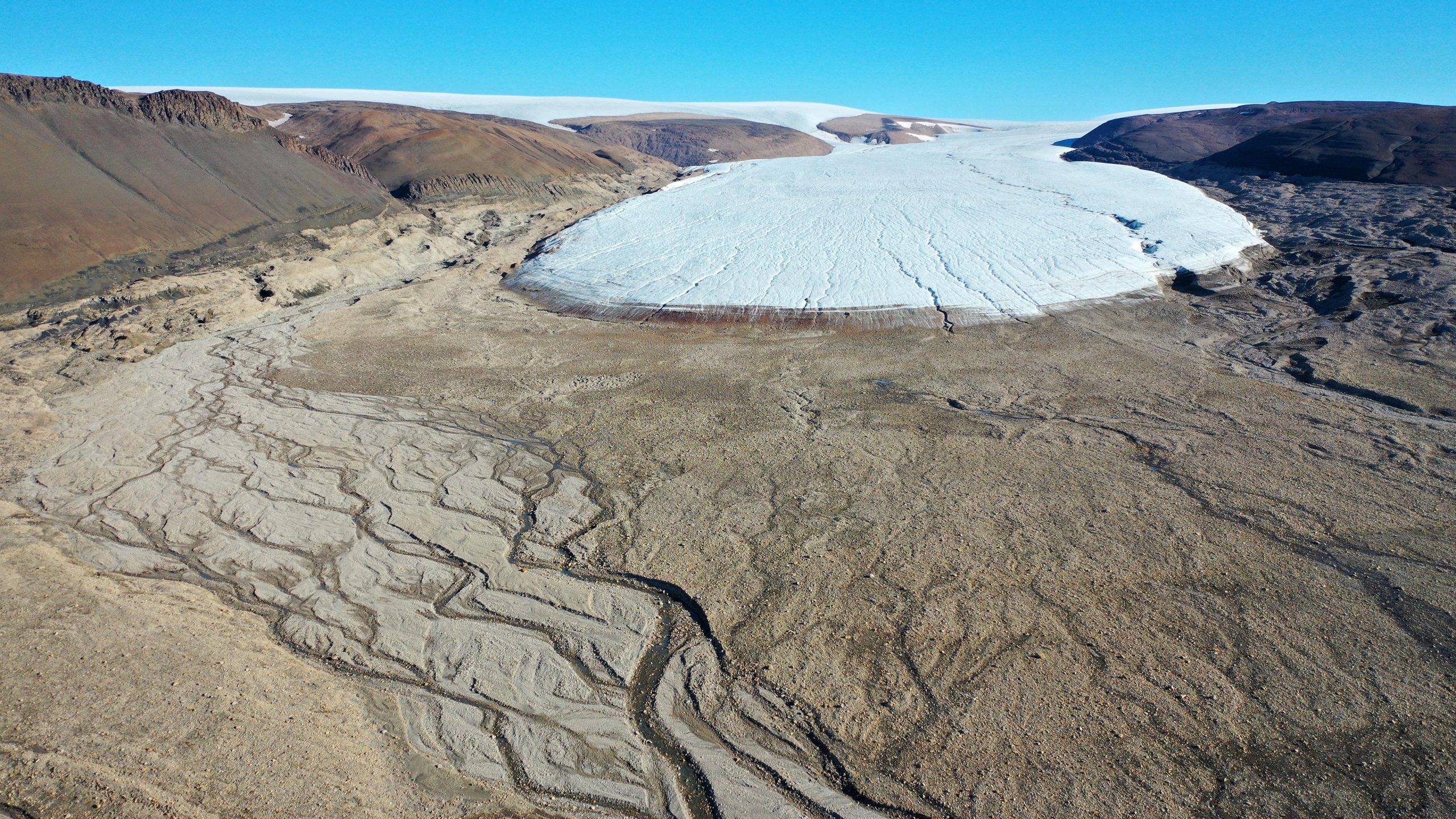
Where there was once ice and snow, there is now barren rock, wetlands, and areas of shrub.
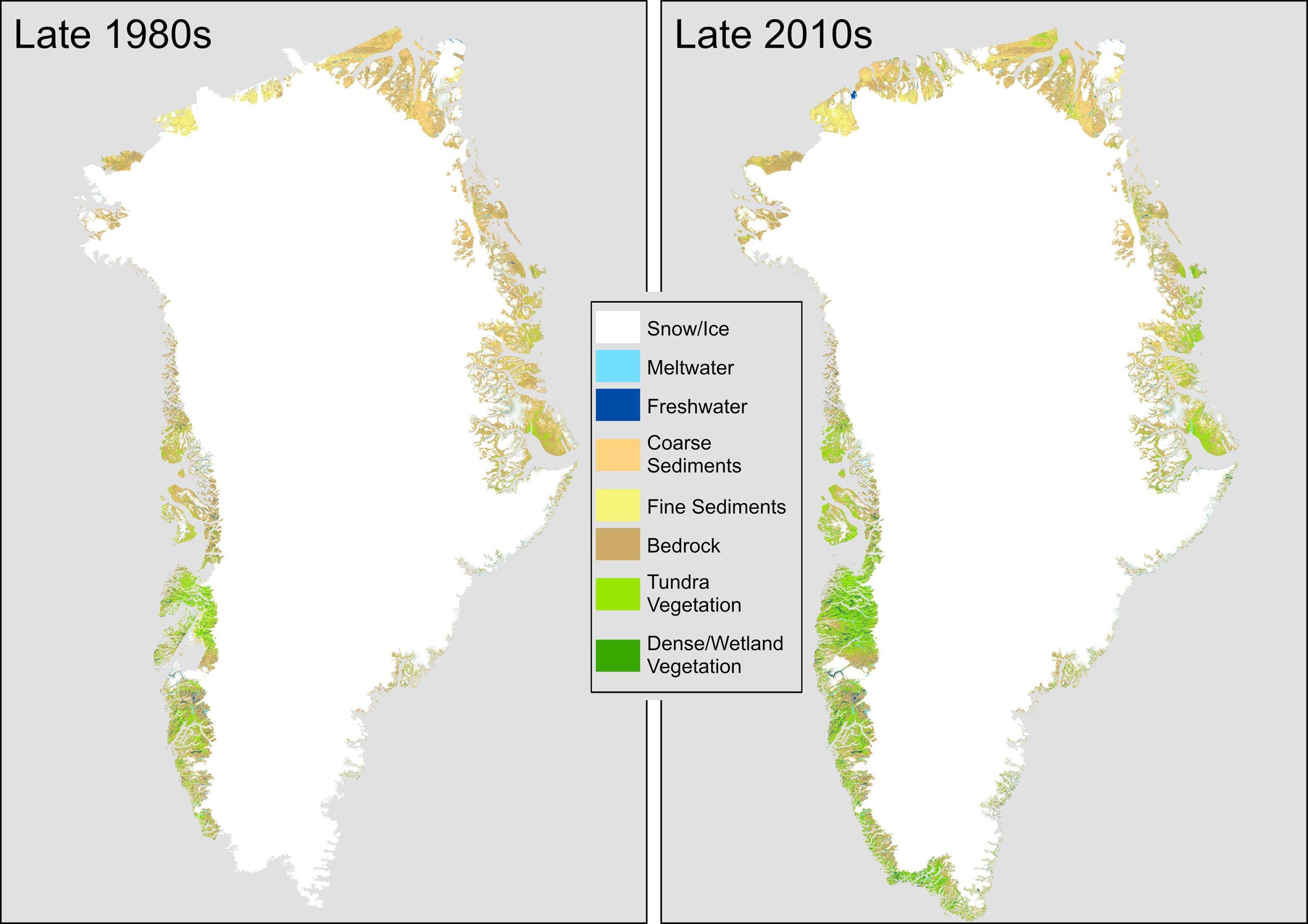
A team of scientists from the University of Leeds, who have tracked the changes across Greenland from the 1980s through to the 2010s, say warmer air temperatures are causing the ice to retreat, which in turn is having an impact on the temperature of the land surface, greenhouse gas emissions and the stability of the landscape.
Permafrost — a permanently frozen layer below the Earth’s surface — is being “degraded” by the warming and in some areas, the scientists warn that it could have an impact on the infrastructure, buildings, and communities that exist above it.
Their findings, “Land cover changes across Greenland dominated by a doubling of vegetation in three decades,” are reported today (February 13) in the journal Scientific Reports.
Warming Trends and Future Predictions
Greenland is part of the Arctic region. It is the world’s biggest island, around 836,330 sq miles in size (2.1 million sq km). Most of the land is covered by ice and glaciers and it is home to almost 57,000 people.
Since the 1970s, the region has been warming at double the global mean rate. On Greenland, average annual air temperatures between 2007 and 2012 were 3 degrees C warmer, compared with the 1979 to 2000 average.
And the researchers warn that more extreme temperatures are likely in the future.
Jonathan Carrivick, an Earth scientist based in the Faculty of Environment at Leeds and one of the authors of the study, said: “Warmer temperatures are linked to the land cover changes that we are seeing on Greenland.
“By analyzing high-resolution satellite images, we have been able to produce a detailed record of the land cover changes that are taking place.”
Ice Disappears To Be Replaced by Bare Rock and Shrubs
Ice loss was concentrated around the edges of present-day glaciers but also in the north and southwest of Greenland. There were also high levels of ice loss in localized areas in the west, mid-north-west and south-east.
Over the three decades, the amount of land with vegetation growing on it increased by 33,774 sq miles (87,475 sq km), more than doubling over the study period.
A pronounced increase in vegetation was seen across the southwest, east, and northeast. The greatest increase in dense wetland vegetation occurred in the vicinity of Kangerlussuaq in the southwest and in isolated areas in the northeast.
Analysis by the researchers revealed that vegetation had increased along a latitudinal gradient between 63 degrees North and 69 degrees North and declined north of this.
Jonathan Carrivick said: “We have seen signs that the loss of ice is triggering other reactions which will result in further loss of ice and further ‘greening’ of Greenland, where shrinking ice exposes bare rock that is then colonized by tundra and eventually shrub.
“At the same time, water released from the melting ice is moving sediment and silt, and that eventually forms wetlands and fenlands.”
Loss of Ice Triggers Further Warming
The loss of ice affects land surface temperatures because of albedo, which is the measure of how reflective a surface is.
Snow and ice are good reflectors of the sun’s energy hitting the Earth’s surface and this helps to keep the Earth cooler. As the ice retreats, it exposes bedrock which absorbs more solar energy, raising the temperature of the land surface.
Similarly, as ice melts it increases the quantity of water in lakes. Water absorbs more solar energy than snow and this also increases the temperature of the land surface.
Greenhouse Gas Emitter
The analysis shows a near quadrupling of wetlands across Greenland, particularly in the east and north-east. The wetlands are a source of methane emissions.
Writing in the paper, the researchers noted: “Expansion of vegetation and especially in wetland areas indicates but also exacerbates permafrost thaw, active layer thickening and thus emissions of greenhouse gases previously stored in these Arctic soils.”
The researchers also developed a model to predict those areas on Greenland that are likely to see “marked and accelerated” change in the future.
Dr. Michael Grimes, the lead author of the report who conducted the research as part of their PhD, added: “The expansion of vegetation, occurring in tandem with the retreat of glaciers and the ice sheet, is significantly altering the flow of sediments and nutrients into coastal waters.
“These changes are critical, particularly for the indigenous populations whose traditional subsistence hunting practices rely on the stability of these delicate ecosystems.
“Moreover, the loss of ice mass in Greenland is a substantial contributor to global sea level rise, a trend that poses significant challenges both now and in the future.”
Reference: “Land cover changes across Greenland dominated by a doubling of vegetation in three decades” by Michael Grimes, Jonathan L. Carrivick, Mark W. Smith and Alexis J. Comber, 13 February 2024, Scientific Reports.
DOI: 10.1038/s41598-024-52124-1
Never miss a breakthrough: Join the SciTechDaily newsletter.
Follow us on Google and Google News.
1 Comment
“Water absorbs more solar energy than snow and this also increases the temperature of the land surface.”
That is generally true at equatorial and mid-latitudes. However, at polar latitudes, the specular reflection off water can exceed the diffuse reflectance of snow. I’m left with the impression that these ‘scientists’ are unfamiliar with optical physics in general, and Fresnel’s Equation in particular. They are extrapolating their experiences with specular reflection where they live, to regions where the behavior is very non-linear.