A new global ice sheet reconstruction for the past 80,000 years.
During ice ages, the global mean sea level falls because large amounts seawater are stored in the form of huge continental glaciers. Until now, mathematical models of the last ice age could not reconcile the height of the sea level and the thickness of the glacier masses: the so-called Missing Ice Problem. With new calculations that take into account crustal, gravitational, and rotational perturbation of the solid Earth, an international team of climate researchers has succeeded in resolving the discrepancy, among them Dr. Paolo Stocchi from the Royal Netherlands Institute for Sea Research (NIOZ).
The study, now published in the journal Nature Communications, could significantly advance research into the climate of the past and help to make better sea-level predictions for the future.
Paolo Stocchi: “Our new reconstruction revolutionizes what we thought about the global continental ice mass during the Last Ice Age. The total mass of the Last Ice Age glaciers was 20% smaller and accumulated faster than previously thought.”
Growing and melting glaciers
With the alternation of ice ages and warm ages, the glaciers in Greenland, North America, and Europe grow and shrink over the course of tens of thousands of years. The more water is stored in the form of ice, the less water there is in the oceans — and the lower the sea level. Climate researchers want to find out how much the glaciers could melt in the course of man-made climate change in the next centuries and how much the sea level will rise as a result. To do this, they look into the past. If one succeeds in understanding the growth and melting of the glaciers during the last ice and warm periods, then conclusions can be drawn for the future.
The “problem of the missing ice”
But this look into the past is difficult because the thickness of the glaciers and the height of the sea level can no longer be measured directly in retrospect. Climate researchers therefore have to laboriously collect clues that can be used to reconstruct the past. However, depending on which clues you collect, the results are different and seem to contradict one another. Previous models and calculations led to the so-called “missing ice” riddle.
Geological evidence from ocean areas suggests that sea level might have been 120-140 m lower than today during the last Ice Age 20,000 years ago. The uncertainty of these data is quite large, though. To account for these low sea levels, as much as twice the current mass of the Greenland ice sheet would have to have been frozen worldwide. However, these glacier masses could not possibly have been that large at the time, according to climate models. Also, there is no geological evidence at higher latitudes for such a large mass of ice.
How to explain then that the water wasn’t in the sea and at the same time it wasn’t stored in the freezer on land either?
80,000 years of ice sheets and sea-level changes accurately reconstructed
This problem has now been solved with a new method by an international team of scientists led by Dr. Evan Gowan (Alfred-Wegener-Institut, Helmholtz-Zentrum für Polar- und Meeresforschung, in Bremerhaven). Among them is the geophysicist Dr. Paolo Stocchi from The Royal Netherlands Institute for Sea Research.
“We have found a way to accurately reconstruct the last 80,000 years of ice sheets and sea-level changes,” says Dr. Paolo Stocchi, who has contributed to the creation of the novel global ice sheet model by including crustal, gravitational, and rotational perturbation of the solid Earth.
Their new model explains past local sea levels that are lower than today by incorporating the relative motion of the sea surface and Earth’s crust. In this way, past local sea levels that are much lower than today, can be modeled without requiring an unrealistically large global ice mass. The solid Earth motions would do the trick!

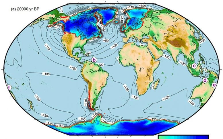
illustration: Reconstructed paleotopography, ice sheets thickness, and margins at the Last Glacial Maximum (20,000 years ago) (https://doi.pangaea.de/10.1594/PANGAEA.905800). Credit: AWI
Understanding the behavior of glaciers by looking at the Earth’s mantle
With the new method, the scientists have eventually reconciled sea level and glacier mass: According to their calculations, the sea level must have been around 116 meters lower than today at the time. There is no discrepancy in terms of glacier mass.
Unlike the previous global model, the team took a closer look at the geological conditions in the proximity and underneath the formerly glaciated areas, and not in the far-field ocean areas: How steep were the mountain slopes? Where did glaciers reach the sea? Did friction interfere with ice flow velocity? And how much? The new model includes all these local factors. It also accounts for ice- and water-load-induced crustal deformations. The latter are important because they alter the topography of the land, thus affecting the ice flow and eventually the volume of glaciers.
“Crustal deformations are regulated by solid Earth physical parameters such as viscosity,” says Paolo Stocchi. The Earth’s mantle, in fact, behaves like a highly viscous fluid on geological time scales and deforms under the weight of a fluctuating ice mass. “By assuming different viscosities of the earth’s mantle, we model different evolutions of the land topography, which then result in different scenarios for the ice masses.” These can now be brought into harmony with the marine geological evidence from the ocean areas, without the need for extra mass.
The established isotope model needs to be revised
The technical article by Evan Gowan and his team takes a critical look at the method for estimating glacier masses that has been the standard in science for many years: the method of measuring oxygen isotopes. Isotopes are atoms of the same element that differ in the number of their neutrons and therefore have different weights. For example, there is the lighter 16O isotope and the heavier 18O isotope of oxygen. The theory says that the light 16O evaporates from the sea and the heavy 18O remains in the water. Accordingly, during ice ages, when large mainland glaciers form and the amount of water in the sea decreases, the 18O concentration in the oceans must increase. But as it turns out, this established method results in discrepancies when it comes to reconciling sea level and glacier mass for the time 20,000 years ago and before.
“The isotope model has been used widely for years to determine the volume of ice in glaciers up to many millions of years before our time. Our work now raises doubts about the reliability of this method,” says Paolo Stocchi. His goal now is to use the new model to quantify the current rates of crustal deformation in the North Sea and Wadden Sea, thus revealing the actual contribution of current climate change to the regional relative sea-level changes.
Reference: “A new global ice sheet reconstruction for the past 80 000 years” by Evan J. Gowan, Xu Zhang, Sara Khosravi, Alessio Rovere, Paolo Stocchi, Anna L. C. Hughes, Richard Gyllencreutz, Jan Mangerud, John-Inge Svendsen and Gerrit Lohmann, 23 February 2021, Nature Communications.
DOI: 10.1038/s41467-021-21469-w


Be the first to comment on "“Mystery of Missing Ice” Finally Solved by Movement of the Earth’s Crust"