Close Menu
    Facebook X (Twitter) Instagram
    SciTechDaily
    • Biology
    • Chemistry
    • Earth
    • Health
    • Physics
    • Science
    • Space
    • Technology
    Facebook X (Twitter) Pinterest YouTube RSS
    SciTechDaily
    Home»Earth»NASA Estimates Hurricane Dorian’s Rain Using Data From a Fleet of Satellites
    Earth

    NASA Estimates Hurricane Dorian’s Rain Using Data From a Fleet of Satellites

    By Owen Kelly, NASA’s Goddard Space Flight CenterSeptember 3, 2019No Comments3 Mins Read
    Facebook Twitter Pinterest Telegram LinkedIn WhatsApp Email Reddit
    Share
    Facebook Twitter LinkedIn Pinterest Telegram Email Reddit
    NASA IMERG Hurricane Dorian
    NASA’s IMERG storm-total rain accumulation over parts of Grand Bahama and Abaco islands have exceeded 24 inches according to NASA satellite-based estimates. The graphic also shows the distance that tropical-storm force (39 mph) winds extend from Hurricane Dorian’s low-pressure center, as reported by the National Hurricane Center. The symbols H and TS represent a hurricane of various Saffir-Simpson categories or a tropical storm, respectively. Credit: NASA Goddard

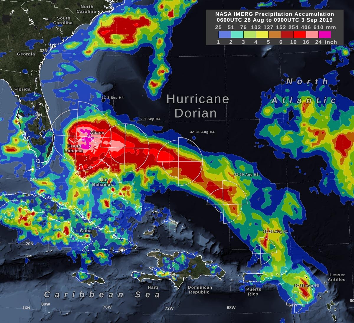
    In the early hours of Tuesday, September 3, Hurricane Dorian had been stationary over the island of Grand Bahama for 18 hours, most of the time as a category 5 hurricane. Storm-total rain accumulation over parts of Grand Bahama and Abaco Islands has exceeded 24 inches (61 cm) according to NASA satellite-based estimates.

    On early Tuesday morning, Dorian’s central pressure had risen and its wind intensity had dropped to category 4 on the Saffir-Simpson scale.  In addition, Dorian had experienced an eyewall replacement cycle on September 2, so by Tuesday morning September 3, the geographic extent of its tropical-storm-force winds had expanded.

    These rain estimates come from the NASA IMERG algorithm, which combines observations from a fleet of satellites, in near-realtime, to provide global estimates of precipitation every 30 minutes. The storm-total rainfall at a particular location varies with the forward speed of the hurricane, the size of the hurricane’s wind field, and with how vigorous the updrafts are inside of the hurricane’s eyewall.

    IMERG, or the Integrated Multi-satellitE Retrievals for GPM (IMERG) data product is generated by NASA’s Precipitation Processing System every half hour with a 6-hour latency from the time of data acquisition. It is produced using data from the satellites in the GPM or Global Precipitation Measurement mission constellation of satellites, and is calibrated with measurements from the GPM Core Observatory as well as rain gauge networks around the world.

    IMERG is an example of the research role that NASA has in hurricanes  – developing observational tools and building computer models to better understand the behavior of tropical cyclones. NASA’s research data is utilized by NOAA’s National Hurricane Center (NHC) to enhance their forecasts.

    On Tuesday, September 3, 2019, at 8 a.m. EDT (1200 UTC), NHC reported at the eye of Hurricane Dorian was located by reconnaissance aircraft and NOAA Doppler radar near latitude 27.1 degrees North and longitude 78.4 degrees West. NHC said Dorian is beginning to move northwestward at about 1 mph (2 kph), and a slightly faster motion toward the northwest or north-northwest is expected later today and tonight.

    At present maximum sustained winds are near 120 mph (195 kph) with higher gusts.  Dorian is a category 3 hurricane on the Saffir-Simpson Hurricane Wind Scale.  Dorian is expected to remain a powerful hurricane during the next couple of days. Hurricane-force winds extend outward up to 45 miles (75 km) from the center, and tropical-storm-force winds extend outward up to 160 miles (260 km). The latest minimum central pressure reported by reconnaissance aircraft is 952 mb (28.11 inHg).

    NHC forecasts a turn toward the north by Wednesday evening, followed by a turn to the north-northeast Thursday morning.  On this track, the core of extremely dangerous Hurricane Dorian will gradually move north of Grand Bahama Island through this evening. The hurricane will then move dangerously close to the Florida east coast late today through Wednesday evening, very near the Georgia and South Carolina coasts Wednesday night and Thursday, and near or over the North Carolina coast late Thursday.

    Never miss a breakthrough: Join the SciTechDaily newsletter.
    Follow us on Google and Google News.

    Hurricane NASA NASA Goddard Space Flight Center
    Share. Facebook Twitter Pinterest LinkedIn Email Reddit

    Related Articles

    NASA Unveils Astonishing Gravity Waves Caused by Hurricane Helene

    Dramatic NASA Satellite Video Examines Hurricane Ida’s Eye in 3D

    NASA’s Aqua Satellite Finds Hurricane Marie Rapidly Intensifying

    NASA Satellite Data Analysis of Rainfall and Rainmaking Capability in Hurricane Sally

    Catastrophic Flooding Possible: NASA Aqua Satellite Eyes Hurricane Sally and Finds Heavy Rain Potential

    Hurricane Nana Caught Making Landfall Under Cover of Night by NASA-NOAA Satellite

    NASA Sees Hanna Strengthen into First Atlantic Hurricane of 2020

    NASA Satellite Spots Major Hurricane Juliette’s Emerging Eye

    NASA’s GISS Releases Data Showing 2011 was Ninth-Warmest Year on Record

    Leave A Reply Cancel Reply

    • Facebook
    • Twitter
    • Pinterest
    • YouTube

    Don't Miss a Discovery

    Subscribe for the Latest in Science & Tech!

    Trending News

    Bone-Strengthening Discovery Could Reverse Osteoporosis

    Scientists Uncover Hidden Trigger Behind Stem Cell Aging

    Scientists Find Way to Reverse Fatty Liver Disease Without Changing Diet

    Could Humans Regrow Limbs? New Study Reveals Promising Genetic Pathway

    Scientists Reveal Eating Fruits and Vegetables May Increase Your Risk of Lung Cancer

    Scientists Reverse Brain Aging With Simple Nasal Spray

    Scientists Uncover Potential Brain Risks of Popular Fish Oil Supplements

    Scientists Discover a Surprising Way To Make Bread Healthier and More Nutritious

    Follow SciTechDaily
    • Facebook
    • Twitter
    • YouTube
    • Pinterest
    • Newsletter
    • RSS
    SciTech News
    • Biology News
    • Chemistry News
    • Earth News
    • Health News
    • Physics News
    • Science News
    • Space News
    • Technology News
    Recent Posts
    • Europe’s Most Active Volcano Just Got Stranger – Here’s Why Scientists Are Rethinking It
    • Why Are Giant Ants Letting Tiny Ants Crawl All Over Them?
    • Revolutionary Technique Sends Healthy Mitochondria Exactly Where They’re Needed
    • This Student Recreated the Universe in a Bottle. What She Discovered Could Help Reveal How Life Started on Earth
    • Alzheimer’s Symptoms May Start Outside the Brain, Study Finds
    Copyright © 1998 - 2026 SciTechDaily. All Rights Reserved.
    • Science News
    • About
    • Contact
    • Editorial Board
    • Privacy Policy
    • Terms of Use

    Type above and press Enter to search. Press Esc to cancel.