NASA satellites are providing a lot of different kinds of data to forecasters at the National Hurricane Center to help them understand what’s happening Hurricane Florence. NASA’s Aqua satellite is providing visible, infrared, and microwave imagery while the GPM core satellite is providing additional data like rain rates throughout the storm and cloud heights.
Last Friday, September 7, Florence was a sheared tropical storm but on Saturday vertical shear lessened and Florence started to get better organized. Today, September 10 Hurricane Florence was rapidly strengthening and became a major hurricane.
NOAA’s National Hurricane Center (NHC) said “Interests in the southeastern and mid-Atlantic states should monitor the progress of Florence. Storm Surge and Hurricane watches could be issued for portions of these areas by Tuesday morning.”
The Global Precipitation Measurement mission or GPM core observatory satellite had a fairly good look at Florence on Sunday, September 9, 2018, at 2:13 p.m. EDT (1813 UTC). GPM is a joint satellite mission between NASA and the Japan Aerospace Exploration Agency called JAXA.
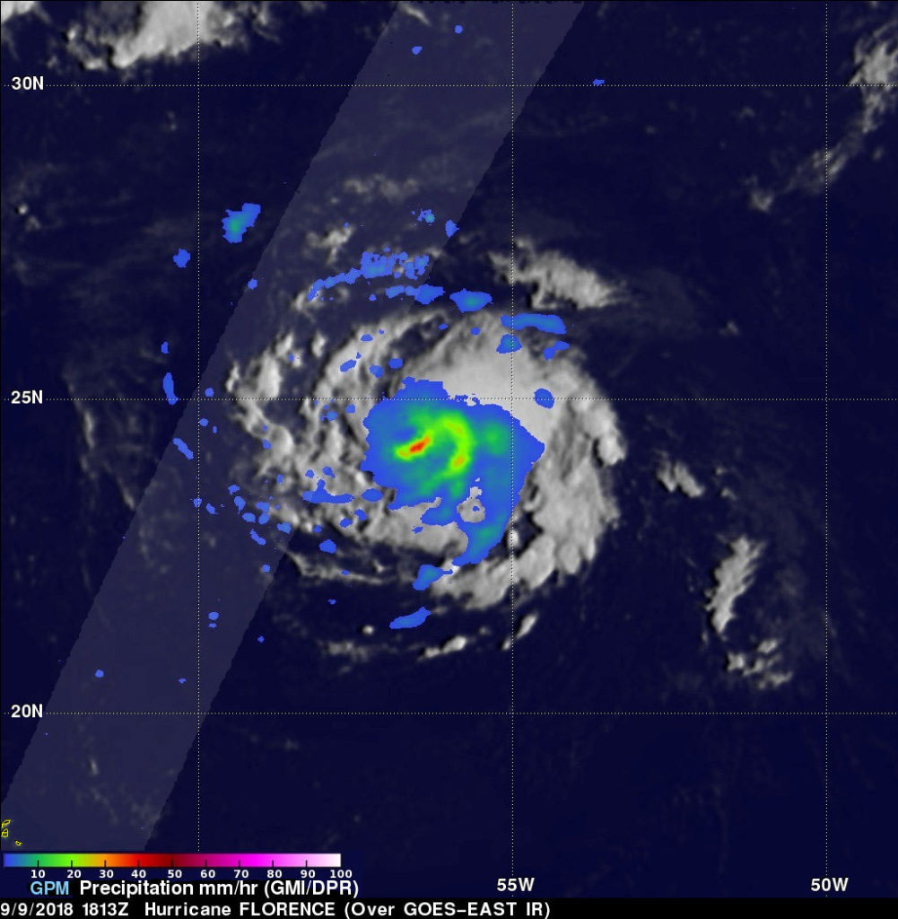
When GPM observed Florence, the intensifying storm had maximum sustained winds of about 70 knots (81 mph) at that time and was still a tropical storm. At the time GPM observed Florence, GPM’s Microwave Imager (GMI) instruments revealed distinct rain bands wrapping around Florence’s southeastern side. Algorithms developed by NASA’s Precipitation Measurement Missions (PMM) team at NASA’s Goddard Space Flight Center in Greenbelt, Maryland were used with GMI data and estimated that precipitation was falling at a rate of greater than 44 mm (1.7 inches) per hour in the rain band.
At NASA Goddard, a 3-D animation was created using data observed by GPM’s radar (DPR Ku Band), that showed the relative heights of storm tops within Florence. Those data were blended with estimates from geostationary satellite cloud top temperatures.
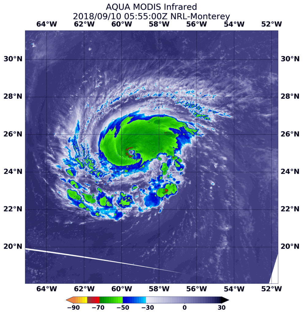
That heavy rainfall was confirmed in NASA infrared imagery the next day, Monday, September 10. At 1:55 a.m. EDT (0555 UTC) on September 10, from the Moderate Resolution Imaging Spectroradiometer or MODIS instrument aboard NASA’s Aqua satellite revealed strongest storms in Florence were in the northern and western parts of the eyewall. In those areas, MODIS found coldest cloud tops had temperatures near minus 70 degrees Fahrenheit (minus 56.6 degrees Celsius). NASA research has found that cloud-top temperatures that cold have the capability to generate heavy rainfall.
At 3:21 a.m. EDT (0721 UTC) the AIRS or Atmospheric Infrared Sounder instrument aboard Aqua provided another, wider infrared view of the storm that showed powerful thunderstorms with cloud tops as cold as or colder than minus 63 degrees Fahrenheit (minus 53 degrees Celsius) made up most of the storm. Temperatures that cold were also found in fragmented bands of storms south of Florence’s center.
Florence’s Status on September 10 at 11 a.m. EDT
At 11 a.m. EDT (1500 UTC), the eye of Hurricane Florence was located near latitude 25.0 degrees north and longitude 60.0 degrees west. Florence is moving toward the west near 13 mph (20 kph). A west-northwestward motion with an increase in forward speed is expected during the next couple of days.
The GPM core observatory satellite had a fairly good look at Florence on Sunday, September 9, 2018 at 2:13 p.m. EDT (1813 UTC). GPM estimated that precipitation was falling at a rate of greater than 44 mm (1.7 inches) per hour in a band of thunderstorms south of Florence’s center. Credit: NASA/JAXA, Hal Pierce
The NHC said, a turn toward the northwest is forecast to occur late Wednesday night. On the forecast track, the center of Florence will move over the southwestern Atlantic Ocean between Bermuda and the Bahamas Tuesday and Wednesday, and approach the coast of South Carolina or North Carolina on Thursday.
Satellite data indicate that maximum sustained winds have increased to near 115 mph (185 kph) with higher gusts. Florence is a category 3 hurricane on the Saffir-Simpson Hurricane Wind Scale. Further strengthening is anticipated, and Florence is expected to be an extremely dangerous major hurricane through Thursday.
Ocean swells generated by Florence are affecting Bermuda and portions of the U.S. East Coast. These swells are likely to cause life-threatening surf and rip current conditions.
The NHC predicts that Florence’s winds will decrease slightly to 125 knots (144 mph) as the hurricane threatens the southeastern United States on Thursday September 13, 2018.
For updated forecasts, visit: www.nhc.noaa.gov
Never miss a breakthrough: Join the SciTechDaily newsletter.
Follow us on Google and Google News.