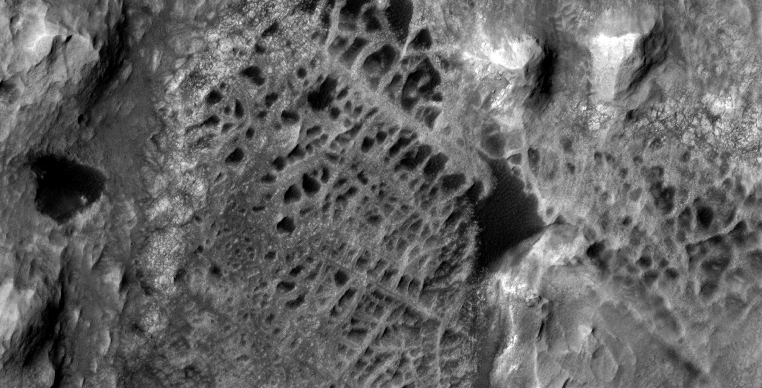
A rugged Martian landscape that resembles a vast spiderweb when seen from orbit is offering new insights into the planet’s watery past.
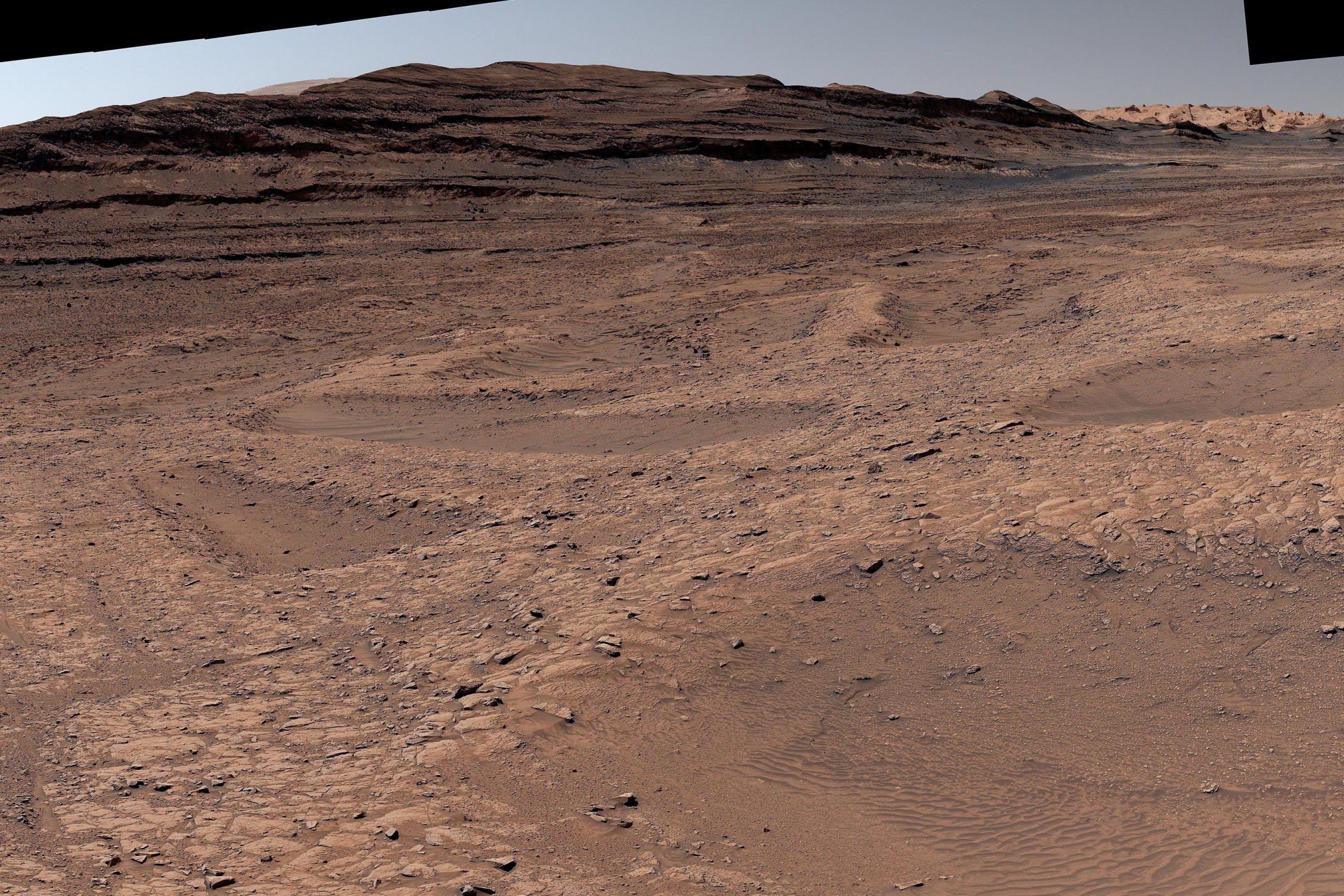
For about six months, NASA’s Curiosity rover has been investigating an area filled with geological features known as boxwork. These formations appear as low, crisscrossing ridges about 3 to 6 feet (1 to 2 meters) tall, separated by sandy hollows. Spanning large distances, the network suggests that groundwater once moved through this region of Mars later than scientists had previously believed. This finding raises fresh questions about how long microbial life might have survived on the Red Planet billions of years ago, before rivers and lakes vanished and Mars became the cold, dry world we know today.
Viewed from space, these formations resemble enormous spiderweb patterns. Scientists think they formed when groundwater traveled through fractures in the bedrock, depositing minerals along the cracks. Over time, those minerals hardened and reinforced the fractured areas, forming ridges. Meanwhile, surrounding rock that lacked this mineral support was gradually worn away by wind, leaving behind the web-like structure.
Before Curiosity reached this region, scientists only had orbital images, and many uncertainties remained about how these formations actually looked up close and how they formed.
What Is Boxwork and Why It Matters
Boxwork features also exist on Earth, but they are usually much smaller, often only a few centimeters tall, and are typically found in caves or dry, sandy environments. The Martian versions are far larger and more widespread. To better understand them, Curiosity’s team set out to study the ridges directly and collect detailed data.
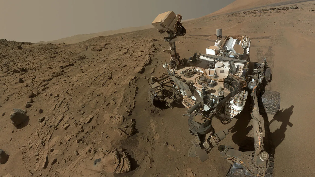
Driving across this terrain is challenging. Engineers must carefully guide Curiosity, an SUV-size rover weighing nearly a ton (899 kilograms), across ridges that can be barely wider than the rover itself.
“It almost feels like a highway we can drive on. But then we have to go down into the hollows, where you need to be mindful of Curiosity’s wheels slipping or having trouble turning in the sand,” said operations systems engineer Ashley Stroupe of NASA’s Jet Propulsion Laboratory in Southern California, which built Curiosity and leads the mission. “There’s always a solution. It just takes trying different paths.”
Climbing Mount Sharp and Tracing Mars’ Climate History
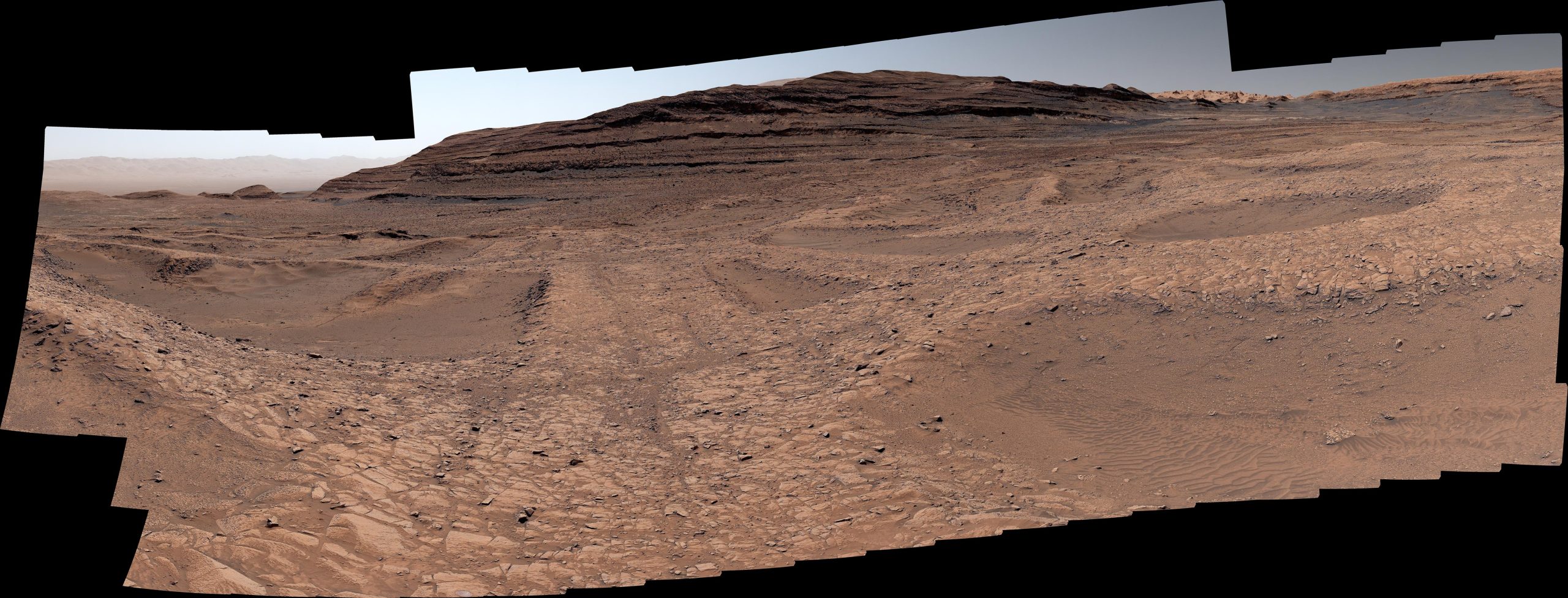
Scientists are also trying to understand how such an extensive network of ridges formed on Mount Sharp, the 3-mile-tall (5-kilometer-tall) mountain that Curiosity is climbing. Each layer of the mountain records a different phase of Mars’ ancient climate. As the rover ascends, the terrain increasingly shows signs that water gradually disappeared over time, although there were occasional wetter periods when rivers and lakes briefly returned.
“Seeing boxwork this far up the mountain suggests the groundwater table had to be pretty high,” said Tina Seeger of Rice University in Houston, one of the mission scientists leading the boxwork investigation. “And that means the water needed for sustaining life could have lasted much longer than we thought looking from orbit.”
Evidence of Groundwater Activity
Earlier satellite images revealed dark streaks crossing the spiderweb-like ridges. In 2014, scientists proposed that these lines might be central fractures where groundwater once moved through cracks in the rock, concentrating minerals.
Curiosity’s close-up observations have confirmed that these dark lines are indeed fractures, supporting that idea.
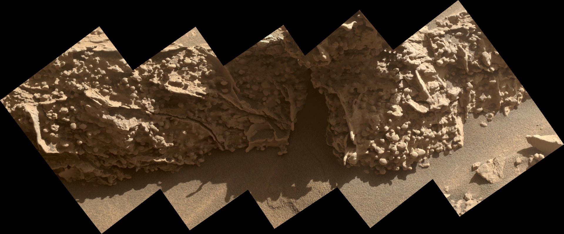
The rover also detected small, rounded bumps known as nodules, which are commonly associated with past groundwater activity and have been observed by multiple Mars missions. Interestingly, these nodules were not found near the central fractures. Instead, they appeared along the sides of the ridges and within the sandy hollows.
“We can’t quite explain yet why the nodules appear where they do,” Seeger said. “Maybe the ridges were cemented by minerals first, and later episodes of groundwater left nodules around them.”
Curiosity as a Mobile Science Lab
Curiosity continues to function as a traveling laboratory, collecting and analyzing rock samples using a drill mounted on its robotic arm. The drill turns rock into powder, which is then delivered to onboard instruments for detailed study.
Last year, the rover analyzed three samples from the boxwork region. One was taken from the top of a ridge, another from bedrock within a hollow, and a third from an area encountered before reaching the ridges. Using X-rays and a high-temperature oven, scientists identified clay minerals in the ridge sample and carbonate minerals in the hollow, offering more clues about how these features formed.
More recently, a fourth sample was examined using a specialized method reserved for particularly important targets. After heating the powdered rock, chemical reagents were introduced to carry out what is known as wet chemistry. This process makes it easier to detect certain organic compounds, carbon-based molecules that are important to life.
What Comes Next for Curiosity
Curiosity is expected to leave the boxwork region sometime in March. This area is part of a layer on Mount Sharp that contains sulfate minerals, which formed as water gradually disappeared from Mars.
Over the next year, the rover will continue exploring this sulfate-rich layer, helping scientists better understand how Mars’ climate evolved billions of years ago.
About NASA’s Curiosity Rover
Curiosity was built by NASA’s Jet Propulsion Laboratory, which is managed by Caltech in Pasadena, California. JPL oversees the mission for NASA’s Science Mission Directorate in Washington as part of the Mars Exploration Program.
Never miss a breakthrough: Join the SciTechDaily newsletter.
Follow us on Google and Google News.
1 Comment
Looks like fossilised leaves