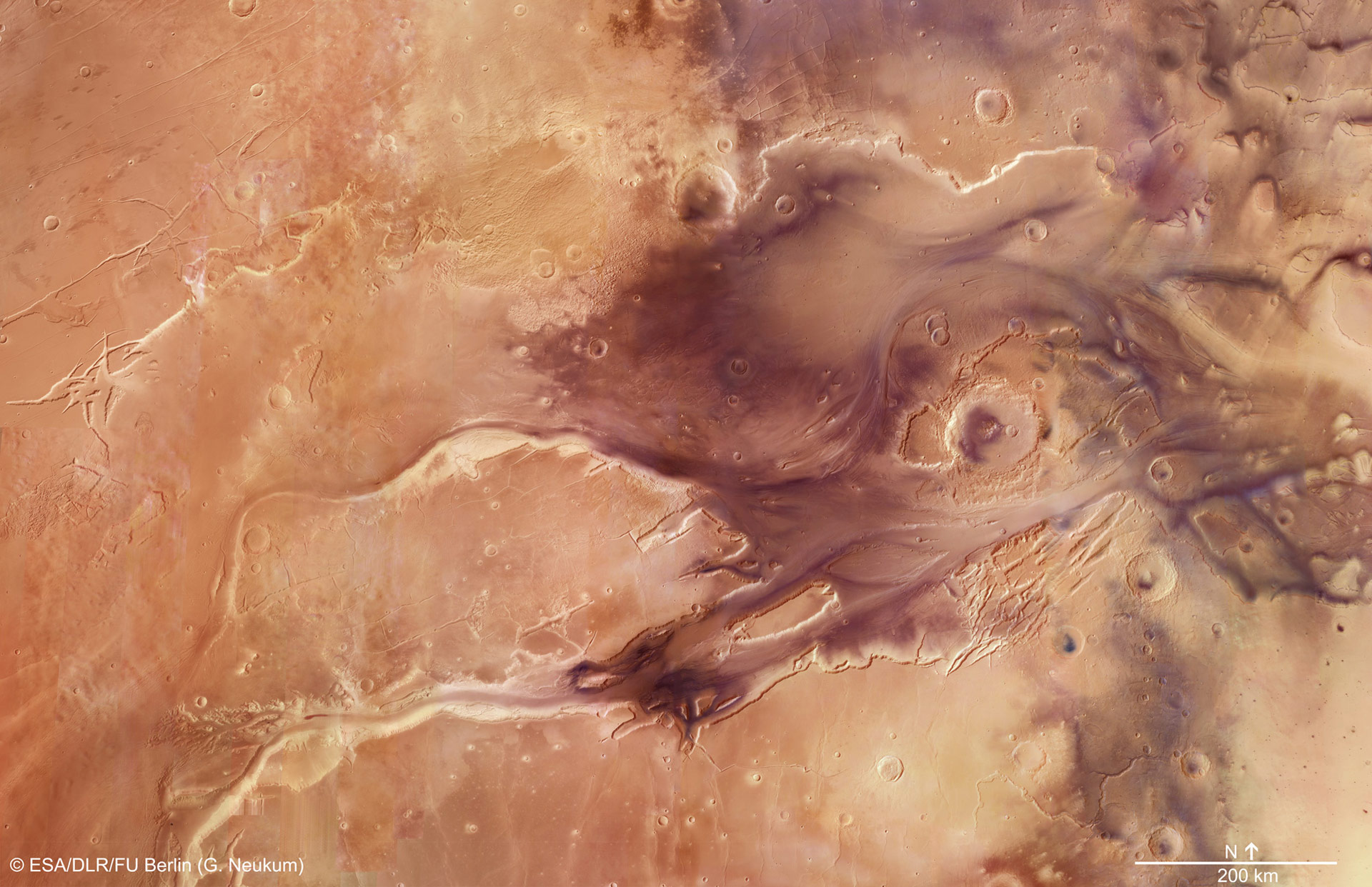
This mosaic, which features the spectacular Kasei Valles, comprises 67 images taken with the High Resolution Stereo Camera on ESA’s Mars Express. The mosaic spans 987 km (613 mi) north–south (19–36°N) and 1550 km (963 mi) east–west (280–310°E). Credit: ESA/DLR/FU Berlin (G. Neukum)
The European Space Agency has released a new five-minute fly-through movie of the ancient flood plain Kasei Valles based on the 67-image mosaic from Mars Express.
Travel across the dramatic flood plains of Mars to celebrate ten years of imaging the Red Planet with Mars Express.
Ten years ago, on January 14, 2004, Mars Express took its very first images of Mars in color and in 3D.
To mark the occasion, the team produced a fly-through movie of the ancient flood plain Kasei Valles. The movie is based on the 67-image mosaic released as part of the ten-year-since-launch celebrations in June 2013. See http://www.esa.int/Our_Activities/Spa…
The scene spans 987 km (613 mi) in the north-south direction, 19-36°N, and 1550 km (963 mi) in the east-west direction (280-310°E). It covers 1.55 million square kilometers (0.6 million square miles) an area equivalent to the size of Mongolia.
Kasei Valles is one of the largest outflow channel systems on Mars, created during dramatic flood events. From source to sink, it extends some 3,000 km (1,900 mi) and descends 3 km (1.9 mi).
Kasei Valles splits into two main branches that hug a broad island of fractured terrain — Sacra Mensa — rising 2 km (0.8 mi) above the channels that swerve around it. While weaker materials succumbed to the erosive power of the fast-flowing water, this hardier outcrop has stood the test of time.
Slightly further downstream, the flood waters did their best to erase the 100 km-wide Sharonov crater, crumpling its walls to the south. Around Sharonov many small streamlined islands form teardrop shapes rising from the riverbed as water swept around these natural obstacles.
The Planetary Science and Remote Sensing Group at Freie Universität Berlin produced the movie. The processing of the High Resolution Stereo Camera image data was carried out at the DLR German Aerospace Center.


Be the first to comment on "New Fly-Through Video of the Ancient Flood Plain Kasei Valles"