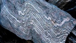
A new method for extracting precise information from tiny “spherules” embedded in layers of rock has allowed researchers to record precise information about asteroids impacting Earth from 3.5 billion to 35 million years ago. West Lafayette, Indiana – Researchers are learning details about asteroid impacts going back to the Earth’s early history by using a [...]
Tag Archives: geology
Earth’s Water Supply Summed Up in One “Tiny” Bubble
May 8, 2012
You’ve probably heard the saying that Earth is mostly water, roughly 70%. Well it turns out that many people have misunderstood the facts and that it’s only the Earth’s surface that is mainly water. To get a better understanding of the limited amount of water on Earth, the USGS gives a visual explanation with one [...]
“Godzillus” Fossil Discovered by Amateur Paleontologist
April 24, 2012
An amateur paleontologist found a mysterious fossilized specimen that may have once lived near the shallow seas that covered what is now the Cincinnati area. Believed to have been similar to a shrub, the fossil measures nearly seven feet long and over three feet wide and may be named “Godzillus.” For 70 years, academic paleontologists [...]
Defects in Mantle Rocks Slow Down the Passage of Seismic Waves
April 23, 2012
A new study from the Australian National University examines defects in rocks found below the earth’s surface in an attempt to better understand how seismic waves travel through the mantle and to gather information that will help geologists better interpret seismological models of the Earth’s internal structure. Defects found in rocks below the Earth’s surface [...]
Himalayan Glaciers Declining Less Rapidly than was Previously Thought
April 20, 2012
A new study suggests that the decline of the Himalayan glaciers due to climate change may be occurring at a slower rate than previously thought. Glaciologists from the University of Zurich studied the glaciers and are reporting average length decreases of 15 to 20 meters with area decreases of 0.1 to 0.6 percent per year [...]
Earth’s Continental Crust Growth Rate has Decreased
March 22, 2012
Newly published research shows that the growth rate of the Earth’s continental crust has decreased significantly over the last three billion years, leaving researchers to believe that an early form of plate tectonics began around three billion years ago. The growth rate of the Earth’s continental crust was high during the first 1.5 billion years [...]
USGS Map Details Volcanos on the Surface of Io
March 21, 2012
This new map was published last Monday by the USGS and it showcases the hellish surface of Jupiter’s moon Io, the most volcanically active object in the Solar System. The creation of the map took over six years, and the map itself identifies 425 volcanoes as well as lava flow fields, squat mountains, deposits left [...]
Groundwater Susceptible to Radium Contamination
February 21, 2012
In a recent study, radium was measured in untreated source water in wells from aquifers that are used for public and domestic water supply. This is the first nationwide study to identify factors that make an aquifer susceptible to radium contamination and researchers found that radium levels are determined by the chemical attributes of the [...]
California Volcano Observatory is USGS’s Newest
February 11, 2012
The USGS announced on Thursday the founding of the new California Volcano Observatory (CalVO), which joins the ranks of the Yellowstone, Cascades, Hawaii, Alaska and Long Valley observatories. CalVO will be tasked with monitoring a region of the US that covers California and Nevada, all out of the USGS offices in Menlo Park. The Cascades [...]
Humans Implicated in Africa’s Deforestation 3,000 Years Ago
February 11, 2012
A new study published in the journal Science suggests that humans might have played a significant part in the sudden deforestation of rainforests from Central Africa. This work contradicts the prevailing view that the expansion of farming practices was the root cause as well as the increased incidence of long, severe dry spells. Germain Bayon, [...]
Lidar Equipment Provides Comprehensive Pictures Earthquake Zones
February 10, 2012
Geologists are using new airborne lidar equipment to study earthquakes and provide comprehensive before-and-after pictures earthquake zones. The lidar (light detection and ranging) equipment can measure features in the surface height to within a few inches by bouncing laser pulses off the ground and measuring their reflection. Geologists have a new tool to study how [...]
Asia and America Will Collide in Millions of Years to Form Supercontinent Amasia
February 8, 2012
In the next 50 to 200 million years, all of Earth’s continents will be once again pushed together into a Amasia, a single landmass around the North Pole. This conclusion comes from a computer model that has been emulating the slow movements of the continents over the next millions of years. The last supercontinent was [...]


May 15, 2012
0 Comments