Declassified images have led to the identification of 396 forts stretching between Syria and Iraq.
Two thousand years ago, the Roman Empire erected forts across the northern Fertile Crescent, a swath of land stretching from present-day western Syria to northwestern Iraq.
New Insights From Cold War Imagery
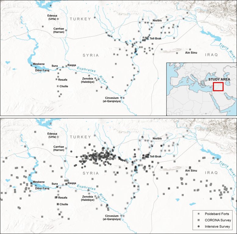
In the 1920s, 116 forts were documented in the region by Father Antoine Poidebard, who conducted one of the world’s first aerial surveys using a WWI-era biplane. Poidebard reported that the forts were constructed from north to south to establish an eastern boundary of the Roman Empire.
A new Dartmouth study analyzing declassified Cold War satellite imagery reveals 396 previously undocumented Roman forts and reports that these forts were constructed from east to west. The analysis refutes Poidebard’s claim that the forts were located along a north-south axis by showing that the forts spanned from Mosul on the Tigris River to Aleppo in western Syria.
The results are published in Antiquity.
“I was surprised to find that there were so many forts and that they were distributed in this way because the conventional wisdom was that these forts formed the border between Rome and its enemies in the east, Persia or Arab armies,” says lead author Jesse Casana, a professor in the Department of Anthropology and director of the Spatial Archaeometry Lab at Dartmouth. “While there’s been a lot of historical debate about this, it had been mostly assumed that this distribution was real, that Poidebard’s map showed that the forts were demarcating the border and served to prevent movement across it in some way.”
Declassified Imagery in Archaeological Research
For the study, the team drew on declassified Cold-War era CORONA and HEXAGON satellite imagery collected between 1960 and 1986. Most of the imagery is part of the open-access CORONA Atlas Project through which Casana and colleagues developed better methods for correcting the data and made it available online.
The researchers examined satellite imagery of approximately 300,000 square kilometers (115,831 square miles) of the northern Fertile Cresent. It is a place where sites show up particularly well and is archaeologically significant, according to Casana. The team mapped 4,500 known sites and then systematically documented every other site-like feature in each of the nearly 5 by 5 kilometer (3.1 mile by 3.1 mile) survey grids, which resulted in the addition of 10,000 undiscovered sites to the database.
Discoveries and Categorization
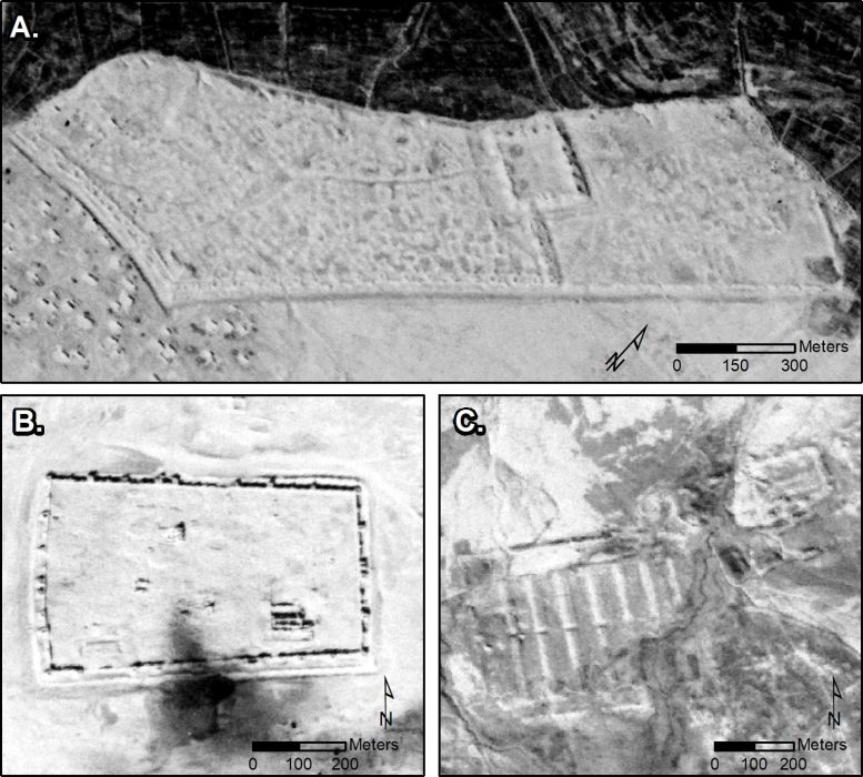
When the database was originally developed, Casana had created morphological categories based on the different features evident in the imagery, which allows researchers to run queries. One of the categories was Poidebard’s forts—distinctive squares measuring approximately 50 by 100 meters (.03 x .06 miles), comparable in size to about half a soccer field.
The forts would have been large enough to accommodate soldiers, horses, and/or camels. Based on the satellite imagery, some of the forts had lookout towers in the corners or sides. They would have been made of stone and mud-brick or entirely of the latter, so eventually, these non-permanent structures would have melted into the ground.
While most of the forts that Poidebard documented were probably destroyed or obscured by agriculture, land use, or other activities between the 1920s and 1960s, the team was able to find 38 of 116 of Poidebard’s forts, in addition to identifying 396 others.
Of those 396 forts, 290 were located in the study region and 106 were found in western Syria, in Jazireh. In addition to identifying forts similar to the walled fortresses Poidebard found, the team identified forts with interior architecture features and ones built around a mounded citadel.
“Our observations are pretty exciting and are just a fraction of what probably existed in the past,” says Casana. “But our analysis further supports that forts were likely used to support the movement of troops, supplies, and trade goods across the region.”
Reference: “A wall or a road? A remote sensing-based investigation of fortifications on Rome’s eastern frontier” by Jesse Casana, David D. Goodman and Carolin Ferwerda, 26 October 2023, Antiquity.
DOI: 10.15184/aqy.2023.153
Never miss a breakthrough: Join the SciTechDaily newsletter.
Follow us on Google and Google News.
1 Comment
“Arab armies,” I doubt Rome was defending herself from arab armies that long ago. The arabs came pouring out of the arabian peninsula in hordes of jihadis to colonize the middle east and beyond. That was after the invention of lsIam.
How great it would be to find roman records covering the many forts and why; including climate information.