A closer look at temperature extremes shows that most U.S. states are warming in distinct ways.
Warming is not showing up the same way everywhere in the United States, and a new analysis suggests that difference matters for how states prepare. The study in the open-access journal PLOS Climate, was led by María Dolores Gadea Rivas of the University of Zaragoza, Spain and Jesús Gonzalo of University Carlos III, Spain.
Climate change is global, but daily weather is lived locally. The researchers argue that many temperature studies miss important details because they focus mainly on the average. Their approach looks across the entire spread of daily temperatures in each state, asking whether warming is showing up in the coldest days, the hottest days, or more evenly across the year.
To separate true long-term shifts from noisy ups and downs, they tested trends with statistical methods designed to hold up even when temperature data have patterns like year-to-year persistence.
To do that, the team built a state-level dataset covering 1950 to 2021. Along with annual averages, they incorporated more than 26,000 daily temperature readings per state, which let them track changes across multiple points in the temperature distribution rather than treating every year as a single number.
Many States Warm in Extremes Even When Averages Don’t
The headline result looks different depending on what you measure. Only 27 states (55%) showed a statistically significant rise in average temperature. But when the researchers examined different slices of the temperature range, 41 states (84%) warmed in at least one part of that distribution. In other words, many places that do not show clear average warming still show meaningful change in the kinds of days people actually experience.
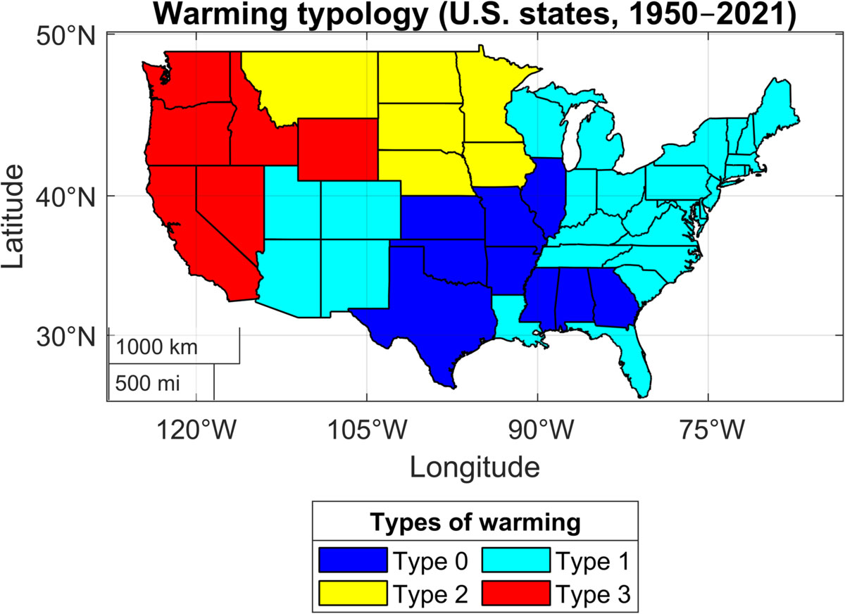
Where that warming lands also varies by region. West Coast states tended to see increases on the hottest end of the year, while many northern states showed stronger warming on the colder end. The paper also highlights a group of states often discussed as part of a Southeastern “Warming Hole,” where the study detected no warming signal across any of the tested temperature levels: Alabama, Arkansas, Illinois, Kansas, Mississippi, Missouri, Oklahoma, and Texas.
Why It Matters for Risk, Planning, and Public Perception
A shift toward hotter extremes can raise heat risk and strain energy demand, while warmer cold extremes can reshape growing seasons and winter-related health risks. The authors also point out that what residents notice, such as scorching highs versus fewer deep freezes, can influence public perception and willingness to support climate action, which feeds directly into state and local decision-making.
The same framework could be used to study other uneven climate impacts in the future, including precipitation changes and sea level rise, especially in a country where climate policy is shaped at both federal and state levels.
The authors summarize: “Looking beyond average temperatures, we show that most U.S. states are warming in specific parts of the temperature distribution, even when average warming is not statistically significant. This reveals strong regional inequalities in how climate change is experienced across the United States.”
Reference: “Regional heterogeneity and warming dominance in the United States” by María Dolores Gadea Rivas and Jesús Gonzalo, 4 February 2026, PLOS Climate.
DOI: 10.1371/journal.pclm.0000808
Never miss a breakthrough: Join the SciTechDaily newsletter.
Follow us on Google and Google News.
2 Comments
“How can we manipulate the data, and how we interpret it, to fit our climate change narrative”
LOL
From the original published article’s Introduction:
“From a physical-climate perspective, spatial differences in warming arise from well-documented mechanisms such as atmospheric circulation patterns, land–ocean thermal contrasts, and feedback processes involving snow and ice cover, precipitation and hydrological-cycle dynamics, and soil moisture e.g.”
That basically makes sense. One doesn’t expect that the range of temperatures in coastal California and Oregon (influenced by the Pacific Ocean), interior Basin and Range states (influenced by the Sierra Nevada), or the Midwest states (influenced by evapotranspiration from agricultural land and forests) to have the same temperature ranges. However, if well-mixed anthropogenic carbon dioxide is the dominant forcing agent because of its claimed retention of out-going IR, I would expect the ‘warming’ to be dominated by increases in nighttime and Winter temperatures, and the slope of the nighttime warming trend to be similar for all states except for micro-climates created by the topography or proximity to large bodies of water.
However, based on what is reported in this study, that doesn’t seem to be the case. That strongly suggests to me that the warming that the globe appears to be experiencing is not exclusively, nor even dominantly, the result of anthropogenic CO2. The correlation between rising CO2 concentrations and temperatures is not a compelling argument for me.