
A 30-meter sediment core extracted from the “Great Blue Hole” in Belize offers the longest continuous record of storm frequency in the Atlantic.
In the shallow waters of the Lighthouse Reef Atoll, located 80 kilometers (50 miles) off the coast of Belize, the seafloor plunges steeply into a striking underwater formation. Known as the “Great Blue Hole,” this 125-meter-deep (410-foot) sinkhole, surrounded by coral reefs, resembles a dark blue eye when viewed from above. It formed thousands of years ago from a karst cave on a limestone island. During the last ice age, the cave’s roof collapsed, and as global sea levels rose with the melting of ice sheets, the cave was flooded.

In the summer of 2022, a team of scientists led by Professor Eberhard Gischler, head of the Biosedimentology Research Group at Goethe University Frankfurt and funded by the German Research Foundation (DFG), transported a drilling platform across the open sea to the “Great Blue Hole.” There, they extracted a 30-meter-long (100 feet) sediment core from the underwater cave. This core contains nearly 20,000 years of accumulated sediment and was later analyzed by researchers from the universities of Frankfurt, Cologne, Göttingen, Hamburg, and Bern.
Coarse layers are a testimony to tropical storms
About 7,200 years ago, the former limestone island that became Lighthouse Reef was submerged by the sea. The sediments at the bottom of the “Great Blue Hole” have since recorded 5,700 years of extreme weather events, including tropical storms and hurricanes.
Dr. Dominik Schmitt, a researcher in the Biosedimentology Research Group and lead author of the study, explains: “Due to the unique environmental conditions – including oxygen-free bottom water and several stratified water layers – fine marine sediments could settle largely undisturbed in the ‘Great Blue Hole.’ Inside the sediment core, they look a bit like tree rings, with the annual layers alternating in color between gray-green and light green depending on organic content.”
Storm waves and surges transported coarse particles from the atoll’s eastern reef edge into the sinkhole, forming distinct layers called tempestites. “The tempestites stand out from the fair-weather gray-green sediments in terms of grain size, composition, and color, which ranges from beige to white,” Schmitt notes.
The research team identified and precisely dated a total of 574 storm events over the past 5,700 years, offering unprecedented insights into climate fluctuations and hurricane cycles in the southwestern Caribbean. Instrumental data and human records available to date have only covered the past 175 years.
Rising incidence of storms in the southwestern Caribbean
The distribution of storm event layers in the sediment core reveals that the frequency of tropical storms and hurricanes in the southwestern Caribbean has steadily increased over the past six millennia. Schmitt explains: “A key factor has been the southward shift of the equatorial low-pressure zone. Known as the Intertropical Convergence Zone, this zone influences the location of major storm formation areas in the Atlantic and determines how tropical storms and hurricanes move and where they make landfall in the Caribbean.”
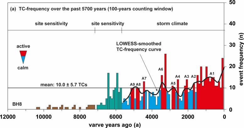
The research team was also able to correlate higher sea-surface temperatures with increased storm activity. Schmitt states: “These shorter-term fluctuations align with five distinct warm and cold climate periods, which also impacted water temperatures in the tropical Atlantic.”
Climate change results in greater storm activity
Over the past six millennia, between four and sixteen tropical storms and hurricanes passed over the “Great Blue Hole” per century. However, the nine storm layers from the past 20 years indicate that extreme weather events will be significantly more frequent in this region in the 21st century.
Gischler warns: “Our results suggest that some 45 tropical storms and hurricanes could pass over this region in our century alone. This would far exceed the natural variability of the past millennia.” Natural climate fluctuations cannot account for this increase, the researchers emphasize, pointing instead to the ongoing warming during the Industrial Age, which results in rising ocean temperatures and stronger global La Niña events, thereby creating optimal conditions for frequent storm formation and their rapid intensification.
Reference: “An annually resolved 5700-year storm archive reveals drivers of Caribbean cyclone frequency” by Dominik Schmitt, Eberhard Gischler, Martin Melles, Volker Wennrich, Hermann Behling, Lyudmila Shumilovskikh, Flavio S. Anselmetti, Hendrik Vogel, Jörn Peckmann and Daniel Birgel, 14 March 2025, Science Advances.
DOI: 10.1126/sciadv.ads5624
Never miss a breakthrough: Join the SciTechDaily newsletter.
Follow us on Google and Google News.
4 Comments
It seems to me that much of the apparent increase in the frequency and intensity of Tropical Cyclones is explained by the ~60m increase in sea level over the past 12,000 years (core contains 20,000-years of sediment) as illustrated here:
https://www.timeandtidebell.org/some-facts/
It allows for complete inundation of the former island and increased lateral transport of debris as the ocean depth increases.
While the actual published article provides uncertainty estimates for the nominal averages and trend lines, no where that I have found is it specified whether that represents +/- one-sigma (68%), or the more common +/- two-sigma (95%). [That included a global search for “sigma” and “uncertainty.”]
There are currently two breaches in the atoll encircling The Great Blue Hole. How certain are the authors that the breaches occurred before their 5,700-year start date? What impact on sedimentation would they expect from surf-zone erosion of those two breaches over the subsequent 5,700 years?
Go down to the Caribbean, live there for 35 years, walk the beaches every day during that time, go through 10 Cat 3 or higher hurricanes, and then you’ll know the answer to your question. Unless you live there and you have done all the analysis that I’ve done, and I have nothing to do with the research of this article or their authors, I can guarantee you, you will come to the same conclusion. The article above I just read myself is something not to ignore. Now if you live in Washington State you obviously don’t have to worry about it. The people who live in the Caribbean including South Florida on the east coast where $2Trillion worth of real estate sits, that’s a major concern. If you live in South Florida, I’m sure you know the cost of insurance. That’s because of what’s happening. In 2024 Florida got hot by 2 Cat 4s and a Cat 1 in June that was a Cat 5 all the way across the Caribbean. So when you ask a question like that, make sure you know what you’re questioning. I can tell you, the probability that Miami or Fort Lauderdale will get hit with a Cat 4 or higher hurricane in 2025 is very high.
Are you saying that your personal experience of 35 years, extrapolated backwards in time, is evidence that the Spanish Galleons should have had smooth sailing on their way back to Spain?
The cost of damage from storms reflects inflation of the dollar and increased population, not just the extent as you suggest.