Discover the fascinating story of Söderfjärden, a meteorite crater in Finland that has witnessed dramatic transformations from being underwater during the Ice Age to becoming fertile farmland that now supports rich biodiversity and agriculture.
This hexagonal crater, renowned among scientists for its unique shape, provides crucial insights into Earth’s geological history and the dynamic processes shaping planetary bodies in our solar system.
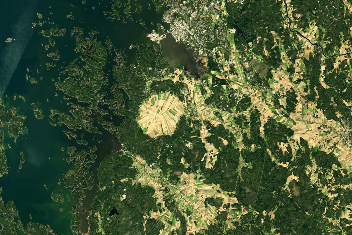
Ancient Cosmic Event
Over 500 million years ago, a meteorite struck Earth near the Antarctic Circle, leaving behind a massive crater several kilometers wide. Over the eons, the slow drift of Earth’s tectonic plates carried this scarred section of the planet’s crust far into the Northern Hemisphere.
Today, this ancient impact site is known as the Söderfjärden crater. It spans 22 square kilometers along the coast of western Finland, near the Gulf of Bothnia, the northern arm of the Baltic Sea. In September 2024, the hexagon-shaped crater was captured in stunning detail by the Operational Land Imager-2 (OLI-2) on Landsat 9. Measuring over 5.5 kilometers (3.4 miles) across from east to west, Söderfjärden is now home to a patchwork of agricultural fields.
Geologic Transformations
In its Scandinavian locale, however, Söderfjärden has not always been on dry land. During the Last Glacial Maximum, around 20,000 years ago, a thick, heavy sheet of ice covered the area and pressed the land down hundreds of meters. Now free of that weight, the land has been bouncing back with some of the highest rates of uplift, or glacial isostatic adjustment, on Earth. New ground emerges from the sea every year.
It’s only in recent centuries that the crater began to appear from beneath the water. It first manifested as a bay (Söderfjärden translates to “south bay”) where people reportedly fished for pike and perch until the 18th century. As the land continued to rise, the crater got progressively drier and eventually transitioned into a wetland area and then an inland depression.
Agricultural Evolution
At first, sedges and reeds thrived in the boggy ground, and people would harvest the vegetation for livestock feed. In the early 19th century, pumps were installed to drain Söderfjärden and increase its cultivatable area. Hay barns then proliferated across the crater, peaking at 3,000 in the 1940s and 1950s, according to the Söderfjärden visitor center.
Today, most of the land is used to grow cereal crops such as barley, wheat, and oats. The fields are also valuable to various bird species and famously attract thousands of common cranes during their spring and autumn migrations. Still low-lying ground, the crater continues to be pumped of water.

Scientific Significance
Söderfjärden interests planetary scientists because of its geometric shape. Some have described the Finnish crater as “the best sample of a hexagonal impact structure on Earth.” Polygonal impact craters, defined as having straight sections along their rims, are a relatively small subset of all impact structures, which tend to be circular. Nonetheless, polygonal impact craters mark the surface of planets, asteroids, and moons throughout our solar system—from Mercury to Pluto’s moon Charon. Instruments on NASA’s Voyager 2, Cassini, MESSENGER, and other spacecraft have imaged many such craters on objects in our solar system.
Scientists believe polygonal impact craters are shaped by underlying geology and that their straight segments form where structures such as faults or other fractures already exist. As a result, the shapes can provide evidence of the geologic past of planets and moons that might otherwise be hidden from view.
NASA Earth Observatory image by Wanmei Liang, using Landsat data from the U.S. Geological Survey.
Never miss a breakthrough: Join the SciTechDaily newsletter.
Follow us on Google and Google News.
1 Comment
Polygonal is about right. Hexagonal is a stretch.