
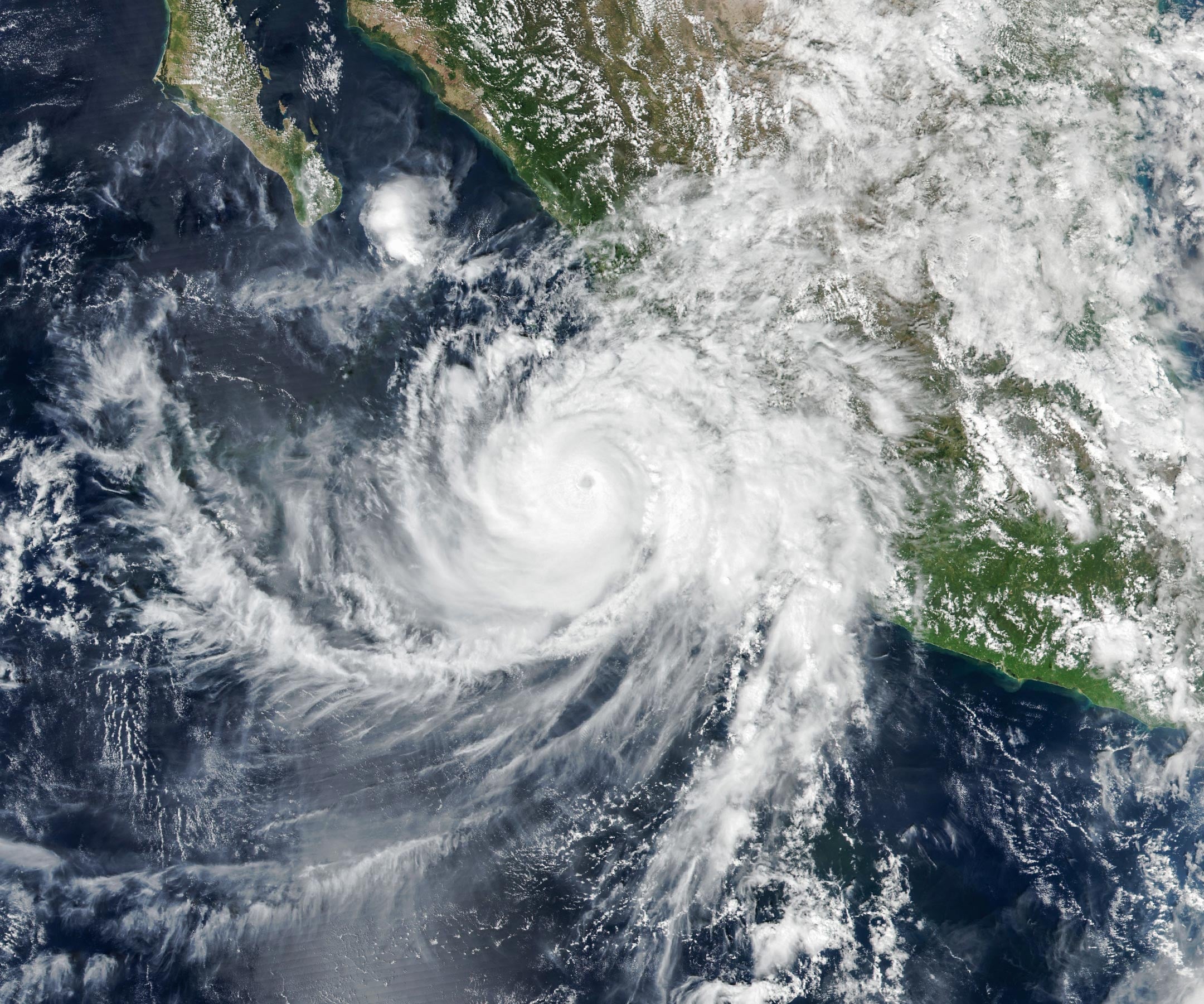
NASA captured strange, rarely seen atmospheric waves rippling high above Hurricane Simon as the powerful storm roared along Mexico’s coast.
Although Hurricane Simon stayed offshore, its powerful winds and heavy rainfall battered parts of Mexico’s Pacific coast, triggering flooding and raising concerns about landslides. Far above the storm, NASA satellites captured an equally remarkable phenomenon: enormous ripples spreading through Earth’s upper atmosphere.
Hurricane Simon became the latest in a long series of tropical cyclones to develop in the Eastern Pacific during the 2026 season. On October 11, the storm approached Mexico as a Category 4 hurricane, with sustained winds reaching 250 kilometers (155 miles) per hour as it slowly moved north-northwest.
Hurricane Simon Brings Powerful Winds and Flooding to Mexico
At approximately 2:30 p.m. local time (20:30 Universal Time) on October 11, the VIIRS (Visible Infrared Imaging Radiometer Suite) instrument aboard NASA’s Suomi NPP satellite captured an image of the hurricane. At that moment, Simon’s eye was positioned roughly 50 kilometers (30 miles) offshore, between the coastal cities of Manzanillo and Puerto Vallarta.
The National Hurricane Center (NHC) reported that sustained winds had decreased to approximately 210 kilometers (130 miles) per hour, although the hurricane’s powerful inner core was still moving close to the coastline. Forecasters suggested that the mountainous terrain of the Sierra Madre was helping weaken the storm and reduce the area affected by its strongest winds.
Despite this weakening, Simon remained a dangerous hurricane. Torrential rainfall caused flooding in coastal communities, including the port city of Manzanillo. The heavy precipitation also increased the threat of mudslides in mountainous regions, according to news reports.
NASA Detects Strange Atmospheric Waves Above the Hurricane
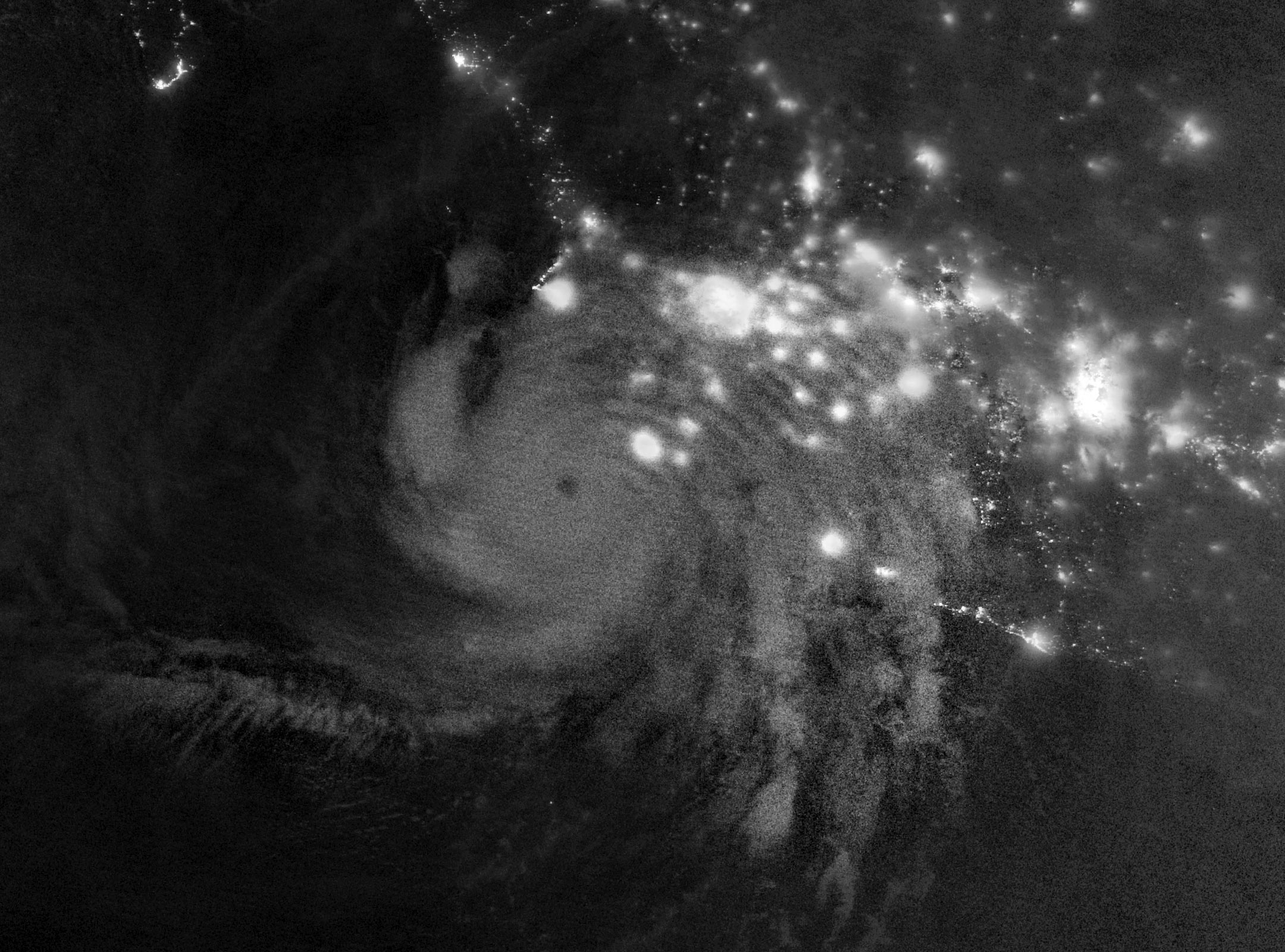
While Simon was producing hazardous conditions near the surface, its influence extended much farther upward. During the early morning of October 11, satellites detected unusual wave patterns spreading through the upper atmosphere.
A nighttime image (above), recorded by the VIIRS instrument aboard the NOAA-21 satellite, revealed atmospheric gravity waves radiating outward from Hurricane Simon. These waves are disturbances in the atmosphere that occur when displaced air moves under the influence of gravity, creating patterns somewhat similar to ripples spreading across water.
In powerful tropical cyclones, the process begins near the eyewall, the ring of intense thunderstorms surrounding the storm’s center. As water vapor condenses, it releases stored energy known as latent heat. This energy helps drive vigorous convection, causing warm, moist air to rise rapidly and form towering cumulonimbus clouds.
The powerful upward motion within these clouds can generate atmospheric waves that travel far beyond the storm itself, reaching the stratosphere and even the mesosphere, two layers of the atmosphere located high above Earth’s surface.
Why These Rare Atmospheric Ripples Were Visible From Space
Although hurricanes can generate atmospheric gravity waves, satellites cannot always detect them. Strong winds at high altitudes may disrupt or weaken the waves before they reach the mesosphere, preventing the distinctive patterns from becoming visible.
When the waves do reach these heights, they can appear as ripples in a phenomenon called airglow. This faint natural light is produced by gases in the upper atmosphere and can reveal subtle disturbances that would otherwise go unnoticed.
The VIIRS instrument includes a specialized day-night band capable of detecting this delicate glow. However, the same sensor also captures moonlight reflected from Earth, which can overwhelm the much fainter airglow signal.
Fortunately, conditions were unusually favorable when the satellite observed Hurricane Simon. The Moon provided very little illumination, allowing the faint atmospheric glow and the striking wave patterns within it to stand out more clearly.
Hurricane Simon’s Unpredictable Path Challenges Forecasters
By the morning of October 13, meteorologists were still struggling to determine how Hurricane Simon would develop. Forecasts of both its future strength and direction carried “very low confidence,” as the storm continued to behave differently than expected.
One possible scenario involved Simon turning north into the Gulf of California before eventually making landfall. Regardless of its precise track, the hurricane was expected to generate large ocean swells and dangerous conditions near shore along portions of Mexico’s southwestern and west-central coastlines over the following days.
NASA Earth Observatory images by Michala Garrison, using VIIRS data from NASA EOSDIS LANCE, GIBS/Worldview, the Suomi National Polar-orbiting Partnership, and the Joint Polar Satellite System (JPSS).
Never miss a breakthrough: Join the SciTechDaily newsletter.
Follow us on Google and Google News.