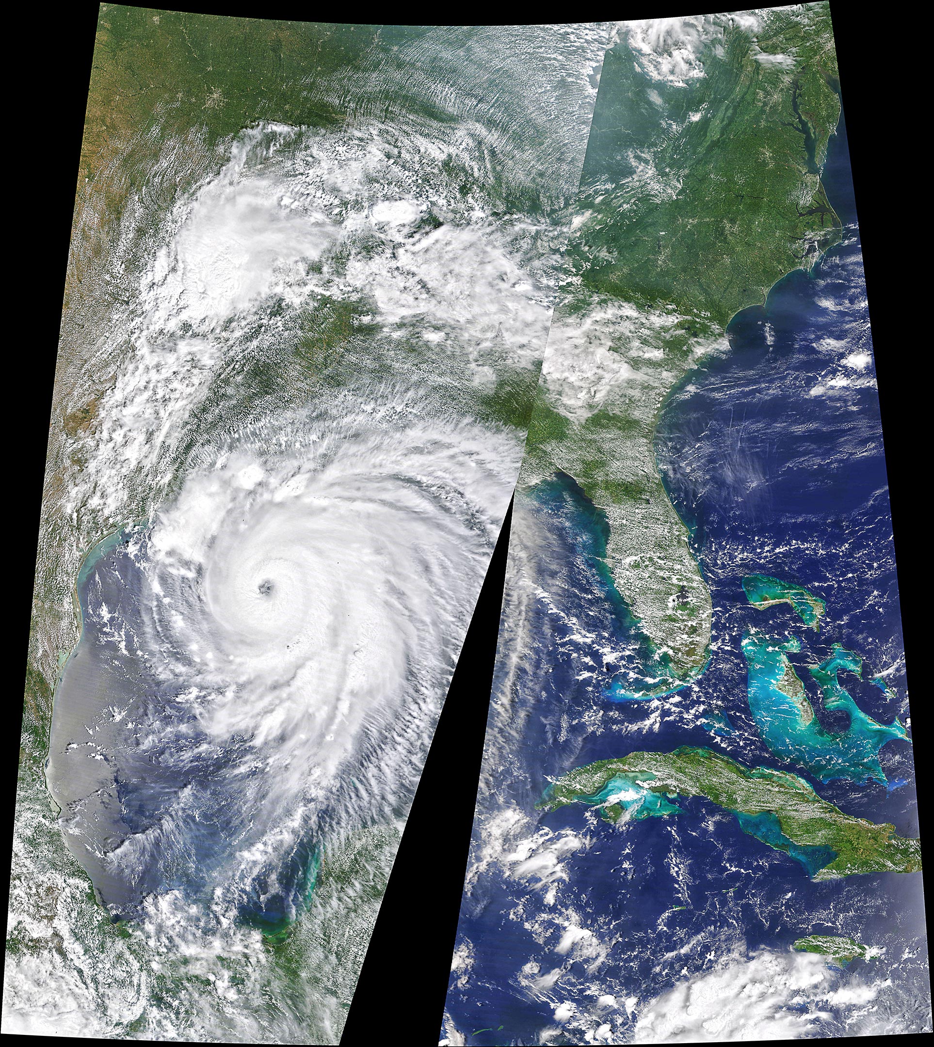
Government meteorologists issued unusually dire warnings as a large hurricane neared the U.S. Gulf Coast on August 26, 2020. After rapidly strengthening as it passed across the Gulf of Mexico, Hurricane Laura was poised to make landfall near the border between Texas and Louisiana. The category 4 storm was expected to unleash strong winds, heavy rains, and a potentially catastrophic storm surge on an area that has not taken a direct hit from a category 4 or 5 storm since the start of modern hurricane records.
The Moderate Resolution Imaging Spectroradiometer (MODIS) on NASA’s Terra satellite acquired a natural-color image (above) of Laura on August 26 at 12:20 p.m. as the storm neared the coast. The storm will make landfall late in the evening on August 26, before marching up the Mississippi Valley.
The gravest concern was for a coastal zone extending from Sea Rim State Park, Texas, to Intracoastal City, Louisiana—an area that National Hurricane Center forecasters warned could face a storm surge of 15 to 20 feet (5 to 6 meters) at the coast and flood waters that penetrate as far as 40 miles (60 kilometers) inland.
A storm surge occurs when cyclonic winds from an approaching storm push a wall of extra water onto the shore. The magnitude of a storm surge depends not only on a hurricane’s winds, but also on its speed, size, and the angle at which it approaches the coast. The timing of astronomical high and low tides can also affect the height of a surge. Storm surges are often the greatest threat to life and property from a hurricane.
Hurricane Laura is also expected to deliver destructive winds and rain. Forecasters anticipate that hurricane-force winds will extend as far as 70 miles (100 kilometers) from the storm’s center into eastern Texas and western Louisiana. They expect rainfall totals of 5 to 10 inches (13 to 25 centimeters), with up to 15 inches in some areas—enough to cause dangerous flash floods.
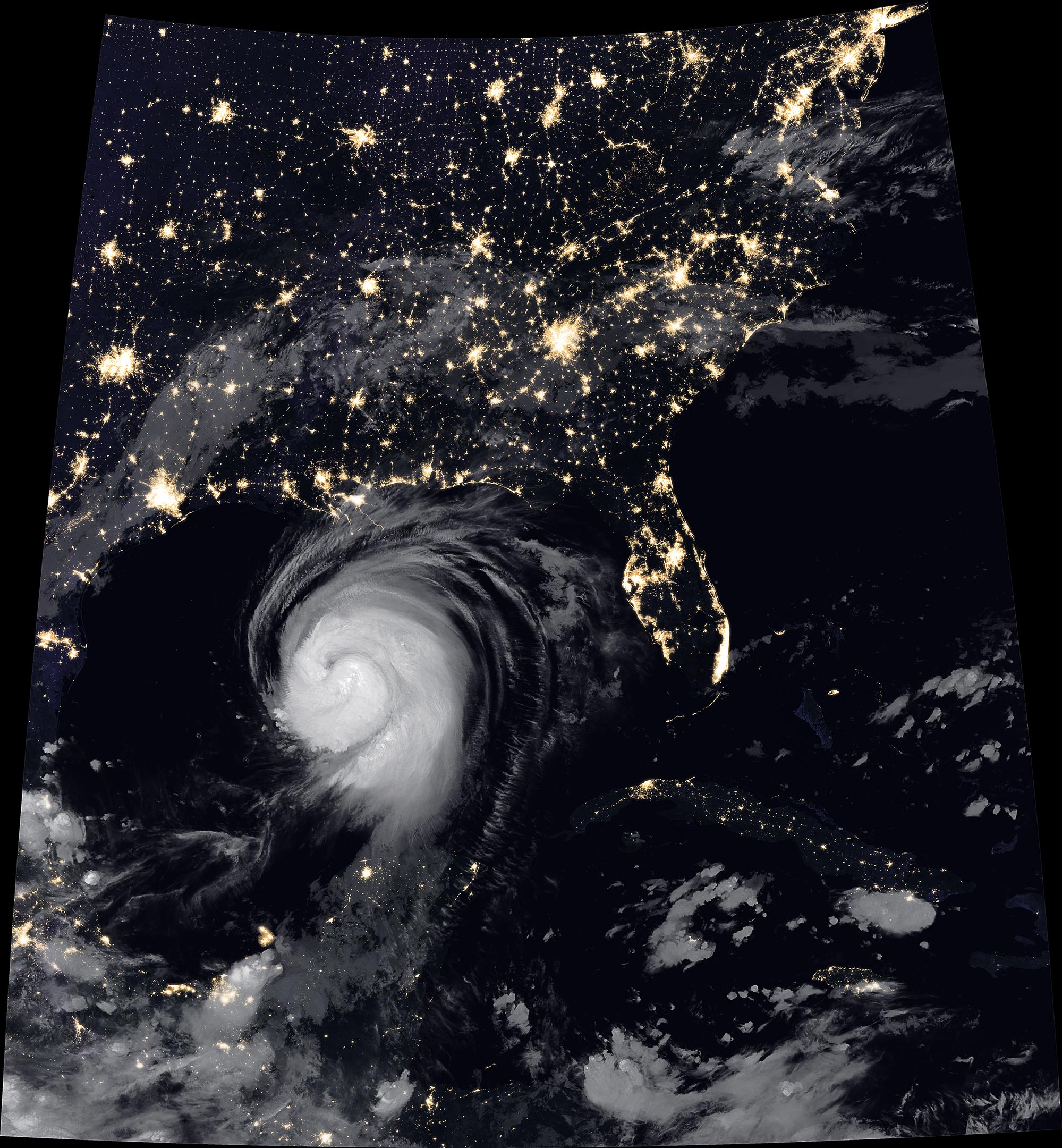
The Visible Infrared Imaging Radiometer Suite (VIIRS) on NOAA-20 acquired this image of Hurricane Laura at 2:20 a.m. Central Daylight Time on August 26, 2020. Clouds are shown in infrared using brightness temperature data, which is useful for distinguishing cooler cloud structures from the warmer surface below. That data is overlaid on composite imagery of city lights from NASA’s Black Marble dataset.
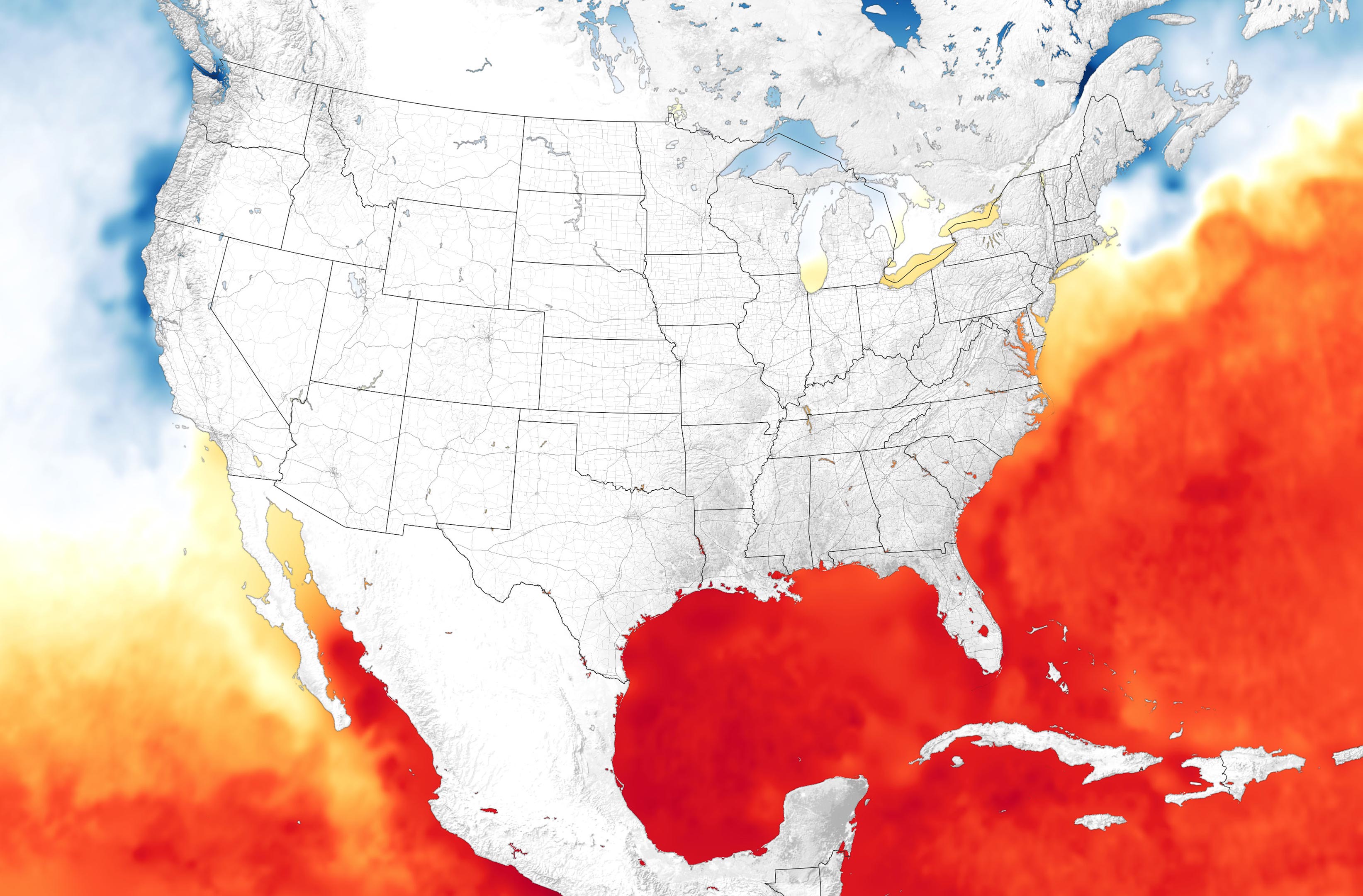
The map below shows sea surface temperatures (SSTs) around the continental U.S. and Mexico as of August 25. Water temperatures in the Gulf of Mexico were running about one degree Celsius (1.8° Fahrenheit) above average. SSTs above 27.8° Celsius (82° Fahrenheit) are generally needed to sustain and intensify hurricanes. Laura underwent a period of rapid intensification as it passed over the warm Gulf waters, with winds intensifying by 50 miles (80 kilometers) per hour over a 24-hour period.
The data for the map come from the MUR Global Foundation Sea Surface Temperature Analysis, produced at NASA’s Jet Propulsion Laboratory. It is based on observations from several satellite instruments, including the NASA Advanced Microwave Scanning Radiometer-EOS (AMSR-E), the Moderate Resolution Imaging Spectroradiometer (MODIS) on the NASA Aqua and Terra platforms, the U.S. Navy microwave WindSat radiometer, the Advanced Very High Resolution Radiometer (AVHRR) on several NOAA satellites.
While warm water can contribute to rapid storm intensification, it is just one of several factors that influence it, explained NASA atmospheric scientist Gary Partyka. “Other things, like efficient outflow in the upper levels of a storm; whether the wind shear is low enough and the atmosphere is stable; and whether dry air is getting into the storm can be quite important as well,” he said. “The science is still quite a way from understanding why some tropical cyclones undergo rapid intensification and others do not.”
One worrisome aspect of this storm is how many oil refining and petrochemical facilities lie in its path. In anticipation of possible problems, NASA’s Applied Sciences Disasters team has been assembling datasets and imagery (based on optical and synthetic aperture radar sensors) from the days leading up to the storm. “We’ll use these to flag anomalous water extent and start assessing damage later in the week, when satellites again pass over after areas that the storm has hit,” explained NASA researcher Lori Schultz.
NASA Earth Observatory images by Joshua Stevens, using MODIS and VIIRS data from NASA EOSDIS/LANCE and GIBS/Worldview, the Joint Polar Satellite System (JPSS), Black Marble data from NASA/GSFC, and data from the Multiscale Ultrahigh Resolution (MUR) project.
Never miss a breakthrough: Join the SciTechDaily newsletter.
Follow us on Google and Google News.