University of Leicester Archaeological Services rediscovers 46 sites at the Eastern Sovereign Base Area at Dhekelia, Cyprus
Scientists from the University of Leicester, collaborating with the Ministry of Defence, have successfully rediscovered over forty archaeological sites in Cyprus, some of which may date back to the Bronze Age, that were previously considered lost to history.
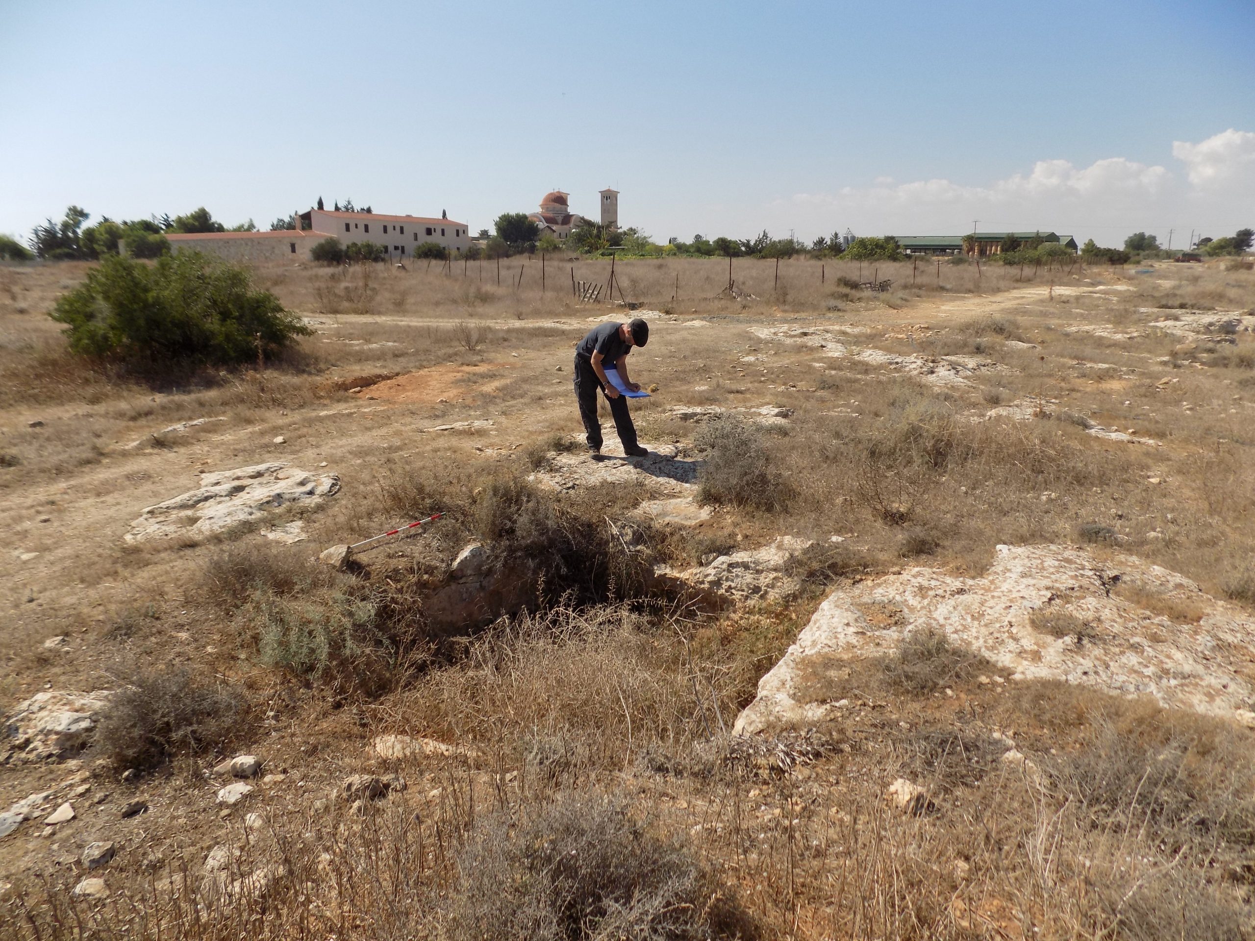
A small team of archaeologists from the University of Leicester Archaeological Services, funded by the DIO Overseas Stewardship Project, undertook a ‘walkover survey’ – a systematic surveying and recording of visible archaeological remains – of the Eastern Sovereign Base Area at Dhekelia (ESBA) on the south coast of the island. The work, licensed by Cyprus’ Department of Antiquities in Nicosia, is to inform site management by the DIO, which is the custodian of the UK and overseas Defence estate.
Dhekelia is about 30km south-east of Nicosia, and 80km north-east of the Western Sovereign Base Area (WSBA) at Akrotiri where the University of Leicester has been working since 2015.
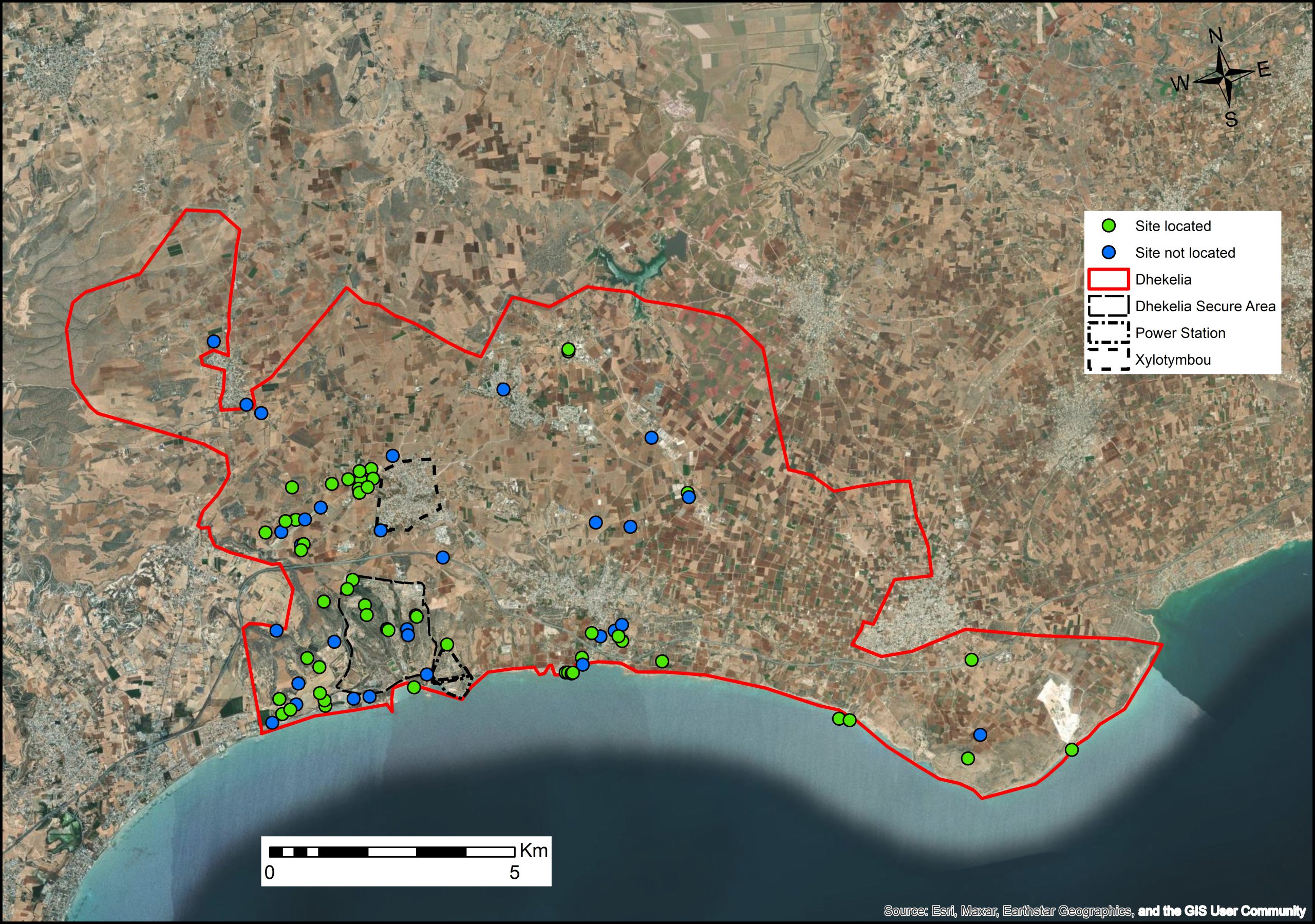
The task of the walkover was to relocate around 60 possible archaeological sites that had been recorded in the early 1960s prior to the development of the garrison within the Dhekelia base, and the laying out of the Kingsfield Airstrip at the western end of the area.
Methodology and Discoveries
In preparation of the survey a Geographic Information System (GIS) record was compiled that included all the known information, and from that coordinate points for the possible sites were exported to standard handheld GPS units. Archaeologists then visited each site and searched for the evidence that had been previously recorded. When successfully found, each site would then be photographed, GPS located, and recorded on pro forma sheets.
In total, 51 sites including 5 historic buildings were located. Some records survived for 47 of the sites, but a further four were known only from labels on a 1:25,000 scale plan. Although the dating of most of the sites is currently unknown, they are likely to span from the Bronze Age which started c.2500 BC to the Byzantine period which ended in the 12th Century AD, and to include sites from the Hellenistic period (312 – 58 BC) and Roman periods (58 BC – 395 AD).
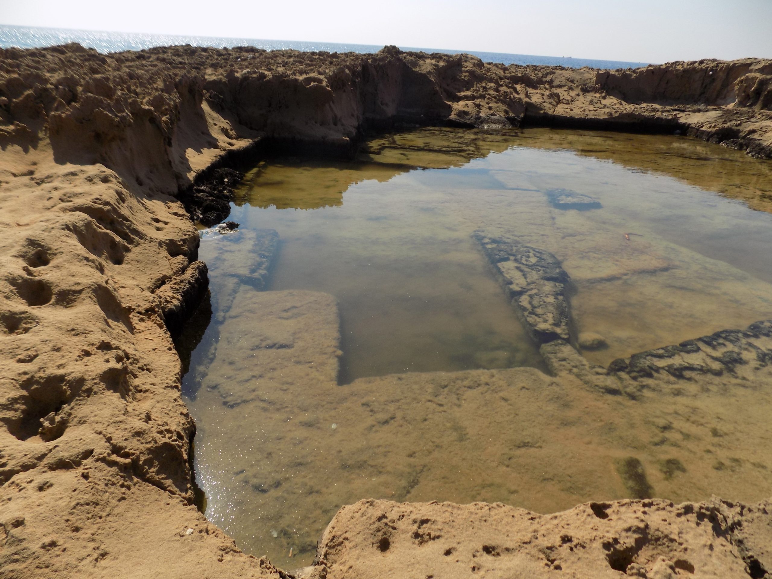
Particular highlights included three coastal quarries where stone was being taken off low spits running out into the sea. One quarry had a little ramp that looked like it was used for loading slabs of quarried rock into boats tied in deep water alongside, and another had dozens of very clear circular grinding stone removals which, where immediately adjacent to each other, left behind distinct clover leaf shapes in the bedrock.
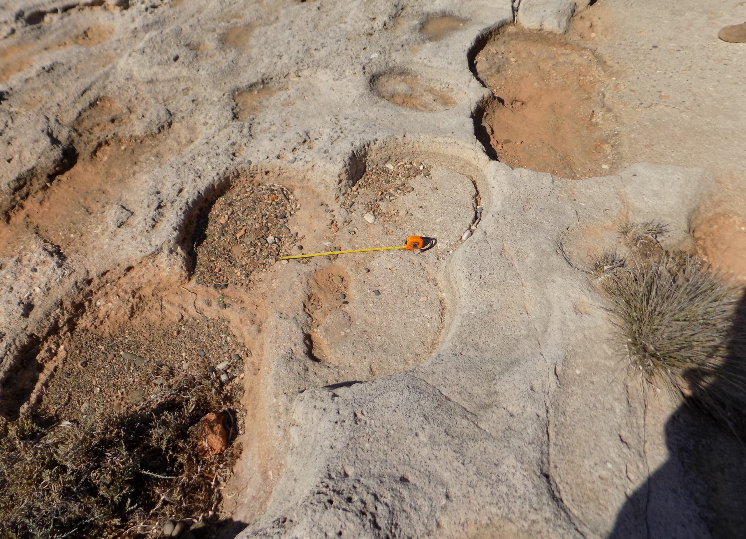
Large areas of rock-cut tomb extended over several hectares in one part of the inland plateau. Most of these tombs were in a very poor state and some bore clear signs of looting in the form of adjacent mounds of earth. Many tombs have been used as convenient areas for fly tipping. One tomb, part of a substantial cemetery surrounding a monastery to the west of Xylotymbou village was being used for caging cats.
Challenges and Successes
Matt Beamish from the University of Leicester Archaeological Services, who led the survey, said: “Our GIS and survey methods had worked well when used for a similar survey of the Akrotiri peninsula in 2019. Many of the sites we were planning to survey had been last visited over 20 years ago, and in many instances had been reported as no longer existing or being unfindable. On reflection this had more to do with inadequate mapping, lack of preparation, and lack of satellite location technologies: we found that many of the sites could be re-found with a little bit of patience.
“There were undoubtedly problems with some of the archive information which was incomplete and had been inaccurately redrawn at some stage in the past. Some sites had clearly been lost to the subsequent development of roads and buildings.”
The Dhekelia Sovereign base is around 20km wide and 7km deep and sits on the east side of Larnaca Bay. The topography is varied including a flat coastal strip meeting steep limestone cliffs and hills, with a broadly flat plateau on the interior which includes more areas of rocky outcrop and is bisected by rivers which are generally dry beds under cultivation. The coastal strip and plateau include areas of agriculture and horticulture, and areas of olive and citrus grove and scrub. In the north of the area, there are large dairy and livestock farms.
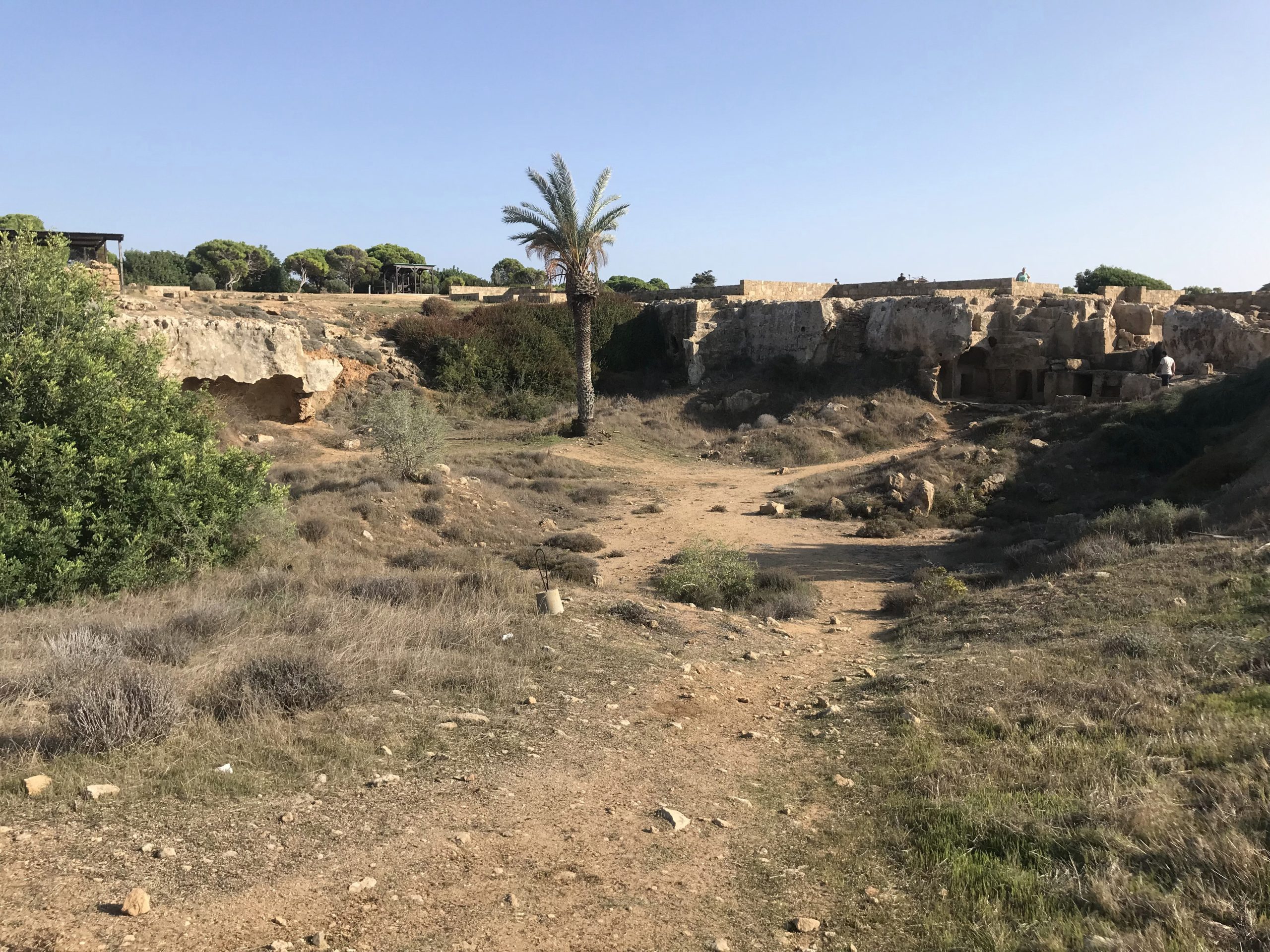
Cyprus’ position on Mediterranean sea routes has led to a rich and diverse cultural heritage, and it is famed for the preservation of many archaeological sites from the Bronze Age, Hellenistic/Iron Age, Roman, and Byzantine or medieval periods. At the western end of the Dhekelia area, this occupation is represented in a significant archaeological landscape comprising a large Bronze Age-defended hilltop settlement at Kokkinokremnos and an adjacent Iron Age hillfort at Vikla, both sitting above the Roman harbor town of Koutsopetria: all these protected sites are subject to recent research excavations. The Roman harbor is all now infilled, possibly stemming from a catastrophic tsunami event.
Implications for Heritage Management
Much of the known archaeology across Dhekelia is funerary, and this mostly comprises rock-cut tombs, some of which were built into the limestone caves (generally Hellenistic/Iron Age), and rock-cut shaft graves (generally Byzantine/Roman-Medieval).
Matt Beamish added: “The survey was very successful with the identification of significant archaeological areas. We know that many more archaeological sites will exist which are not obvious to the naked eye. Much of the area has seen no systematic archaeological survey, and the application of remote sensing or aerial survey perhaps using LiDAR would enable a wider picture of previous human activity to be drawn. The information will enable the DIO to better manage the archaeological sites within the Sovereign Base Administration Area, and allow a wider understanding of Dhekelia’s archaeological heritage.”
Alex Sotheran, Archaeology Advisor, DIO, praised the survey and the results: “The work carried out by Matt and the team has really improved our knowledge and understanding of the archaeology across the Dhekelia area and will allow for an improved system of management of these vital and important heritage assets going forward.”
David Reynolds, Environmental Advisor (Cyprus), DIO, added: “Along with the University of Leicester team, we would like to thank the Republic of Cyprus Department of Antiquities and the Sovereign Base Area Office (Dhekelia) for all their support and guidance in making this extremely valuable piece of work happen.”
The data created during the survey has been entered into DIO’s Historic Buildings, Sites and Monuments Record, which in turn is vital for helping to protect the historic environment across the Ministry of Defence’s UK and overseas estate.
Additionally, the archaeological data has been shared with the Republic of Cyprus Department of Antiquities (DoA) as part of a Protocol for Collaboration between British Forces Cyprus and the Republic of Cyprus DoA. The protocol will ensure that potential impacts on archaeology will be actively considered alongside military training activities and infrastructure work across the Sovereign Base Areas of Akrotiri and Dhekelia. It also sets out procedures for managing any archaeological remains uncovered during construction projects.
Never miss a breakthrough: Join the SciTechDaily newsletter.
Follow us on Google and Google News.