This is the second installment of a two-part series about the Shuttle Radar Topography Mission. Read part one here.
Elevation data collected during a space shuttle mission in 2000 continues to inform science and society in unexpected ways.
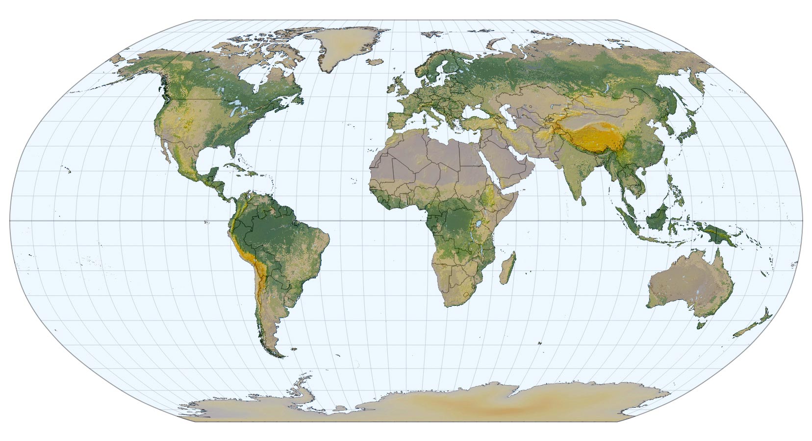
In a pivotal 2000 mission, the space shuttle Endeavour’s SRTM project provided a 3D view of Earth’s terrain, capturing data crucial for diverse scientific applications. This mission laid the groundwork for the NASADEM model, enhancing global topography understanding and benefiting areas like disaster response and urban planning. Recent advances continue to build on this rich data legacy, underscoring its enduring value.
Pioneering Space Shuttle Mission
In 2000, the space shuttle Endeavour flew its final scientific mission upside down and backward. With the bay doors open toward Earth below, the instruments of the Shuttle Radar Topography Mission (SRTM) scanned the planet with cloud-penetrating radio signals. With one detector at the end of a telescoping 200-foot mast and another in the shuttle’s bay, SRTM offered an unprecedented 3D view of Earth.
It wasn’t the last time Endeavour went to space; there would be 11 more flights over the following decade, primarily dedicated to supporting the International Space Station. A quarter century later, though, the SRTM flight stands out as one of Endeavour’s most significant scientific missions in its 19 years of service.
A Data Treasure Trove Unlocked
The SRTM system recorded data on magnetic tapes that resembled large video tapes. Because the scanning ran 24 hours a day for the duration of the mission, the Endeavour crew split into two teams, working alternate shifts to change tapes every half hour. In all, they gathered 12 terabytes of data on 320 tapes over nearly 10 days. After a few years of data processing, in 2003, the U.S. Geological Survey (USGS) made the resulting topographical maps publicly available for free.
Initially, the USGS distributed high-resolution maps of the U.S., with each pixel representing an area 100 feet (30 meters) on a side, roughly twice the size of a basketball court. Maps of the rest of the planet initially featured lower-resolution pixels 300 feet (90 meters) across. In 2015, the USGS released full-resolution maps for the entire globe. Finally, in 2020, NASA produced a new topographical map, designated NASADEM (NASA Digital Elevation Model), created with SRTM data that had been reprocessed to improve the height accuracy of features. It also included data from other mapping missions to fill in holes in the earlier maps.

SRTM Benefits Science, Society, Economics, and the Environment
Elevation is crucial information for a spectrum of scientific studies, including many that directly address the safety and livelihoods of people around the planet. In areas susceptible to flooding and landslides, estimates suggest that thousands of lives could be saved each year by combining rainfall information with elevation maps to predict landslide dangers (pictured above). Among the data’s social justice applications, SRTM-based maps are proving crucial to the placement of health services and clinics for people in areas of difficult terrain in Sub-Saharan Africa.
Landscape features in regions of the world that are difficult to access would likely remain hidden today if it weren’t for SRTM and NASADEM. Recently, Landsat 8 images overlayed on SRTM elevation maps have revealed the extraordinary depths of the remote Cotahuasi Canyon in Peru and exposed enormous folded rock landscapes in Canada, scoured clean by retreating glaciers after the last ice age. Both areas are pictured below, respectively.


In the decades since the shuttle mapping mission, SRTM data have helped researchers identify active fault lines that could be the source of earthquakes in Afghanistan, estimate mangrove loss in Malaysia due to deforestation, and even determine how the locations of power-generating wind turbines affect real estate values. Tens of thousands of research papers are published every year that rely on SRTM maps for these and other environmental, economic, agricultural, and public safety studies.
Expanding the Frontiers of Topography
Other space-based measurements have added to our knowledge of Earth’s topography since SRTM. Satellite missions such as NASA’s ICESat (Ice, Cloud, and land Elevation Satellite), its successor ICESat-2, and an instrument aboard the International Space Station called GEDI (Global Ecosystem Dynamics Investigation) have collected trillions of precise laser measurements that have improved the accuracy of the maps. The European Space Agency’s Copernicus program used additional satellite and modeling data to create even more datasets of Earth’s surface heights. Improvements to space-based topographic maps will continue with the launch of the NASA-ISRO Synthetic Aperture Radar, which will provide new, more precise measurements of Earth’s surface.
Sustained Impact and Future Prospects
Although future mapping efforts may offer improved views of Earth, the value of the SRTM data shows no signs of diminishing, said Gerald Bawden, who oversees the SRTM program at NASA Headquarters. “The magic of SRTM is that we clearly had a near-global snapshot,” he said. “It took less than two weeks to collect, but it now provides a baseline for everything from climate change and geologic hazards to urban planning and deforestation. This is a gold mine of information for coming generations.” Bawden expects SRTM-derived maps to be an invaluable resource until the end of the century and beyond.
For Scott Hensley, the senior research scientist at NASA’s Jet Propulsion Laboratory (JPL) who helped develop the instrument, the SRTM effort is both professionally and personally significant. “I’ve worked on a lot of cool missions, but SRTM is one of the highlights of my career at JPL,” Hensley said. “It’s one of the things that I’m really proud of because of its scientific and public benefits. I know that I’ve contributed to the betterment of humankind by working on this mission.”
NASA Earth Observatory image by Michala Garrison, using topographic data from the Shuttle Radar Topography Mission (SRTM). Landslide susceptibility map by Jesse Allen, using data provided by Thomas Stanley and Dalia Kirschbaum (NASA/GSFC), and topographic data from SRTM. Canyon and rock fold images by Joshua Stevens, using topographic data from SRTM and Landsat data from the U.S. Geological Survey. Story by James Riordon/NASA’s Earth Science News Team.
Never miss a breakthrough: Join the SciTechDaily newsletter.
Follow us on Google and Google News.