(Click image for full view.)
A large algal bloom near Japan shows how ocean currents and nutrients support phytoplankton, which are vital for marine life and climate regulation.
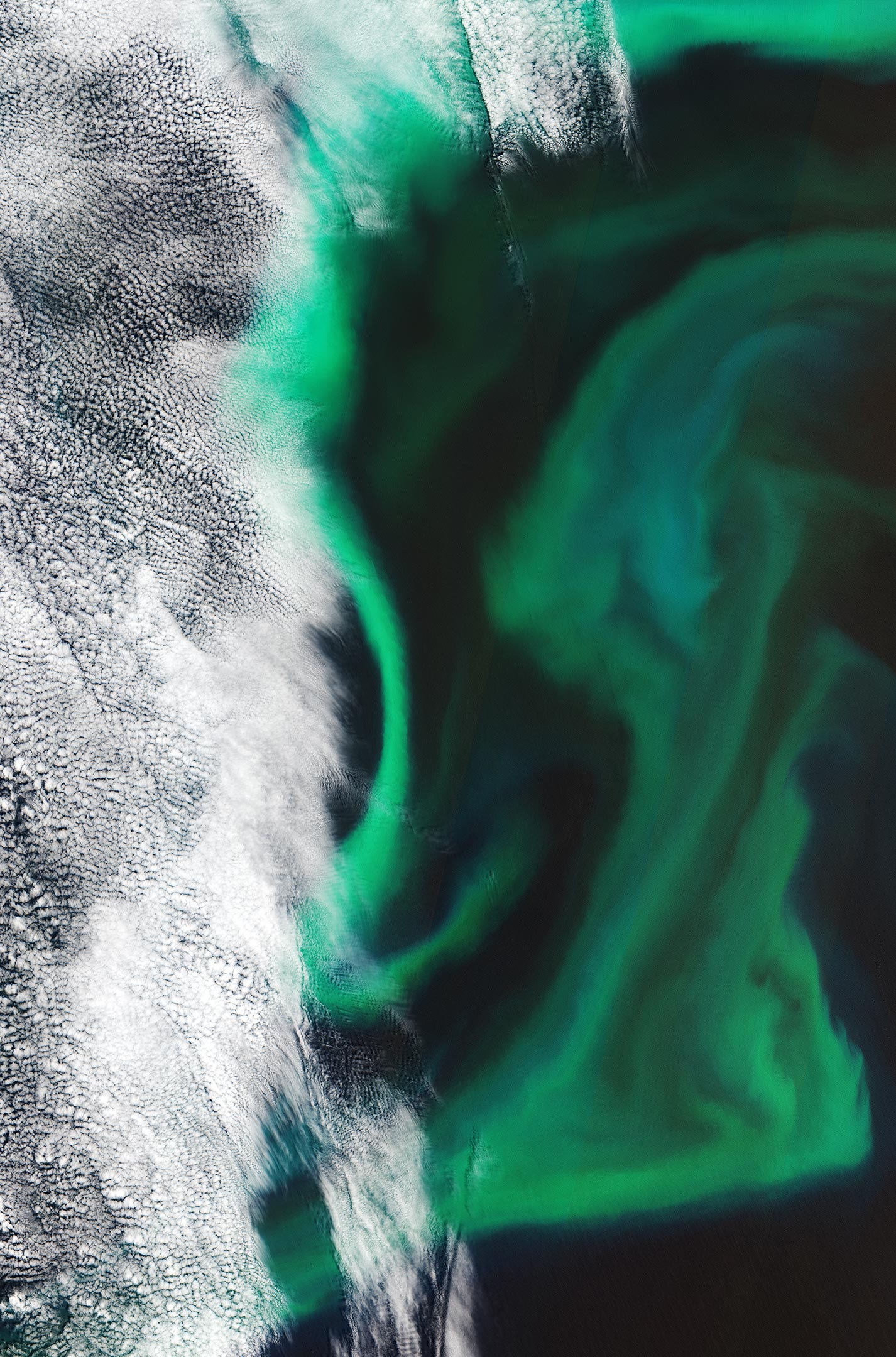
The Copernicus Sentinel-2 mission takes us over the algal blooms swirling around the Pacific Ocean, just off the coast of Japan.
Algae blooms refer to the rapid multiplying of phytoplankton – microscopic marine plants that drift on or near the surface of the sea. Excessive algal growth, or algal blooms, can become visible to the naked eye and collectively tint ocean waters, allowing us to detect these tiny organisms from space.
Although algal blooms are a natural and essential part of life in the sea, human activity is also said to increase the number of annual blooms. Harmful algal blooms can be stimulated by environmental factors, such as light, warmer water temperatures, and excessive nutrients.
In the image pictured here, captured on June 14, 2019, high concentrations of algae can be seen around 130 km (80 mi) off Hokkaido Island, the second largest island of Japan. This particular algal bloom measured more than 500 km (310 mi) across and 200 km (124 mi) wide, with the area pictured here showing just a small portion of the bloom, around 100 km from north to south and around 110 km from east to west.
During the spring bloom season, nutrients such as nitrates and phosphates are more abundant in the surface waters. Without direct in situ measurements, it is difficult to distinguish the type of algae that cover the ocean here. Algae is then usually carried by winds and currents closer to the coast of Japan.
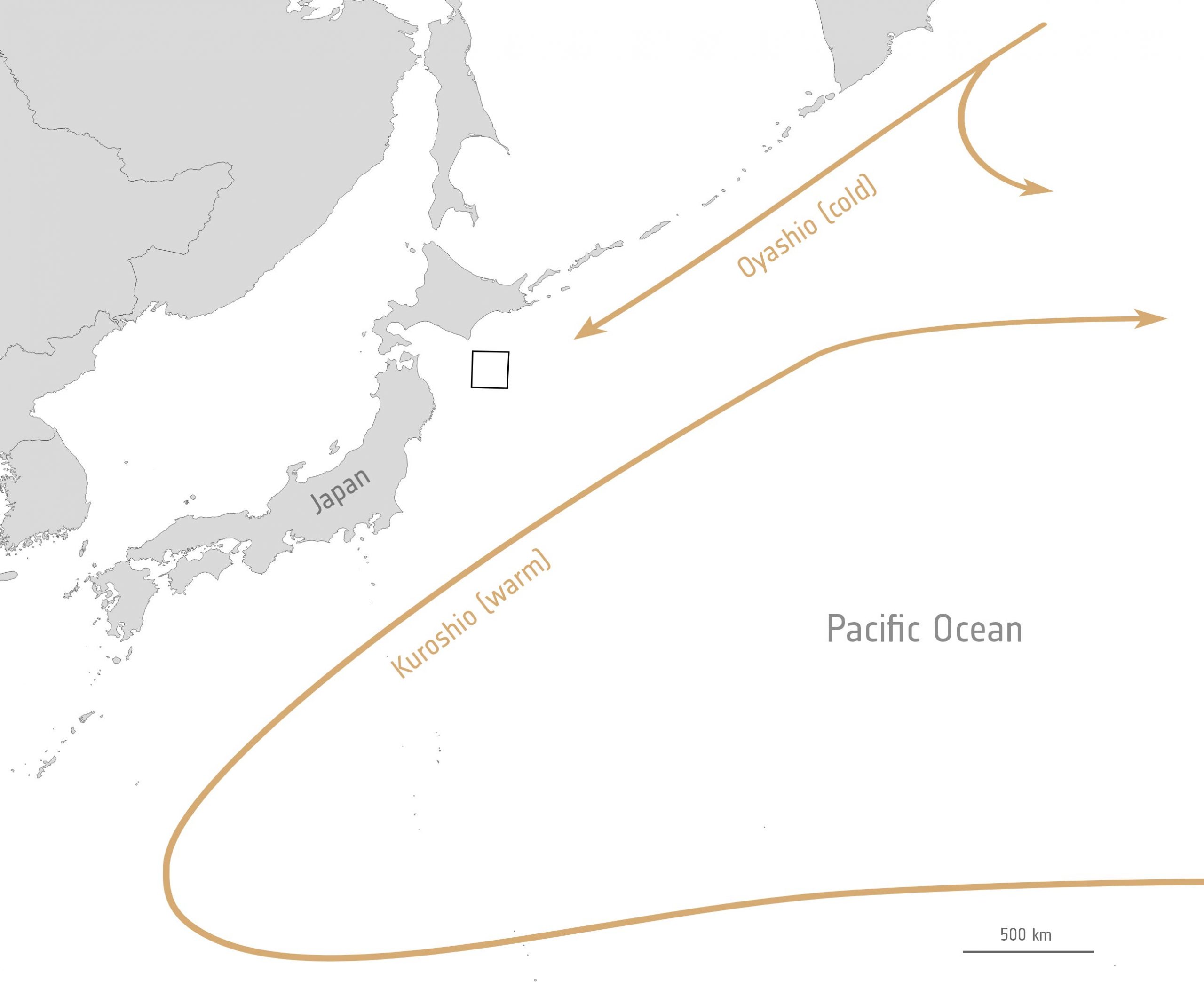
It is in this part of the Pacific Ocean, near Hokkaido, where the colder Oyashio Current converges from the north with the warmer Kuroshio Current, which flows from the south. When two currents with different temperatures and densities collide, they often create eddies – swirls of water drifting along the edge of the two water masses. The phytoplankton growing atop the surface waters become concentrated along the boundaries of these eddies and trace out the motions of the water.
Phytoplankton play an important role in the food chain, but they also have an impact on the global carbon cycle by absorbing carbon dioxide on a scale equivalent to that of terrestrial plants. Primary production is often used to describe the synthesis of organic material from carbon dioxide and water through photosynthesis. Even small variations in primary productivity can affect carbon dioxide concentrations, as well as influencing biodiversity and fisheries.
As ocean surfaces warm in response to increasing atmospheric greenhouse gases, phytoplankton productivity will need to be monitored both consistently and systematically.
Satellite data can not only be used to track the growth and spread of harmful algae blooms in order to alert and mitigate against damaging impacts for tourism and fishing industries, but have also recently proven fundamental to providing a global view of phytoplankton and their role in, and response to, climate change.
Never miss a breakthrough: Join the SciTechDaily newsletter.
Follow us on Google and Google News.
2 Comments
“As ocean surfaces warm in response to increasing atmospheric greenhouse gases, …”
The obligatory reinforcement of the evil of CO2 in the mind of naive readers.
Warm air CAN transfer energy to the surface of the water, but that can also result in evaporation, which cools the water. Air has low thermal conductivity and a low specific heat. Thus, it is actually less effective in heating water than water is in heating cold air. The majority of the warming of waters in the mixing zone is the result of sunlight being absorbed, not from conductivity of heat energy at the boundary between air and water.
harvest that stuff, make it into fish food for aquaculture. Imagine the harvesters getting this kind of real-time GPS in order to make their most energy and productivity efficient runs. In the phosphorus-rich dead zones caused by runoff, analyze the water in order to encourage nontoxic highly nutritious blooms to be harvested as a first step in addressing these problem areas, while recovering valuable nitrogen and phosphorous resources and simultaneously harvesting a valuable economic precursor to large scale aquaculture.