The Copernicus Sentinel-2 mission takes us over Qeshm Island – the largest island in Iran.
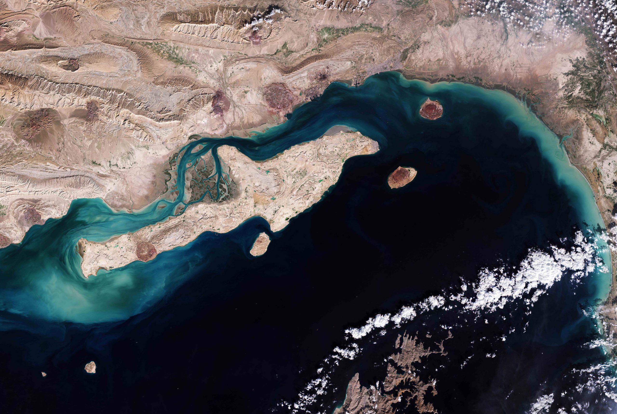
Qeshm Island lies in the Strait of Hormuz, parallel to the Iranian coast from which it is separated by the Clarence Strait (Khuran). With an area of around 1200 sq km (460 sq mi), the island has an irregular outline and shape often compared to that of an arrow. The island is approximately 135 km (84 mi) long and spans around 40 km (25 mi) at its widest point.
The image shows the largely arid land surfaces on both Qeshm Island and mainland Iran. The island generally has a rocky coastline except for the sandy bays and mud flats that fringe the northwest part of the island.
The Hara Forest Protected Area, a network of shallow waterways and forest, can be seen clearly in the image, between Qeshm Island and the mainland. Hara, which means ‘grey mangrove’ in the local language, is a large mangrove forest and protected area that brings more than 150 species of migrating birds during spring, including the great egret and the western reef heron. The forest also hosts sea turtles and aquatic snakes.
The dome-shaped Namakdan mountain is visible in the southwest part of the island and features the Namakdan Cave – one of the longest salt caves in the world. With a length of six kilometers (3.7 miles), the cave is filled with salt sculptures, salt rivers, and salt megadomes.
The water south of Qeshm Island appears particularly dark, while lighter, turquoise colors can be seen in the left of the image most likely due to shallow waters and sediment content. Several islands can be seen in the waters including Hengam Island, visible just south of Qeshm, Larak Island and Hormuz Island which is known for its red, edible soil.
Several cloud formations can be seen in the bottom-right of the image, as well as a part of the Musandam Peninsula, the northeastern tip of the Arabian Peninsula. The peninsula’s jagged coastline features fjordlike inlets called ‘khors’ and its waters are home to dolphins and other marine life.
Data from the Copernicus Sentinel-2 mission can help monitor changes in urban expansion, land-cover change and agriculture monitoring. The mission’s frequent revisits over the same area and high spatial resolution also allow changes in inland water bodies to be closely monitored.
Never miss a breakthrough: Join the SciTechDaily newsletter.
Follow us on Google and Google News.