Ingenuity flew for the 17th time at Mars on Sunday, December 5. After the helicopter executed the planned 614-foot (187-meter) traverse to the northeast, the radio communications link between Ingenuity and the Perseverance Mars rover was disrupted during the final descent phase of the flight. Approximately 15 minutes later, Perseverance received several packets of additional Ingenuity telemetry indicating that the flight electronics and battery were healthy.
All available telemetry during and after the flight suggests that the activity was a success and that the loss of link was due to a challenging radio configuration between Perseverance and Ingenuity during landing. However, before planning our next flight, we need transfer the missing data from Flight 17 from helicopter to rover, and then to Earth, so we can confirm vehicle health.
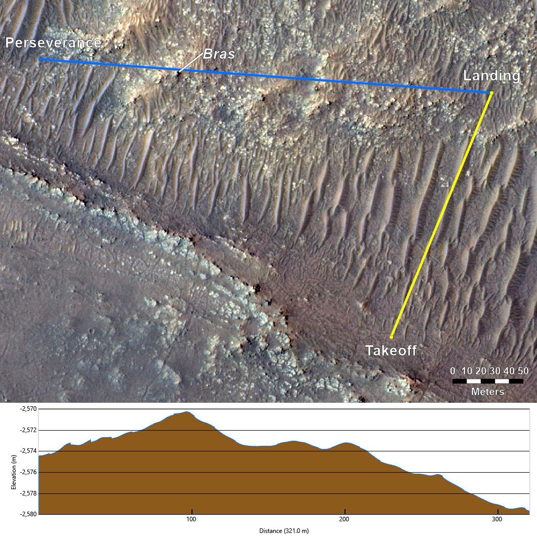
Based on the telemetry we have, the vehicle performed nominally across the board during its 117-second flight 33 feet (10 meters) above the surface of Mars. The telemetry cut out during the final third of our descent, roughly 10 feet (3 meters) off the surface. Examining how radio links behave in relation to nearby surface features can help explain why the loss of link occurred near landing.
Radio Links
A radio’s signal strength depends significantly on how clear the path, or line-of-sight (LOS), is between the transmitter and receiver antennas. That path can be obstructed by the ground itself if the helicopter lands in a depression or on the other side of a hill, or it can be obstructed by elements of the rover’s structure if the helicopter happens to be on the rover’s port (left) or stern (back) side. In this case not only was Ingenuity challenged with communicating across the rover’s structure and Multi-Mission Radioisotope Thermoelectric Generator (MMRTG) (see red LOS vector in graphic of rover), but it was also tasked with flying to a landing site which placed a 13-foot (4 meter) hill called “Bras” (named after a commune in France). in the LOS between the two antennas. With a cruise altitude of 33-feet (10 meters), Bras presented little obstruction to our radio link during the majority of the flight. But as Ingenuity began to descend, the line of sight between the rover and helicopter antennas began to become obstructed/shadowed by Bras.
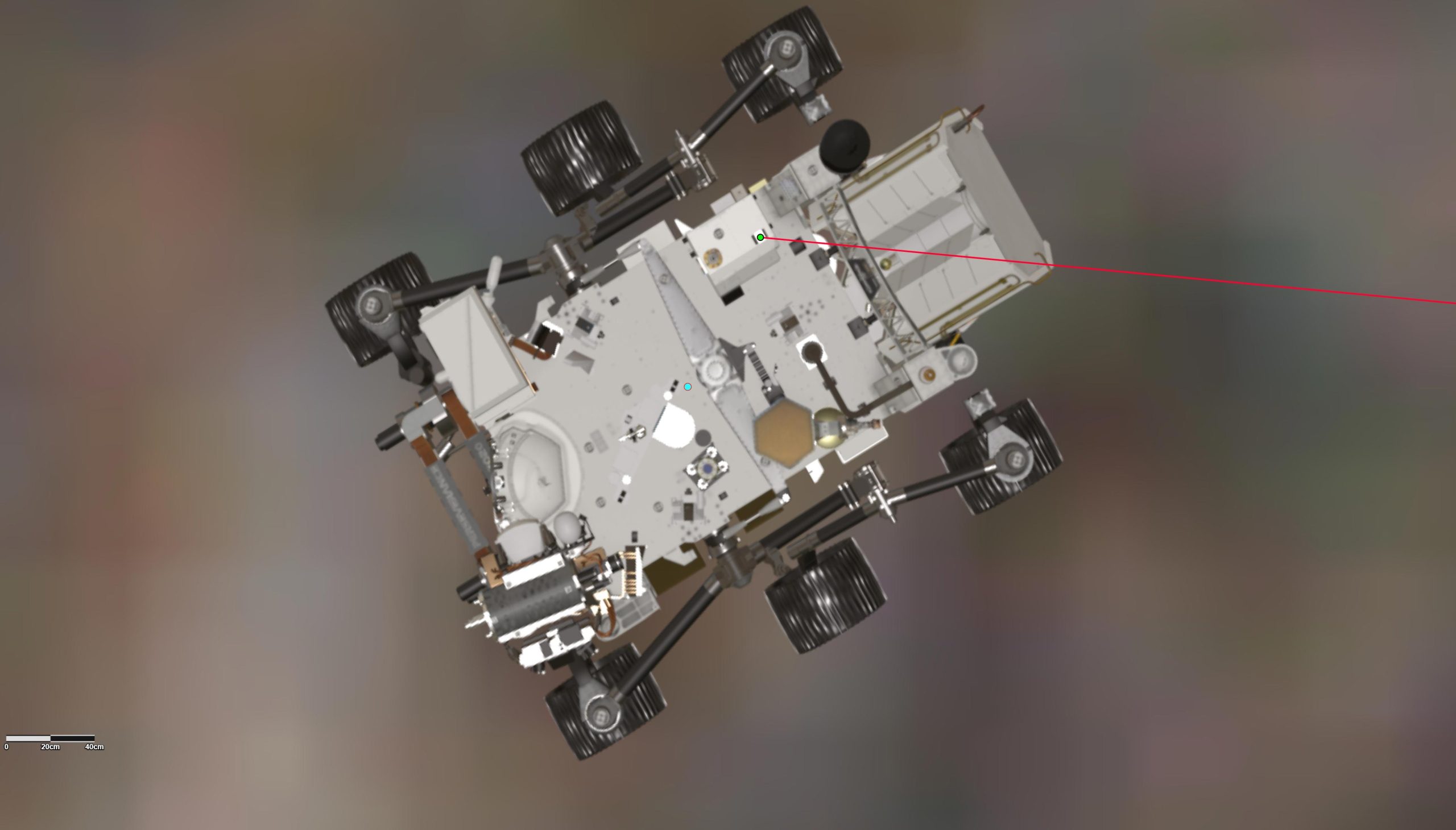
When we originally planned Flight 17, we believed that the rover was going to be parked in a specific location and oriented in a certain direction. However, Perseverance’s plans change day to day to maximize overall science return. By the time Flight 17 was ready for execution, Perseverance had driven to a new location and parked along a challenging heading for radio communications (the red LOS in Figure 2).
Since the start of the helicopter’s operations demonstration, we have accepted the potential for radio loss on landing due to the nature of our more challenging flights. Ingenuity was designed to handle these situations by automatically powering down after a flight and awaiting further instructions on subsequent sols, which we expect to be the case following Flight 17. These challenges are part of the lessons learned in integrating aerial exploration activities within the complexity of daily rover operations.
Flight Assessment
We believe the flight was a success because nothing in what we see from the available helicopter suggests otherwise. Telemetry is nominal leading right up to the moment that the radio link halted.
Even more telling are the data packets received 15 minutes after the time landing should have occurred. These packets included samples of our battery voltage indicating a +76 millivolts, or a +1.2% state-of-charge increase over 15 minutes. In other words, the battery was being charged by the helicopter’s solar array. This high level of battery charging could only be possible with an upright vehicle, with its solar array pointing to the Martian sky.
Next Steps
The first opportunity to downlink the missing data from Flight 17 will be no earlier than Wednesday, after which the team will finalize its health assessment. This flight was designed to continue our journey back to the “Octavia E. Butler” landing site by flying halfway across “South Séíitah.” We are planning on Flight 18 to occur in the next two weeks, which would bring Ingenuity another ~200 meters northeast, just shy of the northern edge of S. Séítah.
As Ingenuity ventures farther and dares mightier flights in the future, we expect to again encounter loss of radio link on landing, similar to what occurred on Sunday. We will do all that we can in planning to prevent them (when possible), but temporary loss of radio link is a natural part of helicopter operations at the Red Planet.
Written by Teddy Tzanetos, Ingenuity Team Lead at NASA’s Jet Propulsion Laboratory.
Never miss a breakthrough: Join the SciTechDaily newsletter.
Follow us on Google and Google News.
2 Comments
Amazing is all I can say.
In other words, the teams had a fubar moment. But as they write, this will happen as they separate the two missions.