An unexpected river under the Antarctic ice sheet affects the flow and melting of ice, potentially accelerating ice loss as the climate warms.
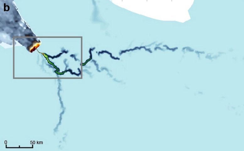
New research reveals a river deep under the ice in Antarctica that is 285 miles (460 km) long, making it longer than the River Thames. The study details how it collects water at the base of the Antarctic ice sheet from an area the size of Germany and France combined. Its discovery shows the base of the ice sheet has more active water flow than previously thought, which could make it more susceptible to changes in climate.
Details of the discovery, which was made by researchers at Imperial College London, the University of Waterloo, Canada, Universiti Malaysia Terengganu, and Newcastle University, were recently published in the journal Nature Geoscience.
Connections Between Antarctic Lakes and Rivers
Co-author Professor Martin Siegert, from the Grantham Institute at Imperial College London, said: “When we first discovered lakes beneath the Antarctic ice a couple of decades ago, we thought they were isolated from each other. Now we are starting to understand there are whole systems down there, interconnected by vast river networks, just as they might be if there weren’t thousands of meters of ice on top of them.
“The region where this study is based holds enough ice to raise the sea level globally by 4.3m. How much of this ice melts, and how quickly, is linked to how slippery the base of the ice is. The newly discovered river system could strongly influence this process.”
Origins of Subglacial Water Flow
There are two main ways water can appear beneath ice sheets: from surface meltwater running down through deep crevasses, or by melting at the base, caused by the natural heat of the Earth and friction as the ice moves over land.
However, the ice sheets around the north and south poles have different characteristics. In Greenland, the surface experiences strong melting over the summer months, where immense amounts of water channel down through deep crevasses called moulins.
In Antarctica, however, the surface doesn’t melt in sufficient quantities to create moulins, as the summers are still too cold. It was thought this meant that there was relatively little water at the base of the Antarctic ice sheets.
The new discovery turns this idea on its head, showing there is sufficient water from basal melt alone to create huge river systems under kilometers-thick ice.
The discovery was made through a combination of airborne radar surveys that allow researchers to look beneath the ice and modeling of the ice sheet hydrology. The team focused on a largely inaccessible and understudied area that includes ice from both the East and West Antarctic Ice Sheets and reaches the Weddell Sea.
Implications for Ice Loss and Sea Level
That such a large system could be undiscovered until now is a testament to how much we still need to learn about the continent, says lead researcher Dr. Christine Dow from the University of Waterloo.
She said: “From satellite measurements, we know which regions of Antarctica are losing ice, and how much, but we don’t necessarily know why. This discovery could be a missing link in our models. We could be hugely underestimating how quickly the system will melt by not accounting for the influence of these river systems.
“Only by knowing why ice is being lost can we make models and predictions of how the ice will react in the future under further global heating, and how much this could raise global sea levels.”
For example, the newly discovered river emerges into the sea beneath a floating ice shelf – where a glacier extending out from the land is buoyant enough to begin floating on the ocean water. The freshwater from the river however churns up warmer water towards the bottom of the ice shelf, melting it from below.
Interconnected Ice-Ocean Systems
Co-author Dr. Neil Ross, from the University of Newcastle, said: “Previous studies have looked at the interaction between the edges of ice sheets and ocean water to determine what melting looks like. However, the discovery of a river that reaches hundreds of kilometers inland driving some of these processes shows that we cannot understand the ice melt fully without considering the whole system: ice sheet, ocean, and freshwater.”
The existence of large under-ice rivers also needs to be taken into account when predicting the possible consequences of climate change in the region. For example, if summers warm enough to cause enough surface melt that the water reaches the base of the ice sheet, it could have large effects on the river systems, potentially tipping Antarctica to a Greenland-like state, where ice loss is much faster.
There are also potential feedback loops that would accelerate ice loss. For example, if the ice starts to flow faster as water accumulated at the base, then this will increase friction where the ice runs over dry land, which could increase the amount of basal melting and water produced.
The team is now looking to gather more data about all these mechanisms from surveys to apply their models to other regions and provide a better understanding of how a changing Antarctica could change the planet.
Reference: “Antarctic basal environment shaped by high-pressure flow through a subglacial river system” by C. F. Dow, N. Ross, H. Jeofry, K. Siu and M. J. Siegert, 27 October 2022, Nature Geoscience.
DOI: 10.1038/s41561-022-01059-1
Never miss a breakthrough: Join the SciTechDaily newsletter.
Follow us on Google and Google News.
1 Comment
“… there is sufficient water from basal melt alone to create huge river systems under kilometers-thick ice.”
It should be obvious that if that water is the result of geothermal heat and/or frictional heat, what is happening in the atmosphere, or even in the oceans, will have no effect on the amount of melt-water.
What we normally consider to be “friction” is the interference between microscopic projections on a smooth, planar surface. These projections are either sheared off or deformed, generating heat. At a larger scale, the basal-surface topography presents barriers to the movement of ice. What typically happens is that the ice either diverts around or over obstacles, or just shears over the obstacles. It is obvious from the lede illustration that the water is flowing in a typical dendritic, tributary river system, which is bounded by divides of unspecified elevation. Therefore, the idea that basal water will speed up the ice movement has little support as the dominant basal ‘friction’ will be determined by the shear strength of the ice where it passes over the ridges, well removed from the water in the river valleys.
It would seem that these researchers, like so many aboard the climatology band-wagon, have either never read T. C. Chamberlain’s “Method of Multiple Working Hypotheses (1890), or haven’t grasped how essential the approach is to finding the Truth. They are like the proverbial handy man whose only tool is a hammer, and thus, sees all problems as a nail.