Researchers used satellite data to calculate the depth of water in this transient freshwater body.
California’s Death Valley, the driest place in North America, has hosted an ephemeral lake since late 2023. A NASA-led analysis recently calculated water depths in the temporary lake over several weeks in February and March 2024, demonstrating the capabilities of the U.S.-French Surface Water and Ocean Topography (SWOT) satellite, which launched in December 2022.
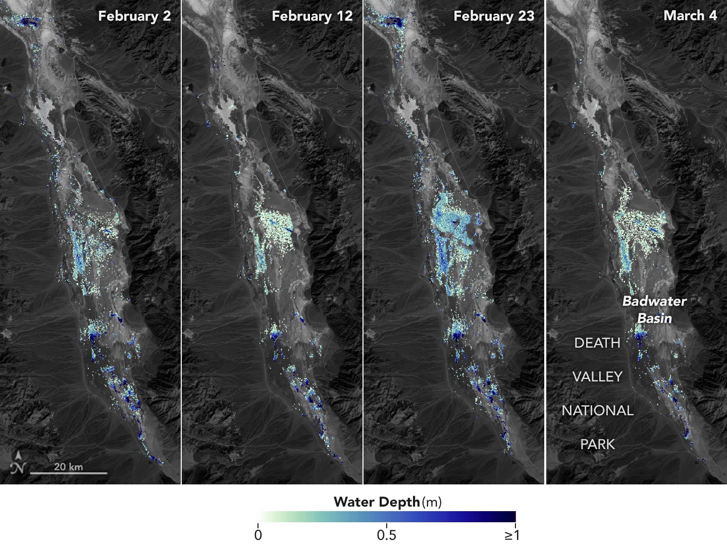
The analysis found that water depths in the lake ranged from about 3 feet (1 meter) to less than 1.5 feet (0.5 meters) over the course of about six weeks. This period included a series of storms that swept across California, bringing record amounts of rainfall.
Tracking Changes in Lake Manly
The series of images (above) and animation (below), based on data from SWOT, show some of these changes in the lake’s water depth. Deeper areas are blue, and shallower areas are yellow.
To estimate the depth of the lake, known informally as Lake Manly, researchers used water level data collected by SWOT and subtracted corresponding U.S. Geological Survey land elevation information for Badwater Basin.
Animation based on data from the Surface Water and Ocean Topography (SWOT) satellite, shows changes in the water depth of the ephemeral lake in California’s Death Valley. Deeper areas are blue, and shallower areas are yellow.
The researchers found that the water levels varied across space and time in the roughly 10-day period between SWOT observations. Right after a series of storms in early February, the temporary lake was about 6 miles (10 kilometers) long and 3 miles (5 kilometers) wide. Each pixel in the image represents an area that is about 330 feet by 330 feet (100 meters by 100 meters).
Technological Advances and Research Opportunities
“This is a really cool example of how SWOT can track how unique lake systems work,” said Tamlin Pavelsky, the NASA freshwater science lead for SWOT and a hydrologist at the University of North Carolina, Chapel Hill.
Unlike many lakes around the world, Death Valley’s lake is temporary and relatively shallow, and strong winds are enough to move the freshwater body a couple of miles, as happened from February 29 to March 2. Since there isn’t typically water in Badwater Basin, researchers don’t have permanent instruments in place for studying water in this area. SWOT can fill the data gap for when places like this, and others around the world, become inundated.
Since shortly after launch, SWOT has been measuring the height of nearly all water on Earth’s surface, developing one of the most detailed and comprehensive views of the planet’s oceans and freshwater lakes and rivers. Not only can the satellite detect the extent of water, as other satellites can, but SWOT is also able to measure water surface levels. Combined with other types of information, SWOT measurements can yield water depth data for inland features like lakes and rivers.
The SWOT science team makes its measurements using the Ka-band Radar Interferometer (KaRIn) instrument. With two antennas spread 33 feet (10 meters) apart on a boom, KaRIn produces a pair of data swaths as it circles the globe, bouncing radar pulses off water surfaces to collect surface-height information.
“We’ve never flown a Ka-band radar like the KaRIn instrument on a satellite before,” said Pavelsky, so the data represented by the graphic above is also important for scientists and engineers to better understand how this kind of radar works from orbit.
NASA Earth Observatory image by Lauren Dauphin, using SWOT data provided by the SWOT science team and Landsat data from the U.S. Geological Survey.
Never miss a breakthrough: Join the SciTechDaily newsletter.
Follow us on Google and Google News.
2 Comments
“radar pulses off water surfaces” – OR are they bouncing those pulses off everything down here- is that really something to ignore or are we going to find out in 20 years that all those pulses are also causing unrecognized effects on humans ??? We seem to always be late to the discovery of what we are doing to ourselves !
Since Death Valley is below sea level it would make an excellent place to store a portion of the Pacific Ocean Salt Water so the Sun can evaporate 13 feet of water depth per year to add the rainfall, and snowfall in the Rockies by increasing precipitation
East of that location. This would be one of several low elevation basins that would need to be filled to get an additional 4,000 to 5,000 square miles of evaporation surface area required to fill up Lake Powell, and Lake Mead. If you go back into the geologic history, that is exactly what mother nature did with Lake Bonneville, and a lake upstream of the Grand Canyon before it head cut, and emptied that lake. There were thousands of square miles of evaporation surface areas, and, used the hydrologic cycle to recycle the water over and over in the southwest US. More water, more trees, a slightly cooler climate, more snowfall, longer to melt, more water in the reservoirs.