Huge understory fires are spreading throughout the state in northern Brazil as drought and heat turn the rainforest into tinder.
Roraima—Brazil’s northernmost state—has a wet climate, which helps rainforests thrive and suppresses the natural occurrence of forest fires, even during the dry season. Nonetheless, remote sensing scientists have observed fires in this northern Amazon region for as long as satellite observations have been available, especially during the drier months of October through March. Most are management fires, ignited for purposes such as burning pastures and agricultural areas or clearing rainforest.
Recent Intense Fire Activity
In the second half of February 2024, NASA satellites observed unusually widespread and intense fire activity in Roraima, according to multiple fire monitoring platforms, including the SERVIR Amazon Fire Dashboard, the Brazilian Space Agency’s Queimadas program, and NASA’s Fire Information for Resource Management System (FIRMS).
On several occasions, satellites observed thick plumes of smoke blanketing much of Roraima. In recent decades, forested landscapes in this fast-changing state have become increasingly fragmented by new roads, pastures, and farmland as cities such as Boa Vista, Caracaraí, and Rorainópolis have expanded.
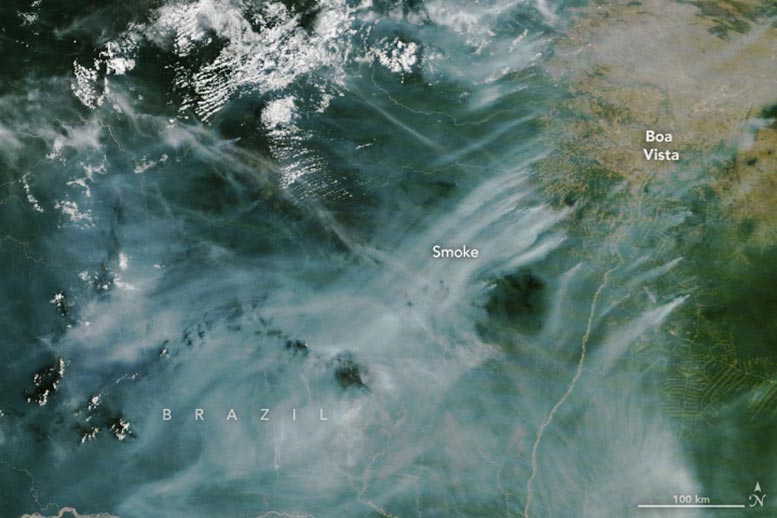
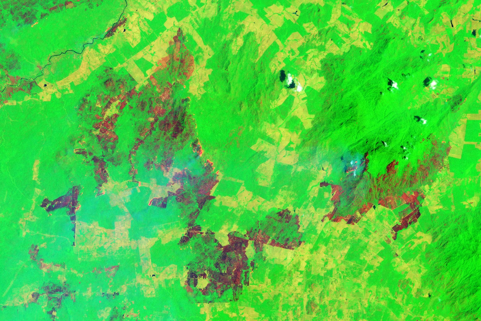
The image at the top of the page, acquired by the MODIS (Moderate Resolution Imaging Spectroradiometer) on NASA’s Terra satellite, shows smoke streaming from several fires southwest of Boa Vista on February 22, 2024. The false-color (bands 7-5-2) image below, captured by the OLI-2 (Operational Land Imager-2) on Landsat 9, shows the burn scar created by a large fire burning near Boa Vista on February 23, 2024.
Satellite Observations and Environmental Impact
According to data from Brazil’s National Institute for Space Research, the MODIS on NASA’s Aqua satellite detected more than 2,057 active fires in Roraima in February 2024. That number is five times the average for February and well above the previous record of 1,347 from February 2007.
The intensity and size of many of the fires are also unusual. The European Commission’s Copernicus Atmosphere Monitoring Service (CAMS), a system based on MODIS observations from the Global Fire Assimilation System (GFAS), estimated that fires in Brazil released more than 4.1 megatons of carbon into the atmosphere in February 2024, the highest February monthly total on record since 2003. Roughly half of those carbon emissions came from the fires in Roraima.
“Most management fires you might find in this area during a normal year would cover just a few square kilometers, but we’re seeing fires this year that began in pastures or recently cleared rainforest and then spread into the surrounding rainforest areas that are burning hundreds of square kilometers,” said Shane Coffield, a postdoc at NASA’s Goddard Space Flight Center. “These are huge wildfires—and they’re devastating for the ecosystems and air quality.”
The flames of understory fires in the southern Amazon reach on average only a few feet tall, but the fire type can claim anywhere from 10 to 50 percent of a burn area’s trees. Credit: NASA/Doug Morton
For comparison, 100 square kilometers is about 30 times the size of Central Park in New York City. Forest fires in this area burn in the rainforest understory without fully consuming the canopy, but they can harm rainforests by killing a large percentage of trees and causing damage that persists for decades.
Since Amazon forest fires occur under the canopy, they can be difficult for satellite sensors like MODIS or VIIRS (Visible Infrared Imaging Radiometer Suite) to detect. Orbiting sensors with higher spatial resolution, such as the OLI (Operational Land Imager) or OLI-2 on Landsat 8 or 9 and the MSI (Multi Spectral Instrument) on Sentinel-2, can help because they can more easily detect the signature of fire through gaps in the canopy.
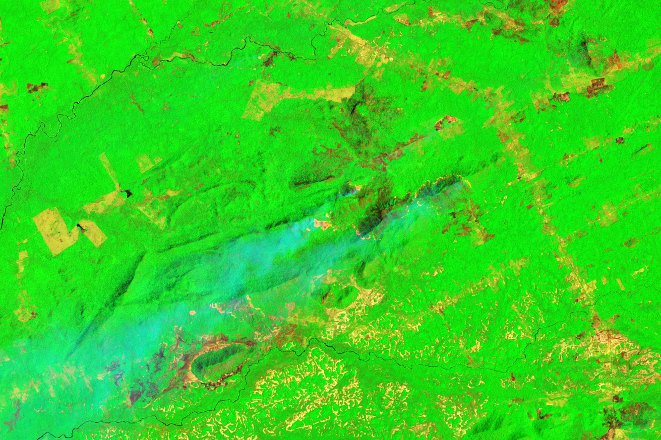
The false-color image below shows an understory fire that burned widely in the rainforest (green) after escaping from a pasture (yellow) along the BR-432 road near Vila Nova Paraiso. Active fire fronts appear orange, and burned areas are brown. The image was acquired by the OLI on Landsat 8 on February 23, 2024.
“The situation is critical here,” said Haron Abrahim Magalhães Xaud, a remote sensing researcher at the Brazilian Agricultural Research Corporation (Embrapa) in Boa Vista. “We’ve broken the monthly record for total satellite detections of fire since the start of the MODIS record in 2000, and the government of Roraima has declared a state of emergency in nine municipalities due to drought and forest fires.”
Outbreaks of fire at this scale and intensity are typically exacerbated by weather and climate conditions, and this year is no exception. Severe drought has plagued the Amazon Basin since mid-2023, partly because the ongoing El Niño simmering in the Pacific has shifted rainfall away from this area. Drought is also severe because human-caused global warming has added extra heat to the region and helped create conditions where fires can flourish and spread rapidly.
“Amazon regions like Roraima that receive less rainfall during an El Niño year are poised to have longer and stronger dry seasons, increasing the risk that management fires spread out of control and burn into the rainforest,” said Douglas Morton, an earth scientist at NASA Goddard. Extreme fire activity in the northern Amazon early in the calendar year is typically followed by an uptick in fire activity in the southern Amazon in July through September, often months after the end of El Niño conditions in the tropical Pacific Ocean, he added.
Challenges in Fire Detection and Future Prospects
As conditions change across the Amazon, earth scientists and fire managers in Brazil and around the world will be tracking Amazon fire activity using tools powered by satellite observations. “I check FIRMS, the SERVIR Amazon Fire Dashboard, INPE’s BD-Queimadas, and the CENSIPAM Fire Dashboard (Painel do Fogo) every day,” Xaud said. “The advantage of the SERVIR and CENSIPAM dashboards is that they provide event-level information, making it easier to visualize and track individual fires.”
Morton and Coffield are not only tracking the latest fire activity using existing tools. They’re also in the process of trying to build even better ones. Coffield is currently refining fire detection techniques and working on a new visualization tool—a prototype is available here—based on Landsat 8 & 9 and Sentinel-2 observations that the scientists hope will eventually make it easier to identify understory forest fires and make it easier to rapidly distinguish between fire types.
NASA Earth Observatory images by Wanmei Liang, using MODIS data from NASA EOSDIS LANCE and GIBS/Worldview and Landsat data from the U.S. Geological Survey.
Never miss a breakthrough: Join the SciTechDaily newsletter.
Follow us on Google and Google News.