
NASA’s EMIT instrument, originally designed to study minerals in deserts, is now uncovering signs of sewage pollution along the Southern California coast, from 250 miles above Earth.
In a new study, researchers used EMIT’s hyperspectral imaging to detect cyanobacteria pigments in a massive wastewater plume at the Tijuana River’s mouth. The discovery demonstrates how this space-based technology can pinpoint harmful contaminants that traditional satellite tools often miss. By matching its spectral data with on-the-ground testing, scientists found compelling evidence of pollution that poses health risks to both humans and marine life.
NASA’s EMIT Instrument Spots Sewage From Space
A NASA instrument originally designed to study minerals on land is now uncovering hidden threats in the ocean. Scientists have discovered that EMIT — short for Earth Surface Mineral Dust Source Investigation — can also detect signs of sewage in coastal waters. In a recent study, EMIT identified pollution near a Southern California beach with surprising clarity.
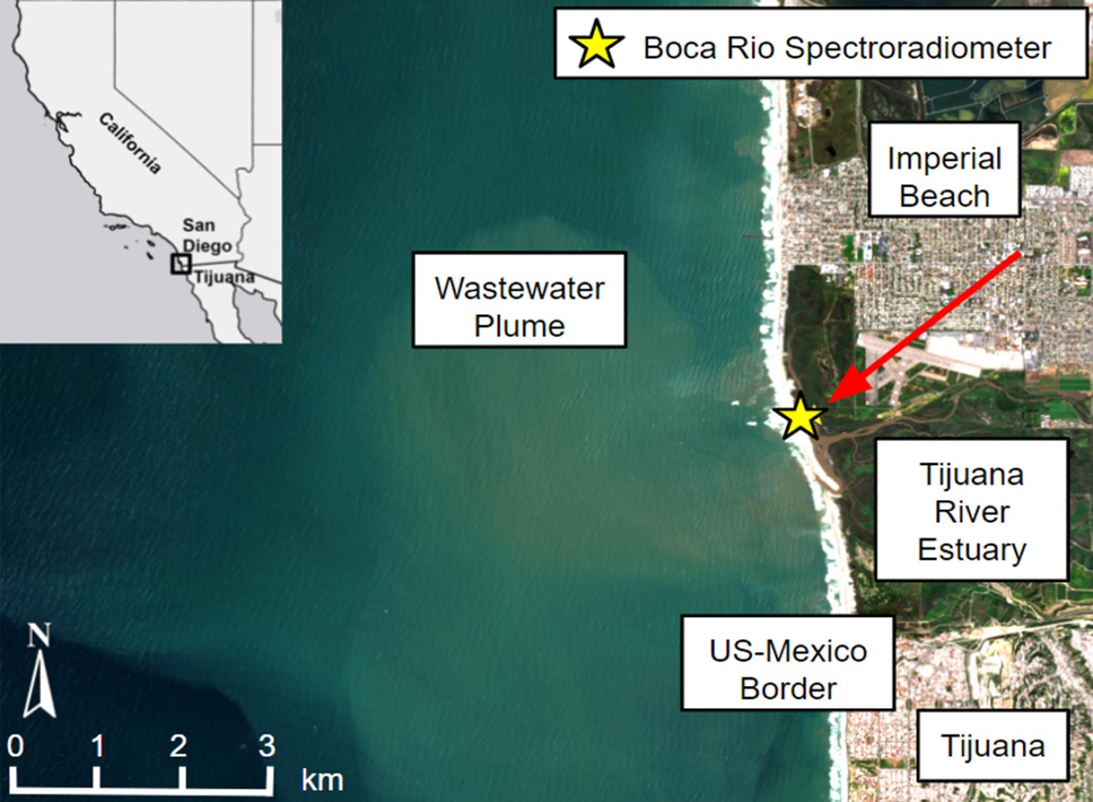
The research focused on a large plume of wastewater flowing from the Tijuana River, just south of Imperial Beach near San Diego. Every year, millions of gallons of treated and untreated sewage travel down this river, crossing the U.S.-Mexico border and passing through communities and a protected natural reserve before reaching the Pacific Ocean. This polluted water can pose serious health risks to swimmers and surfers, as well as U.S. Navy trainees. It also threatens marine life, fisheries, and the broader coastal ecosystem.
Why Traditional Satellites Miss the Full Picture
For decades, scientists have used satellites to track ocean health, such as harmful algal blooms, by analyzing changes in water color. Vibrant shades of red or green often signal the presence of algae or phytoplankton. But many harmful bacteria and pollutants don’t show up clearly, making them harder to detect with traditional tools.
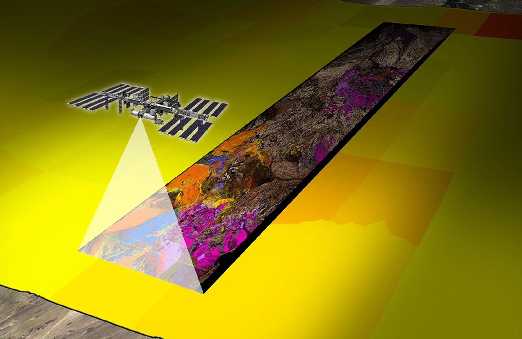
EMIT is different. This advanced hyperspectral sensor orbits Earth on the International Space Station and captures sunlight reflected off the planet. Its optics split the light into hundreds of distinct color bands, far more than typical satellites. By examining these bands pixel by pixel, scientists can identify the specific “fingerprints” of different molecules.
Scientists compared EMIT’s observations of the Tijuana River plume with water samples they tested on the ground. Both EMIT and the ground-based instruments detected a spectral fingerprint pointing to phycocyanin, a pigment in cyanobacteria, an organism that can sicken humans and animals that ingest or inhale it.
‘Smoking Gun’
Many beachgoers are already familiar with online water-quality dashboards, which often rely on samples collected in the field, said Christine Lee, a scientist at JPL in Southern California and a coauthor of the study. She noted the potential for EMIT to complement these efforts.
“From orbit, you are able to look down and see that a wastewater plume is extending into places you haven’t sampled,” Lee said. “It’s like a diagnostic at the doctor’s office that tells you, ‘Hey, let’s take a closer look at this.’”
Lead author Eva Scrivner, a doctoral student at the University of Connecticut, said that the findings “show a ‘smoking gun’ of sorts for wastewater in the Tijuana River plume.” Scrivner, who led the study while at San Diego State University, added that EMIT could be useful for filling data gaps around intensely polluted sites where traditional water sampling takes a lot of time and money.
EMIT’s Expanding Role Beyond Dry Land
The technology behind EMIT is called imaging spectroscopy, which was pioneered at JPL in the 1980s. Imaging spectrometers developed at JPL over the decades have been used to support areas ranging from agriculture to forest health and firefighting.
When EMIT was launched in July 2022, it was solely aimed at scitechdaily The data we’re getting from EMIT will give us more insight into the heating and cooling of Earth, and the role mineral dust plays in that cycle and dust in Earth’s desert regions. That same sensitivity enabled it to spot the phycocyanin pigments off the California coast.
Scrivner hadn’t anticipated that an instrument initially devoted to exploring land could reveal insights about water. “The fact that EMIT’s findings over the coast are consistent with measurements in the field is compelling to water scientists,” she said. “It’s really exciting.”
Reference: “Hyperspectral characterization of wastewater in the Tijuana River Estuary using laboratory, field, and EMIT satellite spectroscopy” by Eva Scrivner, Natalie Mladenov, Trent Biggs, Alexandra Grant, Elise Piazza, Stephany Garcia, Christine M. Lee, Christiana Ade, Nick Tufillaro, Philipp Grötsch, Omar Zurita, Benjamin Holt and Daniel Sousa, 8 May 2025, Science of The Total Environment.
DOI: 10.1016/j.scitotenv.2025.179598
Never miss a breakthrough: Join the SciTechDaily newsletter.
Follow us on Google and Google News.
3 Comments
“When EMIT was launched in July 2022, it was solely aimed at scitechdaily [sic] The data we’re getting from EMIT …”
What was this supposed to say?
“This ADVANCED hyperspectral sensor orbits Earth on the International Space Station and captures sunlight reflected off the planet.”
How does EMIT differ from the AVIRIS instrument first flown in the 1980s?
When NASA’s Earth Surface Mineral Dust Source Investigation (EMIT) was launched in July 2022, it was solely aimed at mapping the mineral composition of Earth’s arid dust source regions. The primary goal was to better understand how mineral dust affects the Earth’s climate, specifically its heating and cooling effects.
This involved:
Mapping where the dust originates and its composition.
Providing data to improve computer models that assess the regional and global heating and cooling effects of mineral dust.
Predicting how future climate scenarios might change the amount and type of mineral dust emitted into the atmosphere.
However, EMIT has since demonstrated capabilities beyond its initial scope, such as:
Detecting wastewater plumes and monitoring coastal pollution.
Identifying point-source emissions of methane and carbon dioxide.
Supporting diverse research projects in areas like agriculture, hydrology, and climate science.
Thank for for the corrected text. However, I’m still curious about “How does EMIT differ from the AVIRIS instrument first flown in the 1980s?”