Ancient floods once ripped across Mars, carving the massive Shalbatana Vallis channel and reshaping the planet’s surface. New Mars Express images reveal a chaotic landscape of craters, lava, and collapsed terrain that may hold clues to a lost Martian ocean.
ESA’s Mars Express mission is highlighting Shalbatana Vallis this month, a striking Martian valley shaped by ancient floods and surrounded by signs of volcanic activity, impact craters, and collapsed terrain.
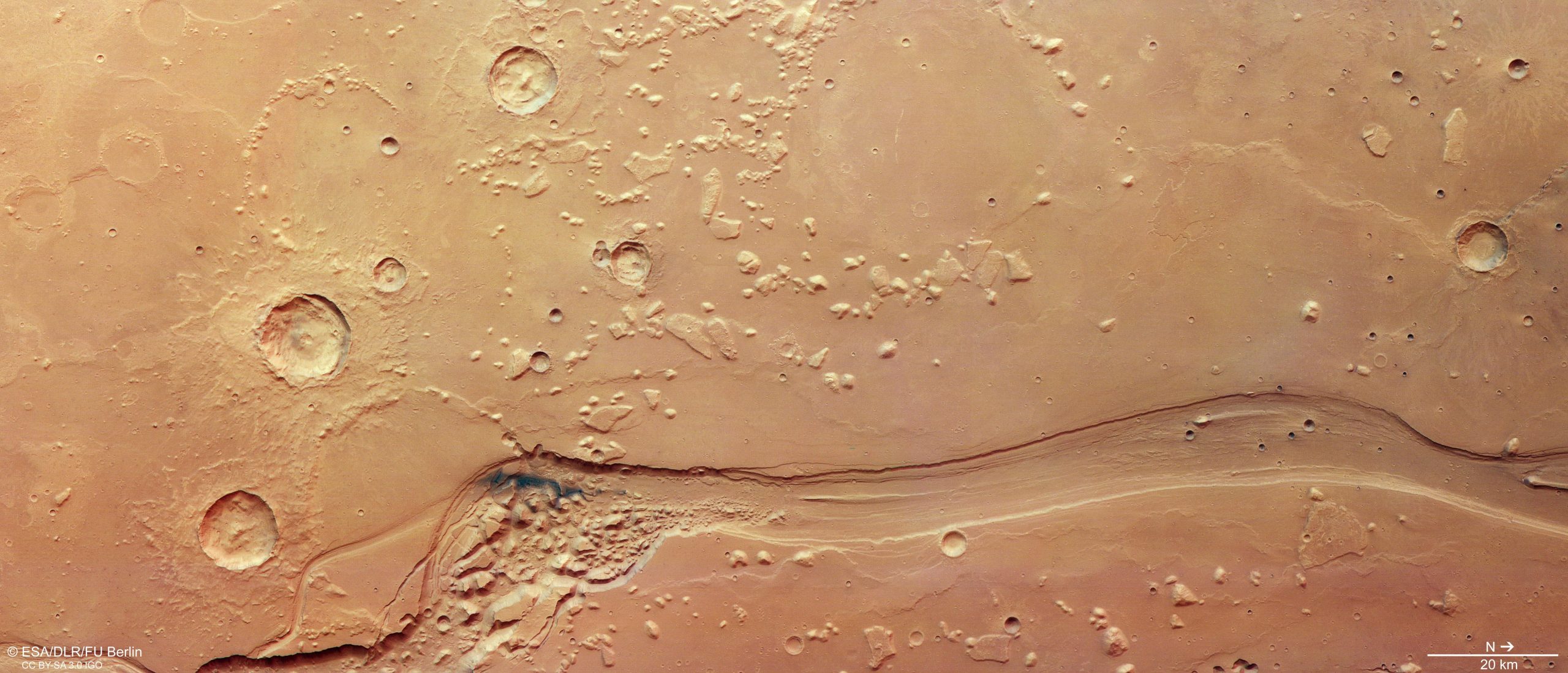
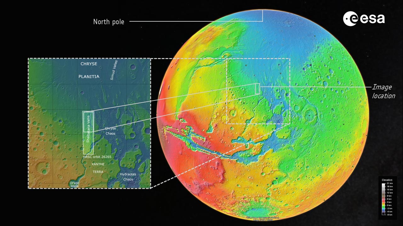
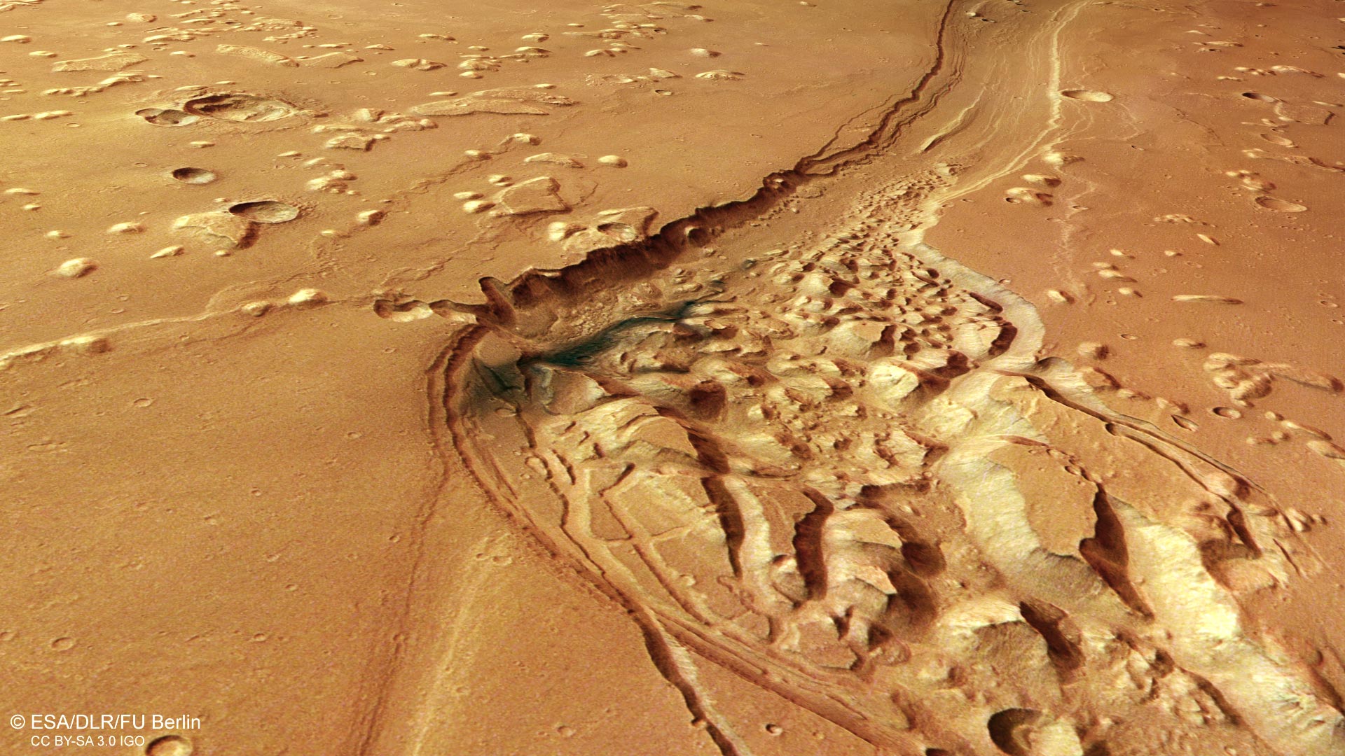
Situated near the equator of Mars, Shalbatana Vallis stretches across the planet for roughly 1,300 kilometers, about the same length as Italy. The latest image from Mars Express’s High Resolution Stereo Camera (HRSC) focuses on the northern section of the channel as it winds through the dusty Martian surface.
In October 2025, ESA also released a Mars Express video tour of this region (see video below), tracing the valley from its starting point in the highlands of Xanthe Terra to its endpoint in the smoother plains of Chryse Planitia.
Ancient Floods Carved a Giant Martian Valley
Scientists believe Shalbatana Vallis formed around 3.5 billion years ago when massive amounts of groundwater burst upward from beneath Mars’s surface. Those powerful floods rapidly eroded the landscape, carving deep channels as the water rushed downhill.
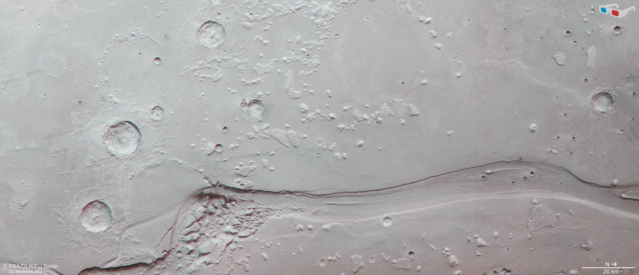
The main valley seen in the image enters from the lower left corner and curves northward out of frame on the right. It measures around 10 kilometers wide and reaches depths of about 500 meters, features shown most clearly in the accompanying topographic view (below).
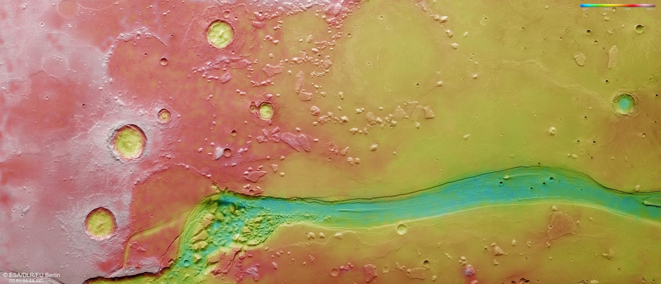
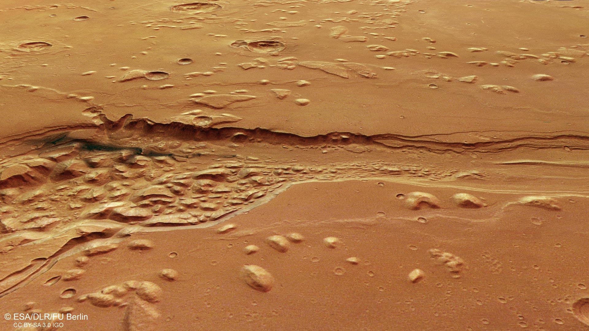
Researchers think the valley was once deeper than it appears today. Over time, sediments and other materials partially filled the channel. One especially dark blue-black patch visible in the rougher section of the valley is thought to be volcanic ash later redistributed by Martian winds, as shown in the accompanying 3D perspective views (below, and further down).
Clues to Water and a Possible Ancient Ocean
Shalbatana Vallis is part of a broader network of outflow channels in this region of Mars. The area marks the boundary between the heavily cratered southern highlands (to the left) and the smoother northern lowlands (right).
Just beyond the image lies Chryse Planitia, one of the lowest regions on Mars (see map below). Many of the planet’s major outflow channels terminate there, leading some scientists to propose that Chryse Planitia may once have contained a large ocean during an earlier era when Mars was warmer and wetter.
Chaotic Terrain, Lava, and Craters
The landscape surrounding Shalbatana Vallis contains a variety of additional geological features, all labeled in the annotated version of the image.
Outflow channels on Mars are commonly associated with so-called chaotic terrain, a jumbled landscape made up of broken blocks, ridges, and rocky mounds. In this region, chaotic terrain appears in the wider section of Shalbatana Vallis near the dark volcanic ash deposits (see below).
Scientists think these formations developed when underground ice melted beneath the surface, causing the ground above to shift and collapse. Similar chaotic terrain has previously been observed by Mars Express in regions including Pyrrhae Regio, Iani Chaos, Ariadnes Colles, Aram Chaos, and Hydraotes Chaos.
Numerous impact craters are also visible throughout the area. Some have been partly buried, others have eroded over time, and several remain surrounded by debris blasted outward during the original impacts.
Much of the surrounding terrain appears relatively smooth, suggesting that lava once flowed across the region. As the lava cooled and contracted, it folded into uneven features known as ‘wrinkle ridges’. Isolated hills called ‘mesas’ are also visible (to the upper right, for example). These are remnants of older, elevated surfaces that gradually eroded away over billions of years.
More Than 20 Years of Mars Exploration
The images were captured by the HRSC camera, one of eight scientific instruments aboard Mars Express. Since launching in 2003, the spacecraft has spent more than two decades studying Mars and mapping its surface in color and in three dimensions at unprecedented detail. The mission has provided scientists with major insights into the planet’s geological history and evolution.
The Mars Express HRSC was developed and is operated by the German Aerospace Center (Deutsches Zentrum für Luft- und Raumfahrt; DLR). The camera data was systematically processed at the DLR Institute of Space Research in Berlin-Adlershof. The Planetary Science and Remote Sensing group at Freie Universität Berlin used the data to create the image products shown here.
Never miss a breakthrough: Join the SciTechDaily newsletter.
Follow us on Google and Google News.
1 Comment
MARS HAS CHANNELED SCABLANDS