Close Menu
    Facebook X (Twitter) Instagram
    SciTechDaily
    • Biology
    • Chemistry
    • Earth
    • Health
    • Physics
    • Science
    • Space
    • Technology
    Facebook X (Twitter) Pinterest YouTube RSS
    SciTechDaily
    Home»Earth»New Maps of Above Ground Biomass Is Set to Help Our Understanding of Global Carbon Cycling
    Earth

    New Maps of Above Ground Biomass Is Set to Help Our Understanding of Global Carbon Cycling

    By European Space Agency (ESA)March 21, 2021No Comments5 Mins Read
    Facebook Twitter Pinterest Telegram LinkedIn WhatsApp Email Reddit
    Share
    Facebook Twitter LinkedIn Pinterest Telegram Email Reddit
    Forest Biomass Estimates
    Newly created maps of above-ground biomass, generated from space observations, are poised to enhance our understanding of global carbon cycling.

    New ESA maps of global forest biomass help track carbon storage and support climate goals like the Paris Agreement.

    Fluctuations in the carbon-rich biomass held within the world’s forests can contribute to, or slow, climate change. A series of new maps of above ground biomass, generated using space observations, is set to help our understanding of global carbon cycling and support forest management, emissions reduction and sustainable development policy goals.

    Above ground biomass refers to the stem, bark, branches, and twigs of woody components of vegetation. As photosynthesis withdraws carbon dioxide from the atmosphere, it stores carbon in vegetation in an amount comparable to that of atmospheric carbon. The vegetation has the potential to sequester more carbon in the future or to contribute as an even larger source.

    Above Ground Biomass
    Vegetation biomass is a crucial ecological variable for understanding the evolution and potential future changes of the climate system, on a local, regional and even global scale. Credit: ESA (data source: CCI Biomass project)

    Vegetation biomass is a crucial ecological variable for understanding the evolution and potential future changes of the climate system, on a local, regional, and even global scale. For this reason, it is recognized by the Global Climate Observing System (GCOS) as one of the 54 Essential Climate Variables used to characterize climate.

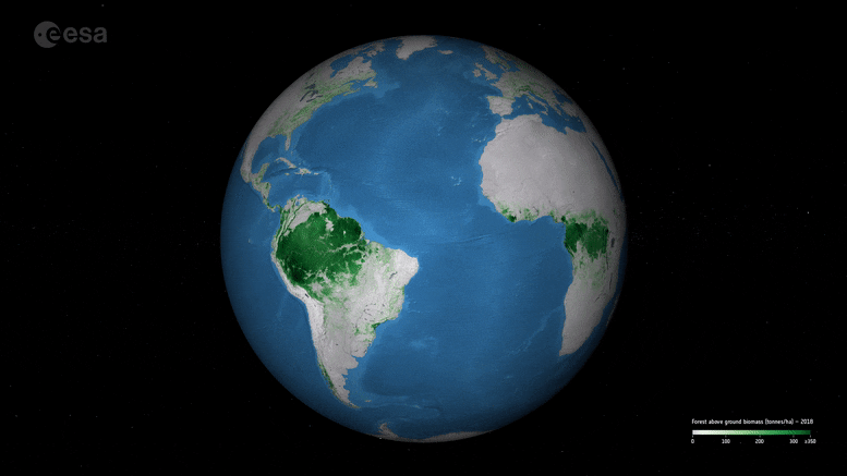
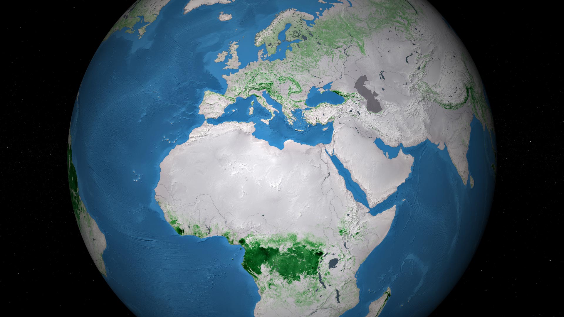
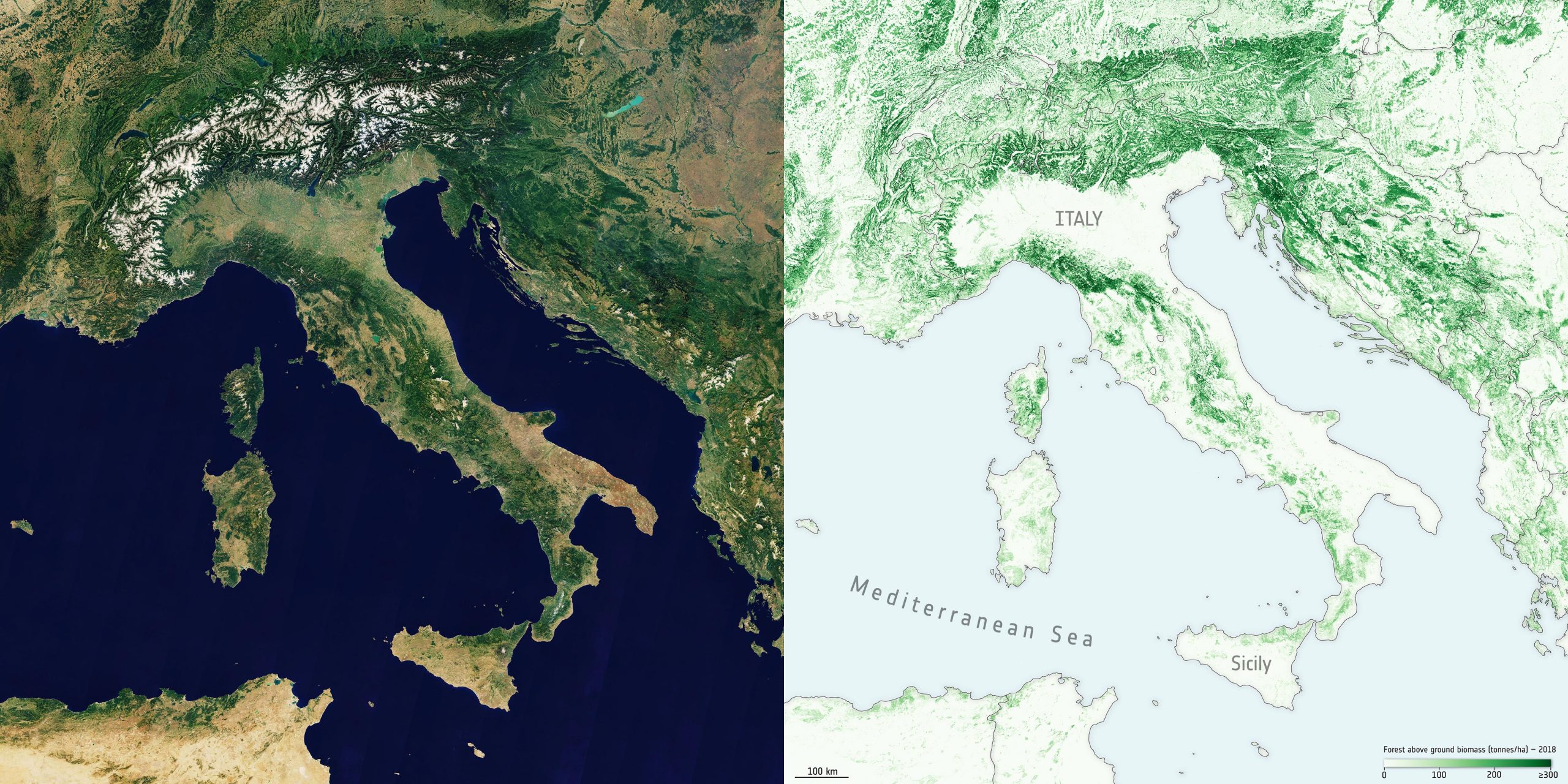
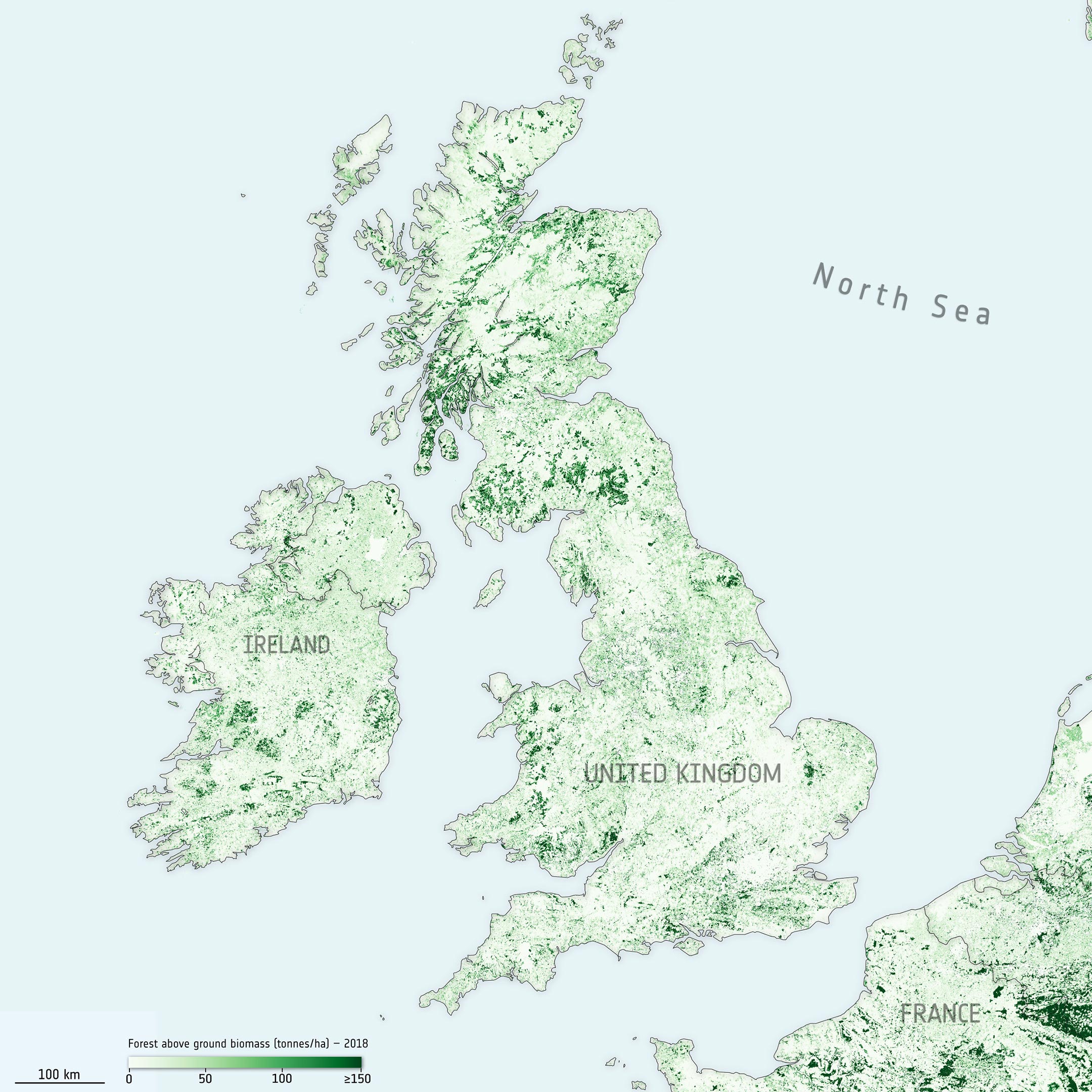
    New maps, generated by a research team working as part of ESA’s Climate Change Initiative, provide a global view of above ground biomass distribution and spatial density over three separate years – 2010, 2017, and 2018. The maps are derived from a combination of data, depending on the year, from the Copernicus Sentinel-1 mission, Envisat’s ASAR instrument, and JAXA’s Advanced Land Observing Satellite (ALOS-1 and ALOS-2), along with additional information from Earth observation sources.

    Enhancing Model Accuracy and Reducing Uncertainty

    Earth observation data are routinely used to validate the accuracy, or identify biases, in climate models. The new maps, provided at 100 m resolution, have trimmed uncertainty estimates and will help to further constrain models.

    Crucially, and according to the team’s science leader, Shaun Quegan, the new maps capture the higher biomass levels in high-density forest areas, such as in the tropics, due to major improvements to the algorithm.

    By using a globally consistent retrieval methodology, the advent of multi-year biomass maps brings the prospect of monitoring changes a step closer to reality. However, users are currently discouraged from quantifying biomass changes just by subtracting the current maps, since the retrieval procedure is still being tuned to account for the different mission and sensor observations used in their generation.

    Italy Above Ground Biomass
    Above ground biomass in Italy. The map of Italy on the right shows the above ground biomass data from 2018. The optical image on the left shows the same view of Italy and the surrounding countries and was processed using the in-house Copernicus Sentinel-2 cloudless composite. Credit: Left: contains modified Copernicus Sentinel data (2018), processed by ESA. Right: ESA (data source: CCI Biomass project using modified Copernicus Sentinel data (2018) and JAXA’s Global PALSAR-2 Mosaic (2018)

    The team is currently developing a map for 2020 while also addressing temporal consistency between the different years, with the integration of additional low geometric resolution data streams under consideration, namely L-band vegetation optical depth from ESA’s Soil Moisture and Ocean Salinity (SMOS) satellite and scatterometer data from the ASCAT on board Eumetsat’s Metop satellites.

    Shaun Quegan explains, “Combining these new data is anticipated to increase the consistency of these high-resolution maps, and move a step closer towards tracking changes and direct estimation of gross gains and losses of above ground biomass at scale.” Alternative approaches to correct for bias are also under investigation.

    United Kingdom and Ireland Above Ground Biomass
    Above ground biomass in the United Kingdom and Ireland. The map of the United Kingdom and Ireland shows the above ground biomass data from 2018. Credit: ESA (data source: CCI Biomass project using modified Copernicus Sentinel data (2018) and JAXA’s Global PALSAR-2 Mosaic (2018)

    Tracking Change and Supporting Policy

    With a decade of global biomass estimates on the horizon, the maps are set to allow scientists to undertake trend analyses, allowing, for example, the impact of regional climate phenomena such as El Niño on biomass dynamics to be better understood.

    Significantly, an ability to track global biomass change is set to support global and national policy aimed at meeting emission reduction commitments to limit global warming. Biomass estimates provide critical support for both reporting of national greenhouse emissions under the Paris Agreement and for forest management through the United Nations’ Reducing Emissions from Deforestation and Degradation-plus (REDD+) initiative.

    Tracking biomass change is also becoming increasingly important as national governments work towards reporting for the Global Stocktake – an aspect of the global Paris climate deal – that will periodically check international progress towards meeting emissions reduction commitments to limit global warming.

    Never miss a breakthrough: Join the SciTechDaily newsletter.
    Follow us on Google and Google News.

    Biomass Climate Science European Space Agency Forests Geography
    Share. Facebook Twitter Pinterest LinkedIn Email Reddit

    Related Articles

    Satellites Reveal How Forests Increase Clouds and Cool the Climate

    Russia’s Forests Store More Carbon Than Previously Thought – Estimated 3.9 Trillion Cubic Feet of Wood

    Earth From Space: Japanese Archipelago [Video]

    Earth From Space: Faroe Islands [Video]

    Earth From Space: Tromsø, Norway [Video]

    What Really Controls the Pace of Spring Snowmelt

    Jakobshavn Glacier Sheds a Massive Chunk of Ice

    CryoSat Satellite Shows Increased Volume of Arctic Sea Ice

    Satellite-Based Assessment of Ocean Acidification

    Leave A Reply Cancel Reply

    • Facebook
    • Twitter
    • Pinterest
    • YouTube

    Don't Miss a Discovery

    Subscribe for the Latest in Science & Tech!

    Trending News

    Popular Sugar-Free Sweetener Linked to Liver Disease, Study Warns

    What Is Hantavirus? The Deadly Disease Raising Alarm Worldwide

    Scientists Just Discovered How the Universe Builds Monster Black Holes

    Scientists Unveil New Treatment Strategy That Could Outsmart Cancer

    A Simple Vitamin May Hold the Key to Treating Rare Genetic Diseases

    Scientists Think the Real Fountain of Youth May Be Hiding in Your Gut

    Ravens Don’t Follow Wolves, They Predict Them

    This Common Knee Surgery May Be Doing More Harm Than Good

    Follow SciTechDaily
    • Facebook
    • Twitter
    • YouTube
    • Pinterest
    • Newsletter
    • RSS
    SciTech News
    • Biology News
    • Chemistry News
    • Earth News
    • Health News
    • Physics News
    • Science News
    • Space News
    • Technology News
    Recent Posts
    • Why Are So Many New Fathers Dying? Scientists Say the U.S. Has a Dangerous Blind Spot
    • Scientists Identify Simple Supplement That Greatly Reduces Alzheimer’s Damage
    • You May Have a Dangerous Type of Cholesterol Even if Your Tests Look Normal
    • Study Reveals Dangerous Flaw in AI Symptom Checkers
    • New MRI Breakthrough Captures Stunningly Clear Images of the Eye and Brain
    Copyright © 1998 - 2026 SciTechDaily. All Rights Reserved.
    • Science News
    • About
    • Contact
    • Editorial Board
    • Privacy Policy
    • Terms of Use

    Type above and press Enter to search. Press Esc to cancel.