
Groundwater across High Mountain Asia is rapidly declining due to combined climate and human pressures, with worsening risks ahead.
A new satellite-driven analysis reveals a sharp and ongoing decline in groundwater reserves across High Mountain Asia (HMA), often called the “Asian Water Tower.”
This vast system supplies water for farming, cities, and ecosystems across more than a dozen countries, supporting hundreds of millions of people, yet it is now losing about 24.2 billion tons of groundwater each year.
Satellite analysis reveals widespread groundwater loss
The study, led by Prof. Shudong Wang of the Aerospace Information Research Institute of the Chinese Academy of Sciences (AIRCAS), tackles long-standing challenges tied to limited data and the region’s rugged terrain. The findings were published in Environmental Research Letters.
To overcome these barriers, the researchers built an artificial intelligence (AI)-based evaluation system that combines satellite measurements from multiple sources with Earth system modeling and explainable AI methods. This approach allowed them to reconstruct changes in groundwater storage (GWS) over the past 20 years, determine the main factors driving those changes, and explore how risks may evolve in the future.
Depletion concentrates in populated basins
Results show that nearly two-thirds of High Mountain Asia experienced declining groundwater levels between 2003 and 2020. The steepest losses occurred in heavily populated river basins with intensive irrigation, including the Ganges–Brahmaputra, Indus, and Amu Darya regions. In contrast, some higher altitude inland areas showed localized increases in groundwater storage.
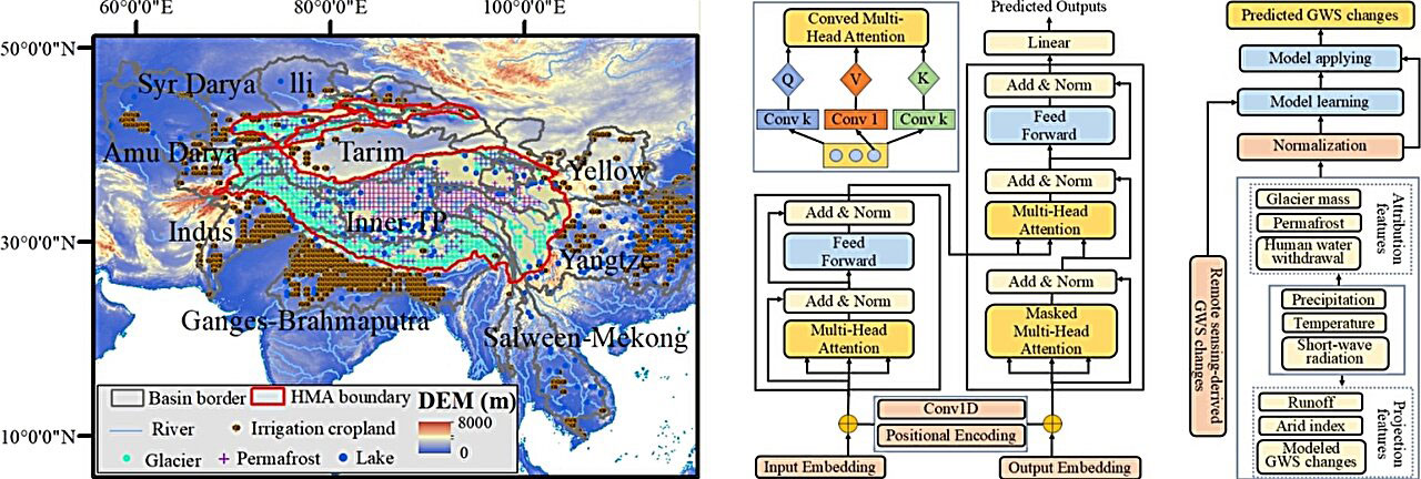
Climate-related influences explain close to half of the observed changes in GWS, with ice and snow processes playing a key role. At the same time, human water extraction, especially for irrigation in downstream areas, has become an increasingly dominant factor in groundwater loss, with its impact growing more pronounced after 2010.
Climate and water use drive decline
Future projections suggest that groundwater depletion will continue if current water use patterns remain unchanged. Meltwater from glaciers may briefly slow the rate of loss in certain regions around the 2060s, creating a temporary “buffer effect.”
However, this effect is not expected to last and could be followed by a faster drop in groundwater levels. Without changes in water management, downstream agricultural regions face increasing risk.
AI framework improves groundwater tracking
The researchers used a knowledge-guided, data-driven framework that draws on multi-sensor satellite data to map groundwater storage changes over two decades. A lightweight Transformer model was used to capture delayed hydrological responses and memory effects in mountainous systems.
Explainable machine learning tools helped link observed changes to physical processes in a consistent way. The results were validated against thousands of groundwater well observations and independent datasets, strengthening confidence in the findings.
By combining satellite remote sensing with hydrological science and interpretable AI, this framework provides a more complete view of groundwater dynamics in a region where direct measurements are limited.
Reference: “Assessing groundwater sustainability across high mountain Asia using remote sensing” by Kai Liu, Xueke Li, Yong Bo, Shudong Wang and Guangsheng Zhou, 2 January 2026, Environmental Research Letters.
DOI: 10.1088/1748-9326/ae2e1b
The research was funded by the National Key R&D Program of China and the Key Program of the National Natural Science Foundation of China (NSFC).
Never miss a breakthrough: Join the SciTechDaily newsletter.
Follow us on Google and Google News.
1 Comment
“Future projections suggest that groundwater depletion will continue if current water use patterns remain unchanged.”
That is something Captain Obvious would conclude if he gave any thought at all to the issue. It is only humans who actually USE water — or care about its availability! Without humans, groundwater accumulates in the groundwater reservoir and rises until the water table intersects the surface where it either comes out as a spring, or contributes to existing water bodies such as streams and lakes. Climatic fluctuations may cause variations in the height of the water table, but any and all surplus water that intersects the surface generally finds its way to the oceans quickly unless it is in a hydrologic basin without an outlet, such as the Great Salt Lake.
Wild animals and nomadic humans will seek out water and consume it as needed, where it is available. Once it accomplishes the bodily functions that require it, it finds its way back into the ground.
On can be sure that the available surface water will vary over time and if animals or humans exceed the carrying capacity of the land during times of drought, there will be stress on them. Thus, droughts can kill animals and humans if the carrying capacity is reduced. Humans have found ways to extend their carrying capacity by digging wells or damming rivers. But, there is a limit to such activities. Primitive humans more typically migrate until they find available surface water. Humans have to accept that we have already exceeded the carrying capacity of the land without technological intervention, which requires energy and invariably has unintended consequences.
Humans have to find ways to reduce their fecundity, preferably by means other than warfare. Water availability has always varied over time, and always will.