Perth is vividly captured in a photograph taken from the International Space Station.
Perth, the only city along the country’s western coastline with more than 1 million people, displays widespread urban infrastructure alongside the Swan and Canning rivers.
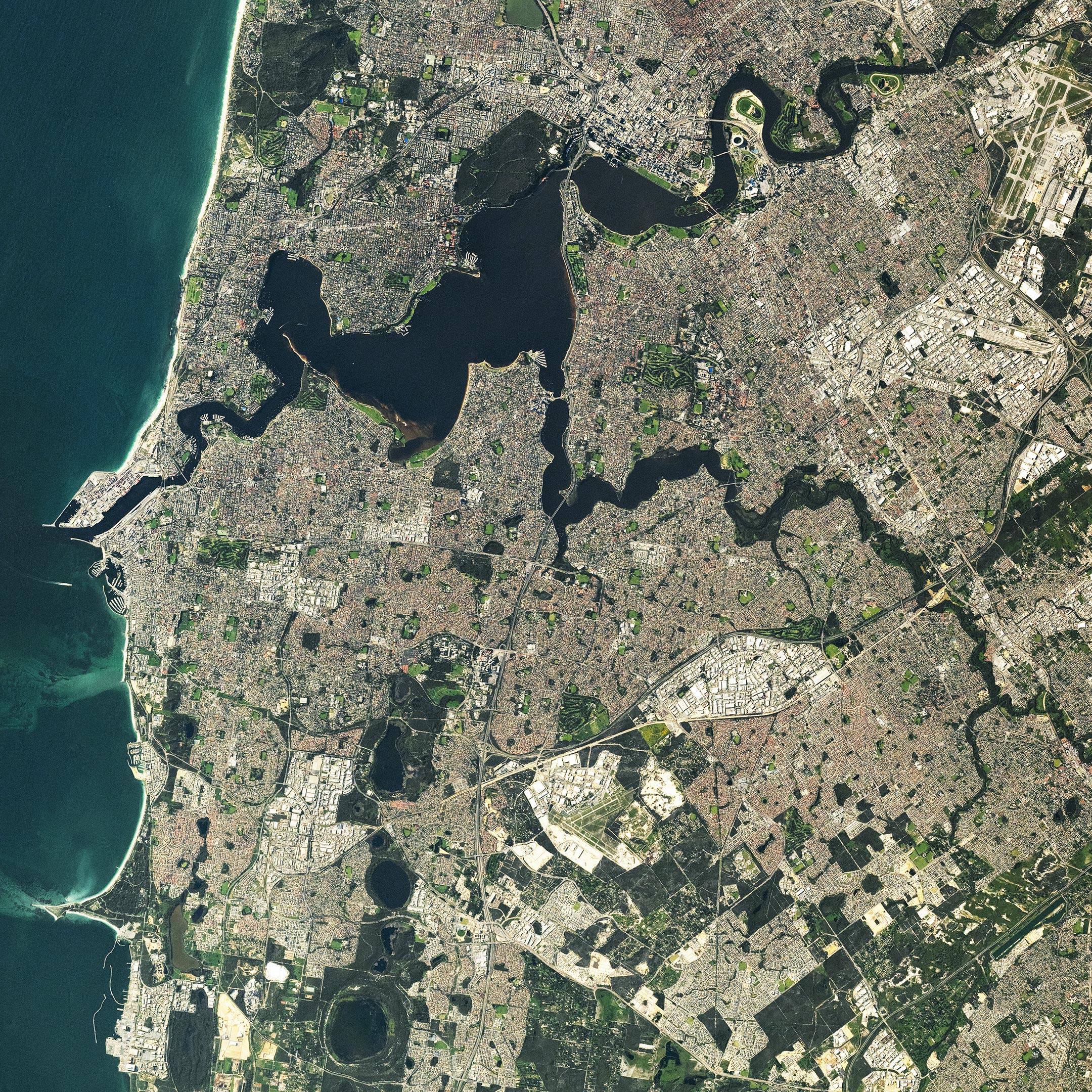
Photograph of Perth From Space
An astronaut aboard the International Space Station (ISS) captured this stunning photograph of Perth, the capital city of Western Australia. Situated along Australia’s Indian Ocean coastline, Perth is divided by the Swan and Canning rivers. The image highlights the metropolitan area spread across the river basin, with extensions reaching along the riverbanks toward Fremantle Harbour. At the bottom of the image, the angular geometry of agricultural fields provides a stark contrast to the densely built urban landscape.
Contrasting Urban and Agricultural Landscapes
Perth’s terrain is a vibrant mix of residential neighborhoods, distinguished by their pinkish-red rooftops, and commercial or industrial zones, marked by light-colored roofs. As Australia’s fourth-largest metropolitan area by population, Perth is the only city on the western coastline with more than one million residents. Perth Airport ranks among the busiest in the nation, serving as a vital hub for both passengers and air freight. The city’s central business district and the Western Australian Parliament House are strategically located near the intersection of the Swan and Canning rivers.
Fremantle Harbour and Historical Significance
Fremantle Harbour is located at the mouth of the Swan River. The port handles a variety of goods entering and exiting the country, including grains, petroleum, and agricultural fertilizers. The surrounding municipality of Fremantle is historically significant as one of the oldest European settlements within Perth. It is known for its rich architectural history, with several of its original limestone-walled buildings still standing.
Natural Ecosystems in the Urban Environment
Within the urban landscape, the dark green color of wetland and brushland ecosystems stands out. Bold Park and Kings Park are located between the northern banks of the Swan River and the Indian Ocean. These native landscapes provide habitat for land animals and migratory birds, including the splendid fairy-wren and the black-striped snake. In southern Perth, Beeliar Park is comprised of wetlands and seasonal freshwater lakes that typically dry up during the summer months. Thomsons Lake, located at the southern extent of Beeliar Park, was designated a Ramsar wetland area due to its importance as a bird refuge and mating ground for endangered species such as the Australasian bittern.
Astronaut photograph ISS071-E-615058 was acquired on September 9, 2024, with a Nikon Z9 digital camera using a focal length of 400 millimeters. It is provided by the ISS Crew Earth Observations Facility and the Earth Science and Remote Sensing Unit, Johnson Space Center. The image was taken by a member of the Expedition 71 crew. The image has been cropped and enhanced to improve contrast, and lens artifacts have been removed. The International Space Station Program supports the laboratory as part of the ISS National Lab to help astronauts take pictures of Earth that will be of the greatest value to scientists and the public, and to make those images freely available on the Internet.
Never miss a breakthrough: Join the SciTechDaily newsletter.
Follow us on Google and Google News.
1 Comment
Very interesting and educational phenomena of the nature. Nice to know these documentary THANK you .