Close Menu
    Facebook X (Twitter) Instagram
    SciTechDaily
    • Biology
    • Chemistry
    • Earth
    • Health
    • Physics
    • Science
    • Space
    • Technology
    Facebook X (Twitter) Pinterest YouTube RSS
    SciTechDaily
    Home»Earth»Radar Revealed: The North Channel’s Colorful Secrets From Space
    Earth

    Radar Revealed: The North Channel’s Colorful Secrets From Space

    By European Space Agency (ESA)November 23, 2023No Comments3 Mins Read
    Facebook Twitter Pinterest Telegram LinkedIn WhatsApp Email Reddit
    Share
    Facebook Twitter LinkedIn Pinterest Telegram Email Reddit
    North Channel From Space
    The North Channel, a strait between Northern Ireland and Scotland, is beautifully captured in a false-color radar image from the Copernicus Sentinel-1 mission. This detailed image, made using dual-polarization radar technology, showcases diverse land and water features. It highlights the rugged Scottish coastline, the large city of Glasgow, numerous lakes including Lough Neagh, and the prominent Isle of Man. Credit: Contains modified Copernicus Sentinel data (2023), processed by ESA, CC BY-SA 3.0 IGO

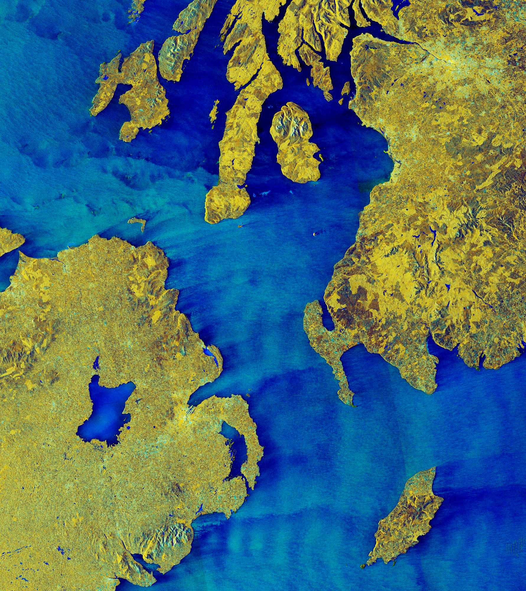
    The Copernicus Sentinel-1 mission’s radar image of the North Channel vividly displays land and water features, including Glasgow, Lough Neagh, and the Isle of Man.

    The North Channel, between Northern Ireland and Scotland, is featured in this false-color radar image from the Copernicus Sentinel-1 mission.

    The North Channel is a strait linking the Irish Sea and the North Atlantic Ocean and spans a width of about 22 km (14 miles) at its narrowest point.

    Imaging Techniques and Land Features

    This dual-polarization image combines information from horizontal and vertical radar pulses. This processing technique helps to distinguish different types of surface, thereby providing detailed information.

    Here, most of the land is shown in vibrant shades of green and yellow, with built-up areas appearing much lighter than the surroundings. Water is clearly reflected in various shades of blue.

    Coastal Highlights and Urban Centers

    The rugged Scottish coastline on the right is indented by several inlets, including the large Firth of Clyde with the tiny Ailsa Craig islet at its mouth and the large island of Arran in the middle.

    Visible as a brighter area in the top right corner of the image, Glasgow is the largest city in Scotland. It lies on the River Clyde, about 30 km (19 miles) from the mouth of the river on the west Atlantic coast. The Highlands are partly pictured at the top of the image.

    Lakes and Urban Landscapes

    Numerous lakes speckle the image in electric blue, both in Scotland and in Northern Ireland. With an area of almost 400 sq km (150 sq miles), the largest lake in the image is Lough Neagh, some 30 km (19 miles) west of Northern Ireland’s capital Belfast. The city lies on the River Lagan, at its entrance to Belfast Lough, the largest inlet visible here on the Irish coastline.

    Islands and Oceanography

    In the bottom right corner, the Isle of Man stands out in the blue waters of the Irish Sea.

    Distinct wave patterns can be seen easily since the radar signal is highly sensitive to changes in the roughness of the water. In this image, calm waters appear darker, while rough seas appear brighter.

    Since measurements of waves from buoys and ships are limited, radar images from satellites can be used to help forecast ocean waves. Being able to predict their movement can benefit mariners, port and rig builders, and coastal farmers.

    Never miss a breakthrough: Join the SciTechDaily newsletter.
    Follow us on Google and Google News.

    European Space Agency Geography
    Share. Facebook Twitter Pinterest LinkedIn Email Reddit

    Related Articles

    Breathtaking View of Andros, Bahamas From Space [Video]

    Stunning Views of Houston Texas From Copernicus Sentinel-1 Satellite

    Earth From Space: Bolivian Highland Heart [Video]

    Flevoland, Netherlands From Space: One of the Largest Land Reclamation Projects in the World

    Earth From Space: Lake George, Uganda – A Center for Biological Diversity [Video]

    Deforestation in Bolivia Spied From Space Satellite

    Earth From Space: Japanese Archipelago [Video]

    Earth From Space: Faroe Islands [Video]

    Earth From Space: Tromsø, Norway [Video]

    Leave A Reply Cancel Reply

    • Facebook
    • Twitter
    • Pinterest
    • YouTube

    Don't Miss a Discovery

    Subscribe for the Latest in Science & Tech!

    Trending News

    289-Million-Year-Old Reptile Mummy Reveals Origin of Human Breathing System

    New Brain Discovery Challenges Long-Held Theory of Teenage Brain Development

    Scientists Discover Plants “Scream” – We Just Couldn’t Hear Them Until Now

    Scientists Discover a Surprising Reason Intermittent Fasting Extends Life

    This Simple Fruit Wash Could Make Produce Safer and Last Days Longer

    Scientists Say Adding This Unusual Seafood to Your Diet Could Reverse Signs of Aging

    Scientists Say a Hidden Structure May Exist Inside Earth’s Core

    Doctors Surprised by the Power of a Simple Drug Against Colon Cancer

    Follow SciTechDaily
    • Facebook
    • Twitter
    • YouTube
    • Pinterest
    • Newsletter
    • RSS
    SciTech News
    • Biology News
    • Chemistry News
    • Earth News
    • Health News
    • Physics News
    • Science News
    • Space News
    • Technology News
    Recent Posts
    • Scientists Propose Radical New Way To Detect Alien Life – Without Traditional Biosignatures
    • Scientists Just Discovered Light Can Actually Slow Plant Growth
    • Scientists Finally Solved One of Water’s Biggest Mysteries
    • 7,000-Year-Old DNA Rewrites the Story of the “Neolithic Revolution”
    • Missing Medieval Relic of Legendary English King Found After Being Missing for 40 Years
    Copyright © 1998 - 2026 SciTechDaily. All Rights Reserved.
    • Science News
    • About
    • Contact
    • Editorial Board
    • Privacy Policy
    • Terms of Use

    Type above and press Enter to search. Press Esc to cancel.