Analysis of the impact craters on Ryugu using the spacecraft Hayabusa 2’s remote sensing image data has illuminated the geological history of the Near-Earth asteroid.
A research group led by Assistant Professor Naoyuki Hirata of the Department of Planetology at Kobe University’s Graduate School of Science revealed 77 craters on Ryugu. Through analyzing the location patterns and characteristics of the craters, they determined that the asteroid’s eastern and western hemispheres were formed at different periods of time.
It is hoped that the collected data can be used as a basis for future asteroid research and analysis.
These results were first published in the American Scientific Journal ‘Icarus’ on November 5, 2019.
Introduction
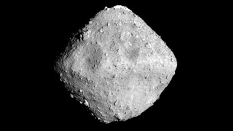
The Japan Space Agency (JAXA)’s Hayabusa 2 has been used to carry out various missions to increase our understanding of the spinning top-shaped, Near-Earth asteroid Ryugu. Since arriving in June 2018, the unmanned spacecraft has taken samples and a great number of images of the asteroid. It is hoped that these can reveal more about Ryugu’s formation and history.
This research group focused on using the image data to determine the number and location of impact craters on the asteroid. Impact craters are formed when a smaller asteroid or a comet hits the surface of the asteroid. Analyzing the spatial distribution and the number of impact craters can reveal the frequency of collisions and aid researchers in determining the age of different surface areas.
Research Methodology
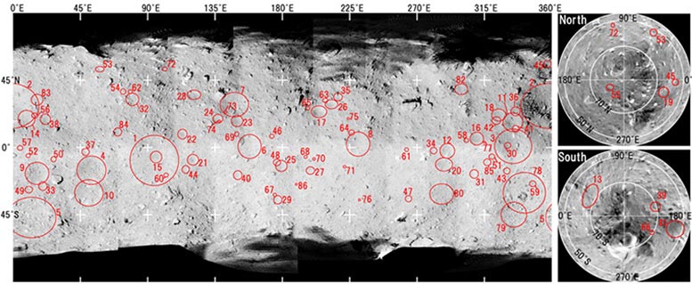
First of all, the image data from Hayabusa 2 was analyzed. Hayabusa 2 has many different types of camera including Optical Navigation Cameras (ONC). The ONC team has been able to take around 5000 images of Ryugu, which have revealed many surface features- including impact craters. For this study, image data obtained from the ‘ONC-T’ camera between July 2018 and February 2019 was utilized. The research group had to determine which of these images showed craters. 340 images were used for crater counting, with stereopair images making it easier to identify the craters. A global image mosaic map was constructed from the ONC images and rendered onto the computer model of Ryugu’s shape. Small Body Mapping Tool software was then used to measure the size, latitude, and longitude of the craters. A LiDAR (Light Detection and Ranging pulsed laser) was also utilized to determine the overall size of Ryugu.
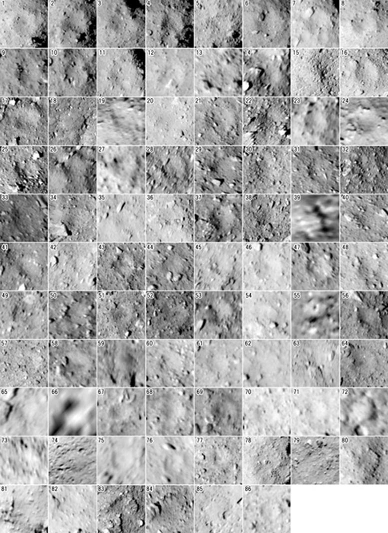
The depressions identified on Ryugu were divided into four categories- depending on how evident their circular appearance was. Category I to III depressions were classified as distinct craters. Category IV depressions only had quasi-circular features, therefore it was hard to determine whether they were craters or not. Many craters were filled with boulders or lacked a distinct shape. Depressions that were too vague to determine were left out of the results.
Research Results:
The research team were able to identify all impact craters over 10 to 20m in diameter on Ryugu’s entire surface- a total of 77 craters. Furthermore, a pattern was discovered in their distribution. The section of the eastern hemisphere near the meridian was found to have the most craters. This is the area near the large crater named Cendrillon — which is one of Ryugu’s biggest. In contrast, there are hardly any craters in the western hemisphere- suggesting that this part of the asteroid was formed later. The analysis also revealed that there are more craters at lower latitudes than at higher latitudes on Ryugu. In other words, there are very few craters in Ryugu’s polar regions.
The equatorial ridge in the eastern hemisphere was determined to be a fossil structure. When asteroids like Ryugu rotate at high speeds, this can alter their shape. It is thought that this ridge formed in the distant past during a period when it only took Ryugu 3 hours to rotate. As the eastern hemisphere and western hemisphere were formed at different periods of the asteroid’s history- this suggests that there have been at least two instances where Ryugu’s rotational speed has increased.
Reference: “The spatial distribution of impact craters on Ryugu” by Naoyuki Hirata, Tomokatsu Morota, Yuichiro Cho, Masanori Kanamaru, Sei-ichiro Watanabe, Seiji Sugita, Naru Hirata, Yukio Yamamoto, Rina Noguchi, Yuri Shimaki, Eri Tatsumi, Kazuo Yoshioka, Hirotaka Sawada, Yasuhiro Yokota, Naoya Sakatani, Masahiko Hayakawa, Moe Matsuoka, Rie Honda, Shingo Kameda, Manabu Yamada, Toru Kouyama, Hidehiko Suzuki, Chikatoshi Honda, Kazunori Ogawa, Yuichi Tsuda, Makoto Yoshikawa, Takanao Saiki, Satoshi Tanaka, Fuyuto Terui, Satoru Nakazawa, Shota Kikuchi, Tomohiro Yamaguchi, Naoko Ogawa, Go Ono, Yuya Mimasu, Kent Yoshikawa, Tadateru Takahashi, Yuto Takei, Atsushi Fujii, Hiroshi Takeuchi, Tatsuaki Okada, Kei Shirai and Yu-ichi Iijima, 5 November 2019, Icarus.
DOI: 10.1016/j.icarus.2019.113527
Never miss a breakthrough: Join the SciTechDaily newsletter.
Follow us on Google and Google News.