
On Libya’s Messak Settafet plateau, Cretaceous sandstone tells a dual story: modern oil field operations and remnants of Stone Age quarries and hunting grounds.
Libya’s Messak Settafet plateau, as seen from space, showcases its geological and archaeological significance. Featuring a steep escarpment and evidence of ancient water flows, it also holds the El-Feel oil field and sites of prehistoric tool-making and rock art, reflecting millennia of human utilization.
Messak Settafet Plateau
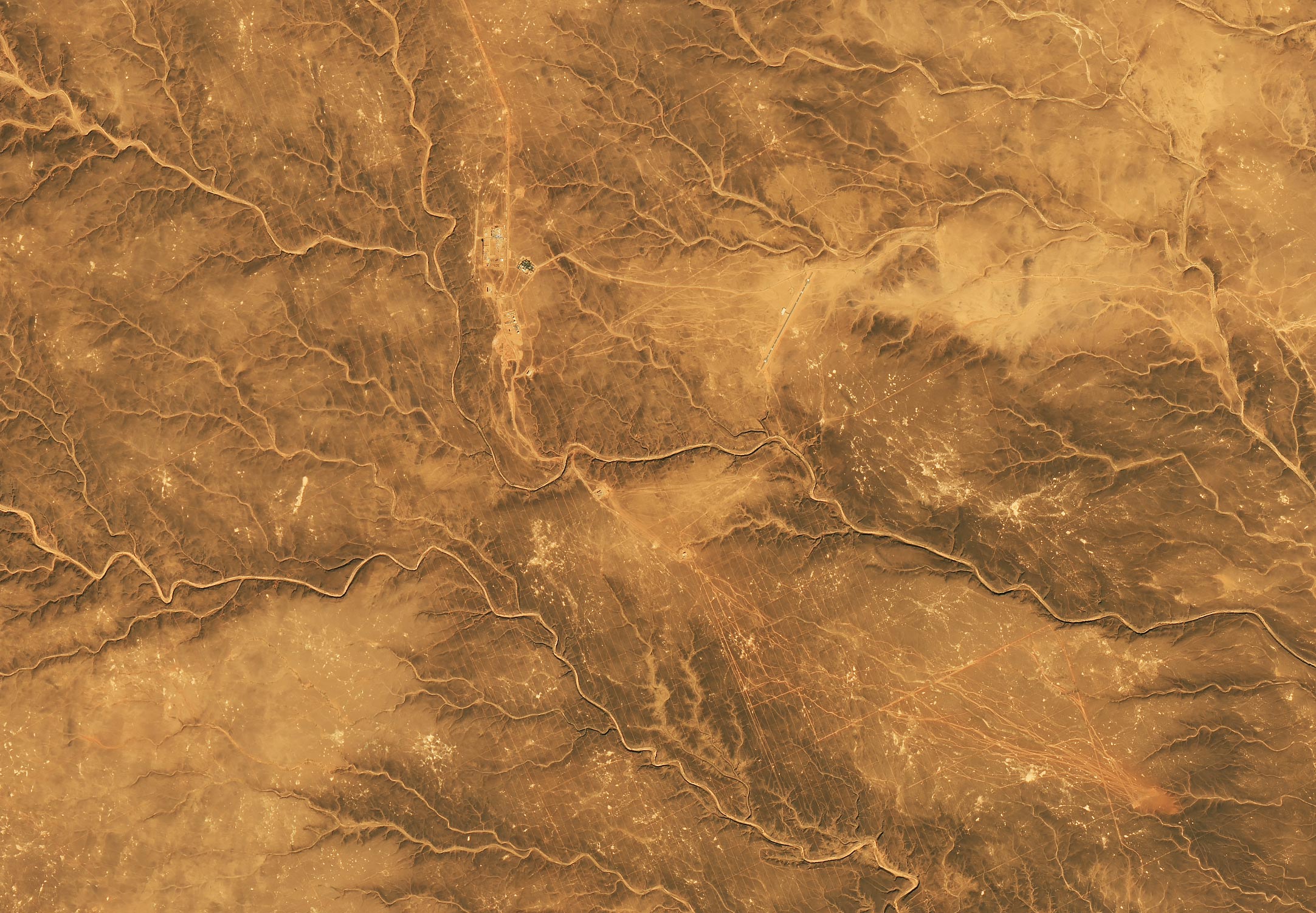
Rising dramatically above the desert in southwestern Libya, the Messak Settafet plateau stands like the wall of a colossal fortress. Its rugged, erosion-resistant sandstone forms a natural boundary, separating the Ubari Sand Sea to the north from the Marzūq Sand Sea to the south.
Captured by the Operational Land Imager-2 (OLI-2) on Landsat 9 on November 17, 2024, this plateau is a striking expanse of Cretaceous rock. Its northern edge features a steep escarpment, soaring up to 300 meters (1,000 feet) high in places. A thin, dark shadow traces the cliff’s edge in the satellite image, while scattered debris from rockfalls is visible on the northern side. Interestingly, an optical phenomenon known as relief inversion can cause high-elevation areas to appear sunken and low-elevation areas to look raised, depending on how shadows fall across the landscape.
Arid Climate and Historical Water Flow
Although the plateau now receives less than 10 millimeters (0.4 inches) of rain annually, clues in the landscape make clear it was once much wetter. Deeply incised dried stream valleys, or wadis, crisscross the plateau, indicating significant past water flow. The small, bright features scattered across the plateau are sand and silt deposits left where water once pooled.
A dusty road winds its way up the escarpment’s edge near the center of the image and runs along the plateau’s top. The second image above shows where that road leads—to the El-Feel oil field in the middle of the plateau. Secondary roads lead to rows of oil wells, power lines, pipelines, office buildings, and a runway. The faint grid-like pattern of lines around the oil field is a remnant of seismic surveys used to determine the best places to drill. Oil was discovered here in 1997, and the oil field began producing in 2004.

Stone Age Industries on Messak Settafet
Oil companies are not the first to exploit Messak Settafet’s resources. Archaeologists have unearthed evidence that hominins—a taxonomic group that encompasses Homo sapiens and other extinct species such as Homo neanderthalensis and Homo erectus—have mined the plateau for quartzite to make tools since the Stone Age.
Signs of ancient toolmaking cover much of the plateau’s surface. According to one archaeological survey, people discarded so many stone tools and rock fragments on the plateau over hundreds of thousands of years that roughly 75 artifacts per square meter now carpet the surface. That makes this one of the earliest known examples of hominins modifying an entire landscape, according to the University of Cambridge archaeologists who conducted the survey.
Other signs of ancient activity include the bright spots that dot the image. These areas were likely quarrying pits where people dug up rocks and crafted them into tools, the archaeologists reported. Since these depressions would have retained extra water after rains, they left these sandy and silty deposits. They also likely attracted game. Based on the density of notched “tethering” stone artifacts found within the deposits, they were likely used as hunting and trapping sites.
Ancient Rock Art and Engravings
Archaeologists have also documented large amounts of petroglyphs, cave paintings, and other rock art on and around the plateau, though such works are too small to be seen in these images. For instance, Wadi Mathendous, a prehistoric archaeological site located in the southern part of the plateau, contains engravings of rhinoceroses, crocodiles, hippopotamuses, fighting cats, giraffes, long-horned buffaloes, and elephants. The art is thought to be about 8,000 years old.
NASA Earth Observatory images by Michala Garrison, using Landsat data from the U.S. Geological Survey.
Never miss a breakthrough: Join the SciTechDaily newsletter.
Follow us on Google and Google News.