Mapping beneath Thwaites Glacier has revealed geological features affecting its retreat, offering vital insights to refine sea-level rise predictions.
For the first time, a team including an expert from Swansea has charted the ground beneath Antarctica’s most at-risk glacier, providing vital insights into its susceptibility to climate change.
The team’s study of the sub-glacial geology of West Antarctica’s Thwaites Glacier revealed a scarcity of sedimentary rock — an unexpected outcome that may influence the glacier’s movement into the ocean in the coming decades.
The glacier, which is the size of Great Britain or the US state of Florida, is one of the fastest-changing ice-ocean systems in Antarctica.
The research was led by the British Antarctic Survey (BAS) and involved Professor Bernd Kulessa, a glaciologist in Swansea University’s geography department. The findings have resulted in a new map of the geology of the region, produced by the BAS researchers and published in the journal Science Advances.
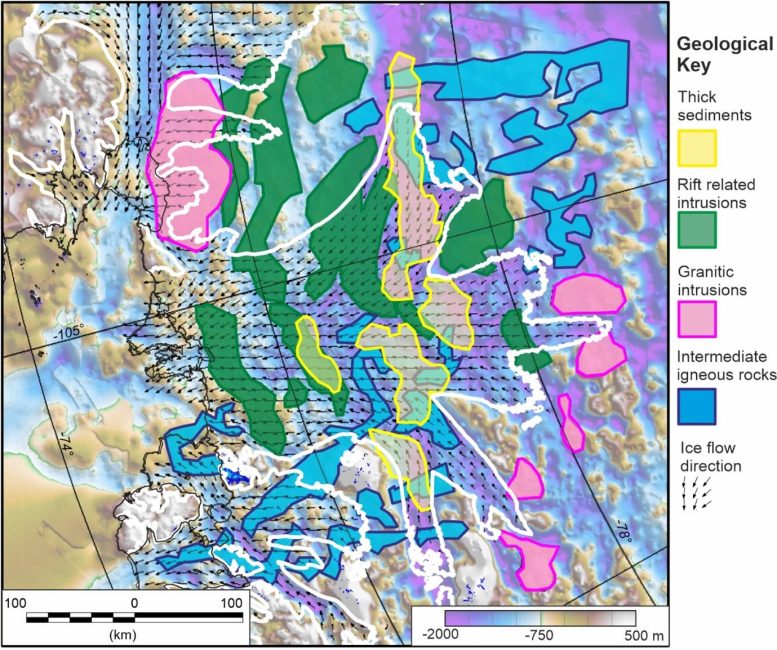
Dr. Tom Jordan, a geophysicist with the British Antarctic Survey, who led the study, said: “Sediments allow faster flow, like sliding on mud. Now we have a map of where the slippery sediments are, we can better predict how the glacier will behave in the future as it retreats.”
The Thwaites glacier’s grounding zone — the point where it meets the seafloor — has retreated 14 km since the late 1990s. Much of the ice sheet is below sea level and susceptible to rapid, irreversible ice loss that could raise the global sea level by over half a meter within centuries.
Mapping the Hidden Ground Beneath the Glacier
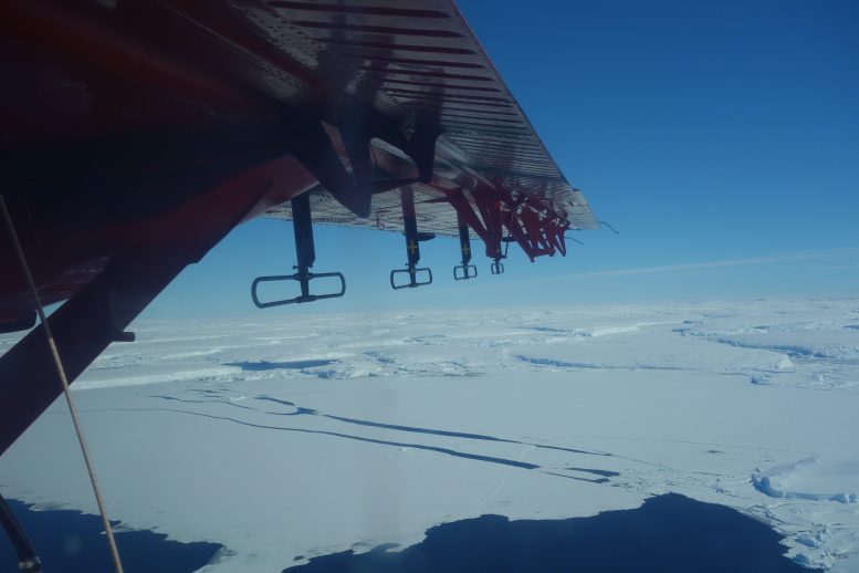
The new analysis is based on airborne surveys using aircraft equipped with radar that can see through the ice to the rocks below, as well as sensors that can map minute variations in gravity and magnetism thousands of meters below the ground and seabed on which the glacier rests.
The researchers then use these multiple data sources to compile a 3D picture of features, including the type and extent of different rocks.
It’s not yet clear how this new knowledge of the subglacial geology will affect estimates of ice flow and loss from Thwaites and other glaciers. The study does show that the geological landscape has a direct control on the basal shear stress, which influences how fast ice can flow into the ocean. Members of the research team will now carry out more detailed studies of these processes. Modelers may also be able to use the new data to make more reliable projections of future ice loss.
Predicting the Future of Ice Flow and Climate Impact
Professor Bernd Kulessa of Swansea University geography department said: “The ongoing rapid retreat of the Thwaites Glacier is arguably one of the greatest uncertainties in future sea level rise predictions. By combining a series of airborne geophysical datasets and analyzing them using state of the science concepts, our study reveals the geology beneath the ice for the first time. This is important because the glacier ice can slip more easily over some types of rock than others, and geothermal heating will help the ice to slip even faster in some areas. Our study, therefore, provides an exciting and novel basis for better predictions of future Thwaites Glacier ice flow and sea level rise.”
Professor Tom Jordan added: “We hope that by showing the detailed geology, and how it correlates with the basal friction, future models of glacial retreat will have lower uncertainty, as the controls of the basal processes will be better understood.
No single scientific study could ever match the scale and challenge of climate change. But it is the incremental building of all the individual scientific studies like this that allows us to understand and tackle that challenge.”
Reference: “Geological sketch map and implications for ice flow of Thwaites Glacier, West Antarctica, from integrated aerogeophysical observations” by Tom A. Jordan, Sarah Thompson, Bernd Kulessa and Fausto Ferraccioli, 31 May 2023, Science Advances.
DOI: 10.1126/sciadv.adf2639
Professor Kulessa is a UK investigator in the project GHOST (Geophysical Habitats of Subglacial Thwaites), one of eight major scientific projects jointly funded by the US National Science Foundation and the UK Natural Environment Research Council as part of the International Thwaites Glacier Collaboration
Never miss a breakthrough: Join the SciTechDaily newsletter.
Follow us on Google and Google News.
3 Comments
“The team’s study of the sub-glacial geology of West Antarctica’s Thwaites Glacier revealed a scarcity of sedimentary rock …”
The rest of the story is, it is mostly igneous rocks. That probably accounts for the locally high rate of melting compared to East Antarctica. A few years ago, something like 92 under-ice volcanoes, which were previously unknown, were identified in the area.
“The ongoing rapid retreat of the Thwaites Glacier is arguably one of the greatest uncertainties in future sea level rise predictions… This is important because the glacier ice can slip more easily over some types of rock than others, and geothermal heating will help the ice to slip even faster in some areas.”
“Retreat” with respect to glaciers doesn’t mean the same thing as the retreat of an army. The glacier continues its forward motion from the source area(s), while melting at the leading edge or terminus. The rate of ‘retreat’ is the net difference between forward movement and ablation (melting, sublimation, and calving). All glaciers are known to surge, or have speed ups in the forward rate of movement, the reasons for which are not well known, but probably is related to basal water abundance. In the absence of basal melting, those ‘slippery’ sediments could be frozen to the overlying ice sheet and provide greater resistance to forward motion than smoothed bedrock with meltwater between it and the ice.
This field work is interesting and provides us with additional information. However, the situation is much more complex than is suggested by the university press release.
Where should we send the money?
bonjour, les premieres etudes qui annoncais sa ruptur prochaine 3 a 5 ans est donc écarté ?