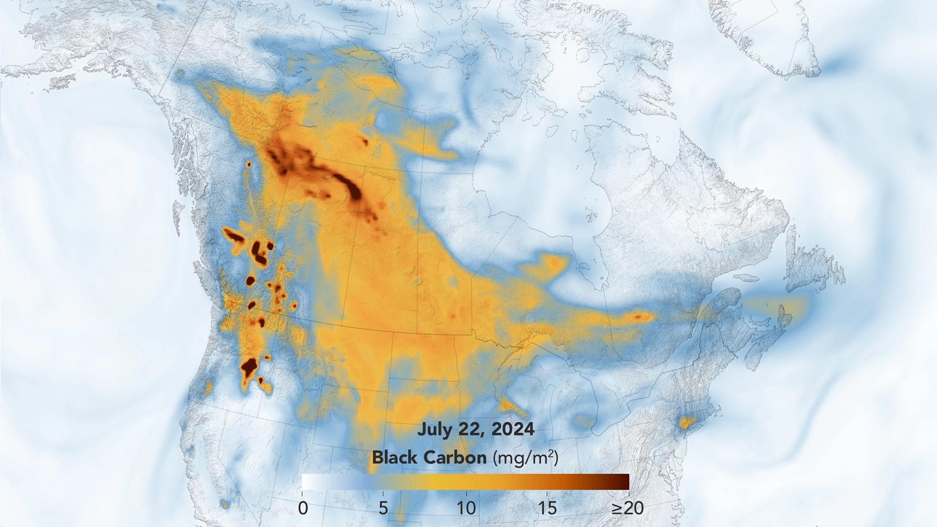
Canada’s July 2024 wildfires, driven by heat and thunderstorms, caused significant smoke spread across North America. NASA’s GEOS-FP model mapped this, showing extensive soot movement.
Hundreds of wildland fires lofted sky-dulling smoke over Canada and the United States.
In July 2024, wildfires in Canada were exacerbated by extreme heat, winds, and thunderstorms, leading to 989 active fires, primarily in British Columbia and Alberta. NASA’s GEOS-FP model tracked the spread of black carbon particles, showing extensive smoke movement across North America. High winds, record temperatures, and lightning strikes created optimal conditions for these wildfires, causing new fires and evacuations, especially in Jasper National Park. Pyrocumulonimbus clouds further spread smoke high into the atmosphere, worsening air quality in multiple U.S. states.
Canada Wildfires and Smoke Impact
In July 2024, wildland fires erupted in Canada, sending smoke billowing across North America. A stretch of extreme heat, coupled with windy conditions and thunderstorms, helped spur the ignition and expansion of fires in several Canadian provinces. As of July 24, 989 fires actively burned in Canada, with over half of those occurring in British Columbia or Alberta, according to the Canadian Interagency Forest Fire Centre.
The animation below highlights the concentration and movement of wildfire smoke from July 17–24, 2024. It shows black carbon particles—commonly called soot—from Canadian fires sweeping broadly across North American skies during that period. Black carbon signatures from fires in Oregon and Washington are also prominent.
The black carbon data come from NASA’s GEOS forward processing (GEOS-FP) model, which assimilates data from satellites, aircraft, and ground-based observing systems. In addition to making use of satellite observations of aerosols and fires, GEOS-FP also incorporates meteorological data like air temperature, moisture, and winds to project the plume’s behavior.
Intensifying Wildfires in British Columbia and Alberta
Wildfire activity in British Columbia and Alberta intensified throughout the period shown in the animation, as unsettled weather entered the region. High winds and thunderstorms, on top of record-high temperatures in some places, created prime conditions for wildfires. The B.C. Wildfire Service reported 20,000 lightning strikes on July 21 and 38,000 on July 22, with most of those strikes occurring in the northeast part of the province and the rest in the south-central portion.
The storms resulted in scores of new fires and multiple evacuations from towns and public lands. Smoke from the hundreds of active fires drifted across the country and south into the central United States. Smoky skies and poor air quality were reported in multiple states, including North Dakota, Kansas, Colorado, and Wisconsin.
July 23, 2024
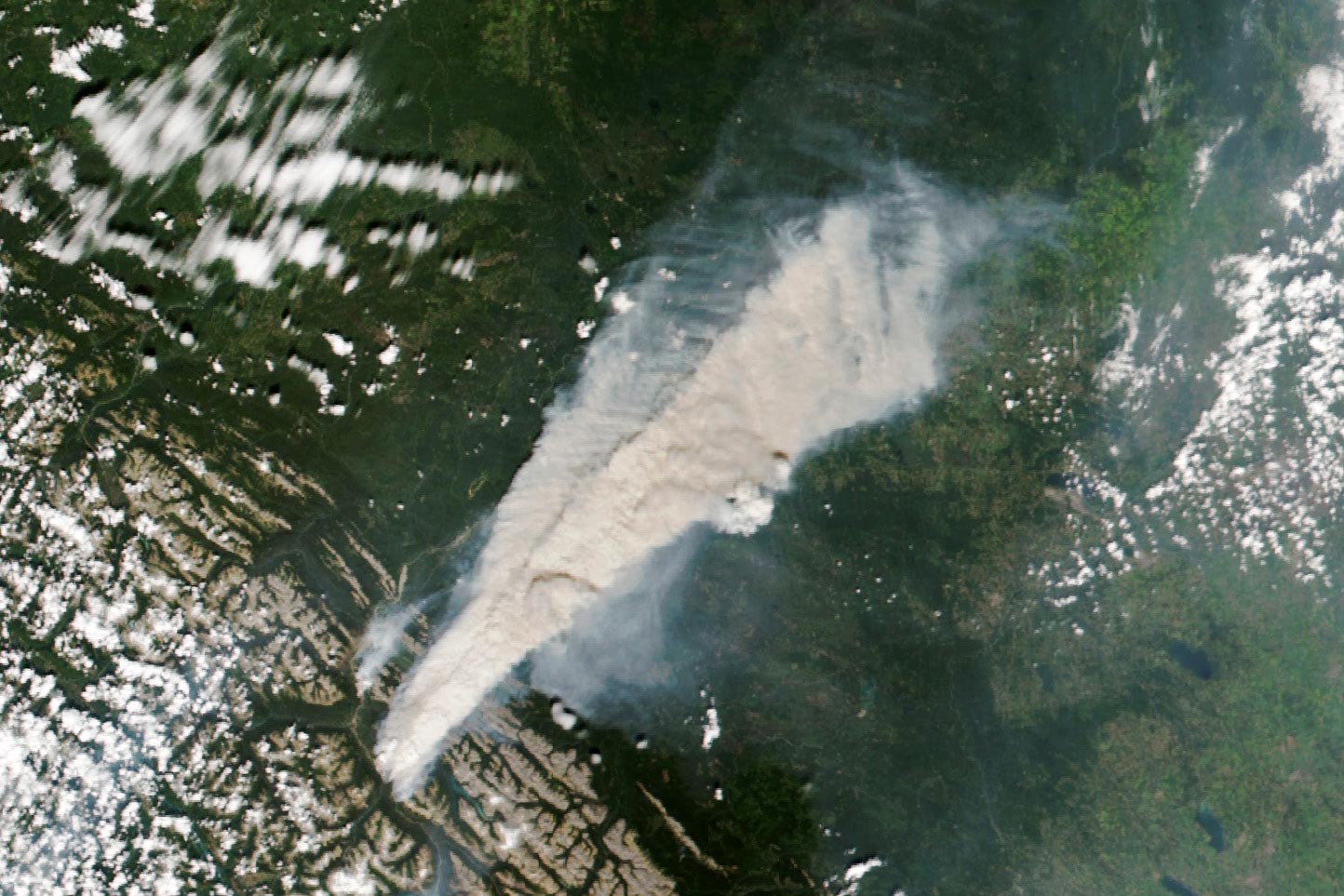
Fires in Jasper National Park
Multiple fires in Jasper National Park in Alberta caused up to 25,000 visitors and residents to leave the area on July 23, according to news reports. The image above, acquired on that day with the VIIRS (Visible Infrared Imaging Radiometer Suite) on the NOAA-20 satellite, shows a dense plume of smoke emanating from these fires.
Pyrocumulonimbus Clouds
The remnant of a pyrocumulonimbus, or pyroCb, cloud is visible along the southern edge of the plume. These towering smoke-infused storm clouds loft smoke high in the atmosphere, where fast-moving upper-level winds can spread it widely. A brief pyroCb occurred about 70 minutes before this image was acquired, said Michael Fromm, a meteorologist at the U.S. Naval Research Laboratory. Scientists detected several other pyroCbs in British Columbia blazes during this outbreak of fire.
NASA Earth Observatory images by Wanmei Liang, using GEOS-5 data from the Global Modeling and Assimilation Office at NASA GSFC and VIIRS data from NASA EOSDIS LANCE, GIBS/Worldview, and the Joint Polar Satellite System (JPSS).


The NASA smoke animation shows mg/m^2 (milligrams per square meter) of “black Carbon.” An area (m^2), has no volume and therefore can have no weight. That should be given as total particulate carbon weight for a square meter column of air either to the top of the atmosphere, or to the maximum height of the smoke. Sloppy science, which I’ve come to expect from NASA and climatologists!