Ingenuity’s 10th and most complex flight will image Mars’ Raised Ridges to aid Perseverance’s mission, marking a milestone as it exceeds 1 mile flown and 100 sols of operation.
Ingenuity has come a long way from its original airfield, “Wright Brothers Field,” which is 0.64 miles (1.04 kilometers) to the northeast of our current location. We got here during Flight 9, an endeavor that had our helicopter breaking several of our own records as we relocated to the far side of the “Séítah” geologic unit. Covering 2,051 feet (625 meters), Flight 9 was executed so that Ingenuity could provide valuable imagery and information for the Perseverance science team.

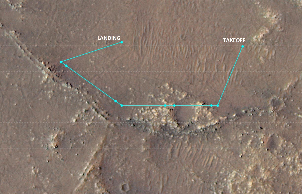
Flight 10 will allow us to reap the benefits of our previous flight. Scheduled for no earlier than this Saturday (July 24), Flight 10 will target an area called the “Raised Ridges” (RR), named for the geographic features that start approximately 164 feet (50 meters) south-by-southwest of our current location. We will be imaging Raised Ridges because it’s an area that Perseverance scientists find intriguing and are considering visiting sometime in the future.
A Complex Mission with Stereo Vision
From navigation and performance perspectives, Flight 10 will be our most complex flight to date, with 10 distinct waypoints and a nominal altitude of 40 feet (12 meters). It begins with Ingenuity taking off from its sixth airfield and climbing to the new record height. It will then head south-by-southwest about 165 feet (50 meters), where upon hitting our second waypoint, take our first Return to Earth (RTE) camera image of the Raised Ridges, looking south. Next, we’ll translate sideways to waypoint 3 and take our next RTE image – again looking south at Raised Ridges.
Imagery experts at JPL hope to combine the overlapping data from these two images to generate one stereo image. Flying farther to the west, we’ll try for another stereo pair of images (waypoints 4 and 5), then head northwest for two more sets of stereo pairs at waypoints 6 and 7 as well as 8 and 9. Then, Ingenuity will turn northeast, landing at its seventh airfield – about 310 feet (95 meters) west of airfield 6. Total time in the air is expected to be about 165 seconds.
A Milestone Moment for Ingenuity
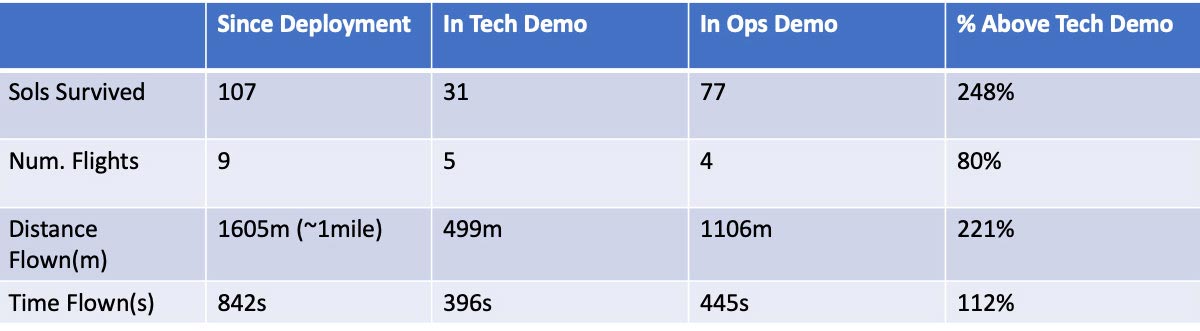
Ingenuity has survived 107 sols (Martian days) since deployment from Perseverance, 76 sols beyond the original technology demonstration mission it was designed for. It has also successfully executed two separate flight-software updates, improving the aircraft’s ability to execute flights and capture color imagery (collecting 43 13 MP images to date). It’s flown a total distance of 0.997 miles (1.605 kilometers), with total time aloft of 842 seconds (14 minutes, 2 seconds), in nine flights. Should we be successful, we’ll cross the 1-mile total distance metric with Flight 10.
Performance Summary
- Two separate flight-software upgrades, which have improved the aircraft’s operational ability to execute flights and capture 13MP color images.
- 43 13MP Color Images
- 809 B&W Navigation Images
Written by Teddy Tzanetos, Operations Lead for Ingenuity Mars Helicopter – Ops. Demo. at NASA’s Jet Propulsion Laboratory
Never miss a breakthrough: Join the SciTechDaily newsletter.
Follow us on Google and Google News.
1 Comment
I see a yellow dashed line depicting the flight route. I don’t see any “hash marks.”