
According to a study conducted by the University of Bonn, droughts caused the land in Germany to rise by six millimeters between 2012 and 2020.
South Africa is gradually rising by as much as two millimeters per year depending on the region. Until now, scientists believed this land uplift was caused by mantle flow within the Earth’s crust.
However, a new study from the University of Bonn suggests a different explanation: droughts and the resulting loss of water are the primary drivers of this vertical movement. The findings have been published in the Journal of Geophysical Research: Solid Earth.
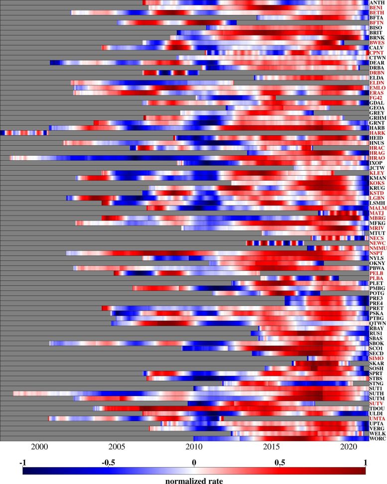
Researchers have known for years that South Africa is rising, thanks to a network of permanent GPS stations across the country. These stations allow scientists to measure both horizontal position and elevation with millimeter-level precision using satellite data.
“This data showed an average rise of six millimeters between 2012 and 2020,” says Dr. Makan Karegar of the Institute of Geodesy and Geoinformation at the University of Bonn, who is also part of the university’s transdisciplinary research area “Sustainable Futures.”
Until now, many researchers attributed this rise to a geodynamic process. They theorized that a plume—a massive, tube-like structure carrying hot material from deep within the Earth—exists beneath the region. The upward pressure from this plume could cause the Earth’s crust to bulge, explaining the observed uplift.
“However, we have now tested another hypothesis,” Karegar explains. “We believe that the loss of groundwater and surface water due to droughts may also be responsible for the land rising.”
Uplift during droughts
Working together with Christian Mielke, Dr. Helena Gerdener, and Prof. Dr. Jürgen Kusche from the Institute of Geodesy and Geoinformation, Karegar investigated this theory in the recently published paper.
During their research, the team examined, among other things, precipitation patterns across the different regions of South Africa and stumbled on some clear parallels in the data: Areas that had suffered severe droughts experienced a particularly pronounced land uplift.
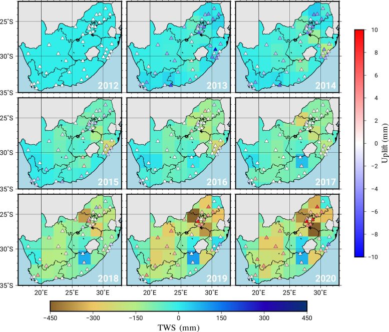
The geodesists also compared these results with data from the GRACE satellite mission. The measurement equipment in the GRACE satellites regularly measured any change in gravitational forces in the regions they had just flown over from orbit.
“These results can be used to calculate, among other things, the change in the total mass of the water storage including sum of surface water, soil moisture and ground water,” explains Christian Mielke. “However, these measurements only have a low spatial resolution of several hundred kilometers.”
Satellite data supports the drought hypothesis
It is possible to split South Africa into large planning zones based on the GRACE data and then calculate average values for each zone. Although the satellites only provide a rough picture of the water distribution, they also clearly show that the lower the mass of water in a planning zone, the higher the uplift at the GPS stations in that zone. Hydrological models also supported the hypothesis. These models can show on a computer the influence that droughts have on the water cycle at a very high resolution (in contrast to the GRACE data). “This data also showed that the land uplift could primarily be explained by drought and the associated loss of water mass,” says Mielke.
If land masses dry out, the Earth bulges in these locations, similar to a foam ball that was previously held under pressure (although in the case of the land, the pressure was exerted by water). This effect can be used to record the extent of a drought more precisely than ever before – using a method that is comparatively inexpensive and requires less effort. This is especially important because a large proportion of the water reserves are stored underneath the Earth’s surface. People have long been extracting this groundwater via wells for use as drinking water, to water their plants, and also for industrial processes.
The permanent GPS receivers can now be used to understand the extent to which these reserves have already been depleted. If needed, this information could be used to decide when it is time to start rationing this valuable resource. This problem is expected to become more serious in the future due to climate change and the resulting change in precipitation patterns. Incidentally, South Africa also acts as a good example here. The country suffered from a devastating drought between 2015 and 2019 when the City of Cape Town lived under the imminent threat of “day zero” – a day completely without water.
Reference: “GNSS Observations of the Land Uplift in South Africa: Implications for Water Mass Loss” by Christian A. Mielke, Makan A. Karegar, Helena Gerdener and Jürgen Kusche, 9 April 2025, Journal of Geophysical Research: Solid Earth.
DOI: 10.1029/2024JB030350
The study was funded by the German Research Foundation (DFG) within the framework of the Collaborative Research Centre SFB 1502/1-2022 (project number: 450058266), research group 2736 NEROGRAV (funding reference number: KU1207/29) and research group 2630 GlobalCDA (funding reference number: KU1207/26).
Never miss a breakthrough: Join the SciTechDaily newsletter.
Follow us on Google and Google News.
11 Comments
And yet, they’re simultaneously trying to convince us of rising global sea levels… again due to climate change. So which one is it? Because it can’t be both.
Of course, it can be both.
Mean sea level is rising because land-based ice (principally in Greenland and Antarctica) is melting and draining into the world’s oceans, plus the thermal expansion of all sea water. (Liquid water expanded as it warms.)
As the article states, the diminished stores of water in subsurface rocks and in surface empoundments are causing the South African landmass to rise because there is less *net* weight present than before; just as the North American continent began rising after the continental glaciers melted. Water, both frozen and liquid, is heavy. Less water is less heavy, so the earth “rebounds” upward.
You must be one of those types that believe Trump is gonna bring jobs back to America by putting everybody out of work.
If you are suffering from TDS then that’s your problem, there are others who do not suffer from that brainless disease.
Yes, it can be both. They are saying the water mantle is drying out. And ocean leaves are rising. Oceans are salt water, the water mantle, which we dig wells into to get drinking water is fresh water. So even the most basic amount of logic should get you to the conclusion that these 2 water sources are seperate
Trying to scare us into accepting a pure lie.
That’s what they’re doing.
So many ads running through this article it’s impossible to read,so I won’t. Smh
Those ads are a time better spent than the actual article.
God has authority over Heaven and earth.
fear won’t work on me
Without any science knowledge or experience we know that this “They theorized that a plume—a massive, tube-like structure carrying hot material from deep within the Earth—exists beneath the region. The upward pressure from this plume could cause the Earth’s crust to bulge, explaining the observed uplift.” Is as a result of excessive mining instead of droughts
Earth’s normal climate change continues. This does not appear to tell us much. Seems like a waste to study this especially if taxpayers are footing the bill, which I suspect. How many careers have been funded by climate change research that has done nothing for us? The land is rising the seas are rising, the weather is changing and we can’t do anything about it. So, let’s spend money on something else, something that is beneficial like for instance, feeding starving people and creating sustainable jobs.