A rapidly intensifying super typhoon sent giant atmospheric ripples skyward, revealing a hidden connection between extreme weather and near-space.
In April 2026, Super Typhoon Sinlaku swept across the North Pacific, bringing torrential rain and flooding to parts of the Mariana Islands. The storm intensified into a “violent typhoon,” the highest category used by the Japan Meteorological Agency and roughly equivalent to a Category 5 hurricane on the Saffir-Simpson scale.
What made Sinlaku especially remarkable was its timing. Meteorologists noted that only a small number of storms in the region have reached such extreme strength so early in the year.
As Sinlaku rapidly strengthened over open water, its influence extended far beyond the ocean surface. Satellites detected signs that the storm was also affecting the upper layers of Earth’s atmosphere.
Satellites Capture Giant Atmospheric Ripples
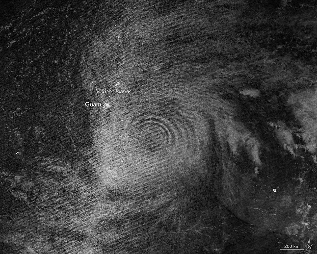
A nighttime image collected by the VIIRS (Visible Infrared Imaging Radiometer Suite) instrument aboard the NOAA-20 satellite revealed atmospheric gravity waves spreading outward from the storm. The pattern resembled ripples expanding across a pond after a stone is dropped into the water.
These waves became visible through a phenomenon known as airglow in the mesosphere. Airglow occurs when atoms and molecules that absorbed energy from sunlight during the day release that energy as faint light during the night.
Scientists have long known that tropical cyclones generate tremendous amounts of heat near their eyewalls. This heat fuels powerful thunderstorms and towering cumulonimbus clouds. Some of these towering storm clouds, often called “hot towers,” can rise beyond the troposphere, the lowest layer of the atmosphere, and send waves upward into the stratosphere and mesosphere.
Previous studies have found that gravity waves frequently appear when tropical cyclones are intensifying. Sinlaku fit that pattern. During the 24 hours before the satellite image was captured, the storm strengthened dramatically from a Category 2 system to the equivalent of a Category 5 storm.
Rare Rings Above the Storm
“We’re seeing waves propagating radially and upward, in a cone-like shape,” said Joan Alexander, senior research scientist at NorthWest Research Associates.
Alexander said she was surprised to observe nearly complete rings in the mesospheric airglow above the typhoon. Normally, winds in the upper atmosphere can weaken or disperse gravity waves before they reach such high altitudes. However, relatively weak stratospheric winds at the storm’s latitude during April 2026 may have allowed the waves to remain intact.
The viewing conditions also helped. The VIIRS day-night band can detect airglow, but it also records reflected moonlight. On April 12, the Moon was only about 25 percent illuminated. Some reflected light from clouds below was visible, but not enough to overwhelm the much fainter airglow signal.
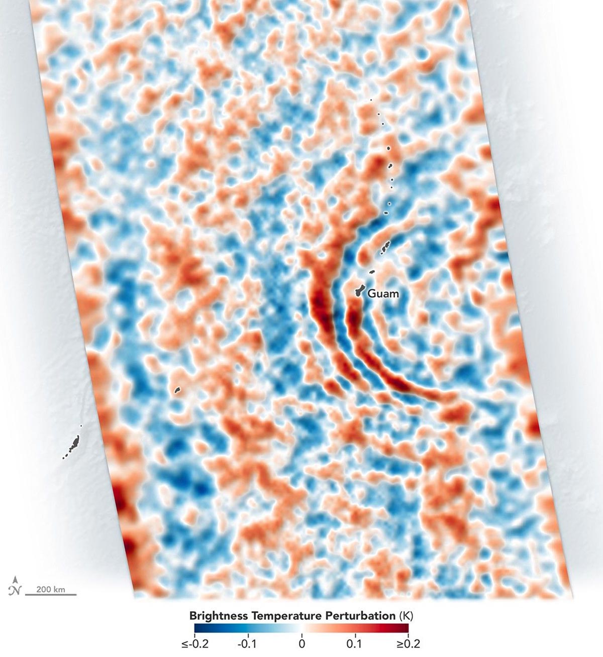
Gravity Waves Tracked Through Multiple Layers of the Atmosphere
The effects of Sinlaku’s gravity waves were observed at lower altitudes as well. NASA’s Aqua satellite, using the AIRS (Atmospheric Infrared Sounder) instrument, detected thermal emissions associated with gravity waves in the stratosphere on April 13.
Additional observations on April 14 showed the same rippling structures, indicating that the storm continued influencing the atmosphere even after the initial observations.
Why Gravity Waves Matter
Scientists say these observations are more than just visually striking.
According to Alexander, gravity waves could eventually help researchers better monitor storm intensification, especially over remote ocean regions where direct observations are limited.
“We’d like to use gravity waves to tell us if a storm is intensifying,” Alexander said, “which can be difficult to know, especially over the open ocean.”
She and her colleagues have suggested that future geostationary satellites equipped with suitable infrared instruments could continuously observe gravity waves and provide additional information about how tropical cyclones evolve.
From Weather Forecasts to Space Weather
The importance of gravity waves extends beyond hurricane monitoring. Laura Holt, also a senior research scientist at NorthWest Research Associates, said atmospheric processes in the stratosphere play an important role in weather prediction.
For example, wind patterns in the stratosphere can influence long-range forecasts for the Northern Hemisphere’s winter. Tropical cyclones can have an outsized impact because their intense and persistent convection generates gravity waves that continuously affect the stratosphere.
The influence of these waves can extend even farther, reaching the realm of space weather.
“For a while, people have seen signatures of hurricanes in ionospheric weather,” Holt said.
Gravity waves can trigger traveling ionospheric disturbances, which are large-scale fluctuations in plasma density. In some cases, they can also contribute to the formation of plasma bubbles. Both phenomena have the potential to interfere with satellite signals and radio communications.
“With space weather in particular,” Holt added, “a single event such as a tropical cyclone can be very important.”
NASA Earth Observatory images by Michala Garrison, using VIIRS day-night band data from NASA EOSDIS LANCE, GIBS/Worldview, and the Joint Polar Satellite System (JPSS), and AIRS data from Hoffmann, L.
Never miss a breakthrough: Join the SciTechDaily newsletter.
Follow us on Google and Google News.
1 Comment
Amazing information!