Typhoon Khanun approached China’s coast on the heels of Typhoon Doksuri, which left a trail of destruction in the days prior.
Following the devastation of Typhoon Doksuri in the Western Pacific, a new storm, Typhoon Khanun, threatens to cause further damage. The region, still recovering from Doksuri’s fatal impacts and extensive flooding, now prepares for another potential disaster.
Emerging Threat: Typhoon Khanun
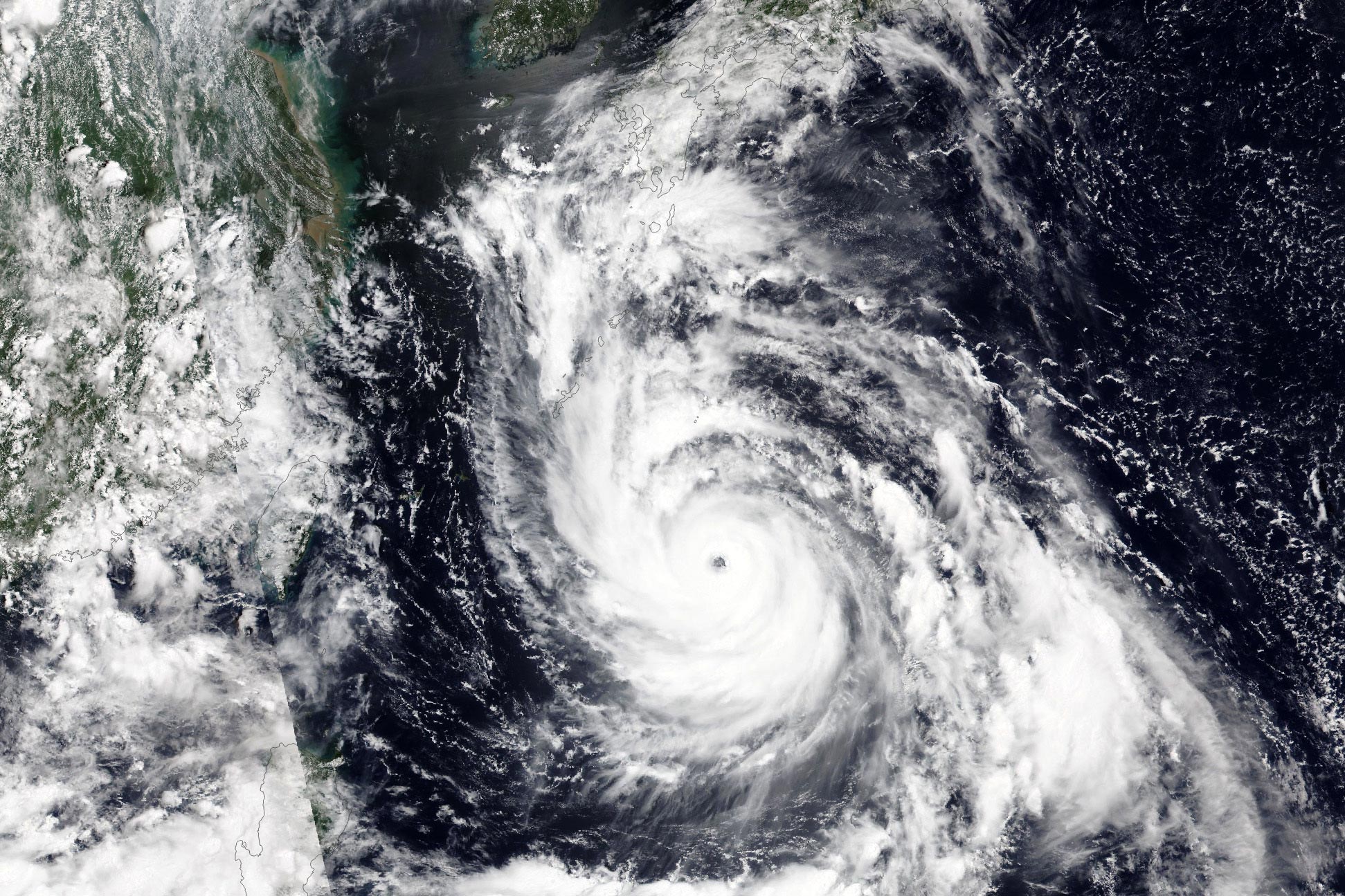
Just days after Typhoon Doksuri slammed the Philippines, Taiwan, and China, another potent storm was threatening more damage in the Western Pacific region. Typhoon Khanun was observed intensifying over the Pacific Ocean by the Visible Infrared Imaging Radiometer Suite (VIIRS) aboard the NOAA-20 satellite. The satellite captured the image above at 1:20 p.m. Japan Standard Time (4:20 Universal Time) on July 31, 2023.
Predictive models from the previous day suggested Khanun’s trajectory pointed at China’s coast, south of Shanghai, but moving more slowly than previously forecast. The typhoon was expected to slow or stall near Okinawa, Japan, before lingering offshore of China for several days. By 9 p.m. Japan Standard Time (12:00 Universal Time) on July 31, Khanun had reached category 4 on the Saffir-Simpson scale, with sustained winds of 130 miles per hour, reported Weather Underground.
Preparations and Potential Impact
Okinawa is bracing for a category 2 or stronger storm at its closest passage. This is expected sometime around August 1, and will bring heavy rain, strong winds, and storm tides. China could see a lower-intensity landfall several days later as Khanun creeps onward. Some models show it turning away from land after passing Okinawa. Still, China’s Zhejiang Province activated a Level IV emergency response—the lowest in its system—on July 30 in anticipation of storm surge.
The region has had scarce time to recover from the impacts of Typhoon Doksuri, which struck heavily populated areas south of Khanun’s path. The image below, acquired on July 27 by VIIRS on NOAA-20, shows the typhoon after it lashed the Philippines and before it reached China.
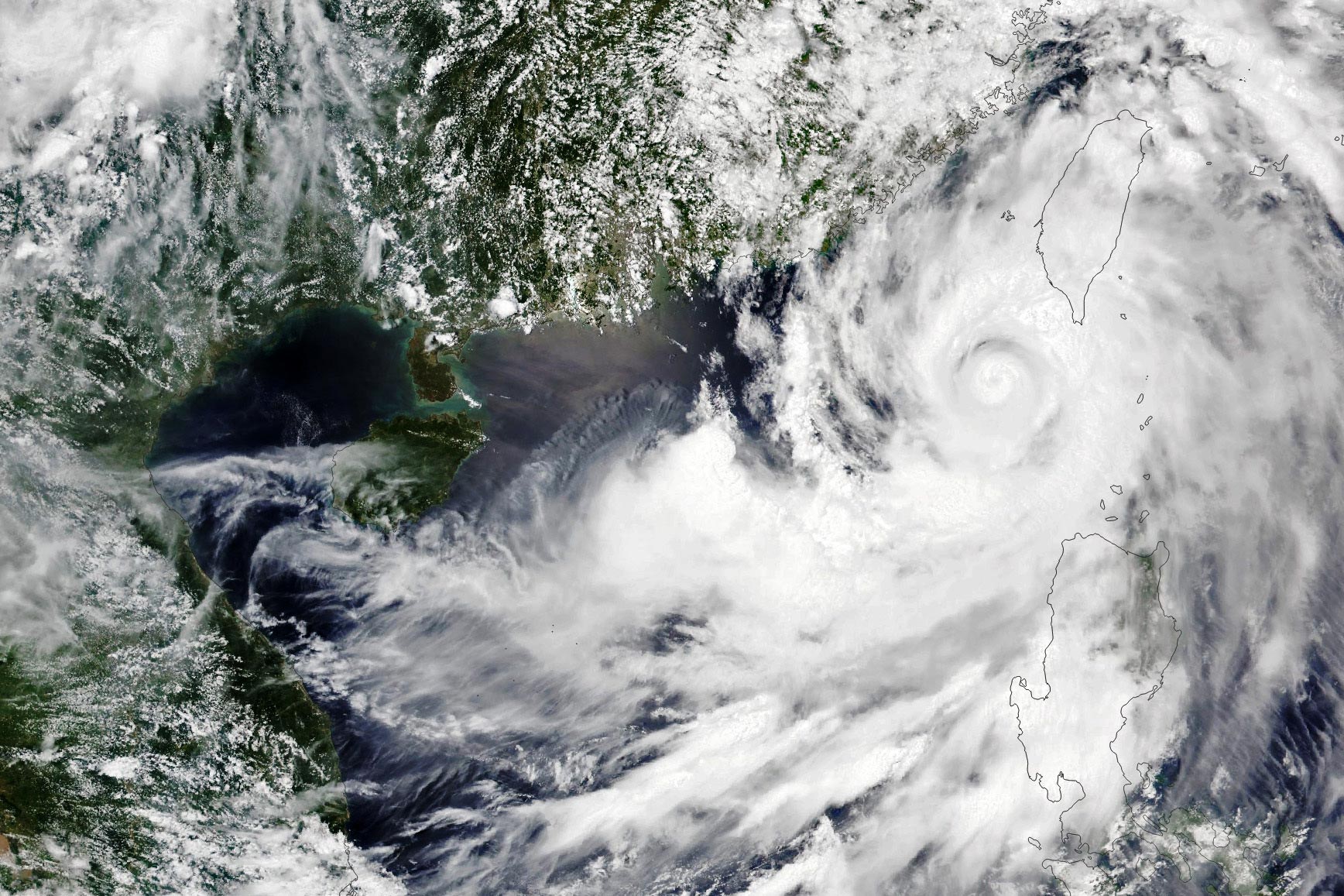
Aftermath of Typhoon Doksuri
Doksuri caused dozens of deaths in the Philippines, according to news reports, resulting from landslides, flooding, and a capsized passenger ship. Thousands more people were displaced. On Taiwan, the storm dropped up to 700 millimeters (28 inches) of rain in some areas.
The typhoon made landfall near the large cities of Xiamen and Quanzhou, China, on July 28 at about 10 a.m. local time. More than 400,000 people evacuated from coastal areas. From there, the relentless rains from Doksuri continued. The storm proceeded north in the ensuing days and caused severe flooding in Beijing, approximately 1,600 kilometers (1,000 miles) away from Quanzhou. The city recorded 177 millimeters (7 inches) of rain, and one station in the outlying district of Mentougou logged 580 millimeters (23 inches), according to news reports. The deluge damaged infrastructure and spurred evacuations and rescues.
Typhoons are rated based on their wind speed and potential for damage using the Saffir-Simpson Hurricane Wind Scale. This is a 1 to 5 rating, or category system, where each category corresponds to a different wind speed range and damage potential.
Here is the breakdown of the Saffir-Simpson scale:
- Category 1: Wind speeds of 74-95 mph (119-153 kph). Very dangerous winds will produce some damage.
- Category 2: Wind speeds of 96-110 mph (154-177 kph). Extremely dangerous winds will cause extensive damage.
- Category 3 (Major): Wind speeds of 111-129 mph (178-208 kph). Devastating damage will occur.
- Category 4 (Major): Wind speeds of 130-156 mph (209-251 kph). Catastrophic damage will occur.
- Category 5 (Major): Wind speeds of 157 mph (252 kph) or higher. Catastrophic damage will occur.
It’s important to note that this scale measures wind speed but does not take into account other factors that contribute to the overall severity of a storm, such as storm surge, rainfall totals, or the size of the storm. Therefore, even lower category storms can cause severe damage, especially in terms of flooding.
NASA Earth Observatory images by Wanmei Liang, using VIIRS data from NASA EOSDIS LANCE, GIBS/Worldview, and the Joint Polar Satellite System (JPSS).
Never miss a breakthrough: Join the SciTechDaily newsletter.
Follow us on Google and Google News.