Close Menu
    Facebook X (Twitter) Instagram
    SciTechDaily
    • Biology
    • Chemistry
    • Earth
    • Health
    • Physics
    • Science
    • Space
    • Technology
    Facebook X (Twitter) Pinterest YouTube RSS
    SciTechDaily
    Home»Earth»NASA Satellites View Super Typhoon Haiyan
    Earth

    NASA Satellites View Super Typhoon Haiyan

    By Alan Buis, Jet Propulsion Laboratory; NASANovember 11, 2013No Comments3 Mins Read
    Facebook Twitter Pinterest Telegram LinkedIn WhatsApp Email Reddit
    Share
    Facebook Twitter LinkedIn Pinterest Telegram Email Reddit
    NASA Aqua Spacecraft Captures Infrared Images of Super Typhoon Haiyan
    NASA’s Atmospheric Infrared Sounder (AIRS) instrument on NASA’s Aqua spacecraft captured these infrared images of Super Typhoon Haiyan at 8:59 p.m. PST November 7 (left) and 9:17 a.m. PST November 8 (right). The storm’s coldest cloud-top temperatures and areas of heaviest rainfall are depicted by the brightest shades of purple. Credit: NASA/JPL-Caltech

    New satellite data from NASA provide a glimpse into one of the most powerful storms ever recorded on Earth, Super Typhoon Haiyan.

    New satellite images just obtained from NASA’s Atmospheric Infrared Sounder (AIRS) instrument aboard NASA’s Aqua spacecraft and the Indian Space Research Organization’s OceanSAT-2 ocean wind scatterometer provide a glimpse into one of the most powerful storms ever recorded on Earth.

    According to the U.S. Navy Joint Typhoon Warning Center, Typhoon Haiyan had maximum sustained winds of 195 mph (314 kilometers per hour), with gusts up to 235 mph (379 kilometers per hour) shortly before making landfall in the central Philippines today. That would make it one of the strongest storms ever recorded. Weather officials in the Philippines reported the storm, known locally as Typhoon Yolanda, came ashore with maximum sustained winds of 147 mph (235 kilometers per hour) and gusts of up to 170 mph (275 miles per hour).

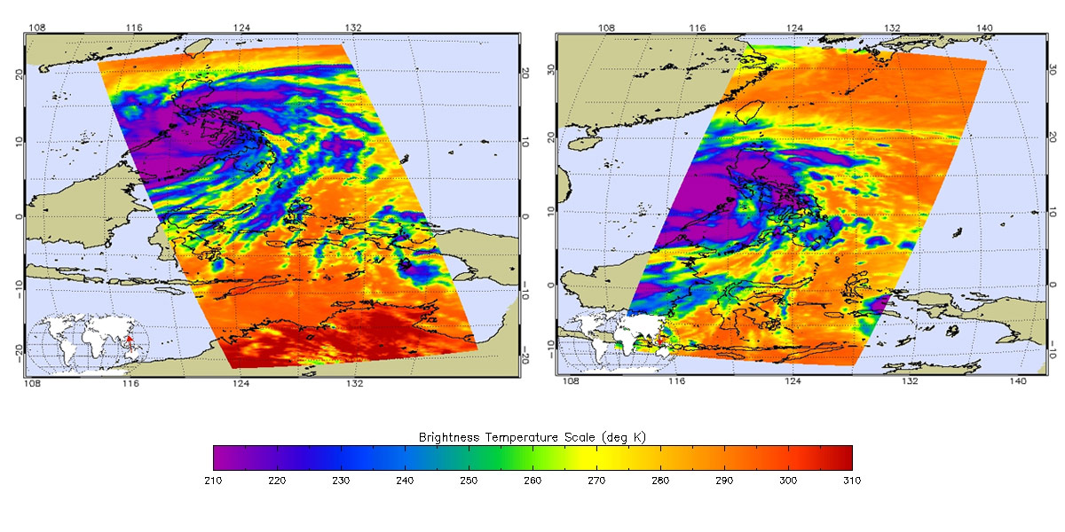
    The two AIRS images, acquired at 8:59 p.m. PST on November 7 (left) and 9:17 a.m. PST on November 8 (right), show the powerful storm in infrared. When the image on the left was acquired, the storm was located 214 miles (344 kilometers) south-southeast of Manila. By the time the image on the right was acquired, the fast-moving storm was already centered west of the Philippines, on a forecast track that will take it to Vietnam. The storm’s coldest cloud-top temperatures are indicated by the brightest shades of purple, and show where Haiyan’s heaviest rainfall was occurring.

    Super Typhoon Haiyan Ocean Surface Winds Measured by the OSCAT Radar
    Super Typhoon Haiyan’s ocean surface winds were measured by the OSCAT radar scatterometer on the Indian Space Research Organization’s OceanSAT-2 satellite at 5:30 p.m. PST on November 6. The colors indicate wind speed and arrows indicate wind direction. Credit: ISRO/NASA/JPL-Caltech

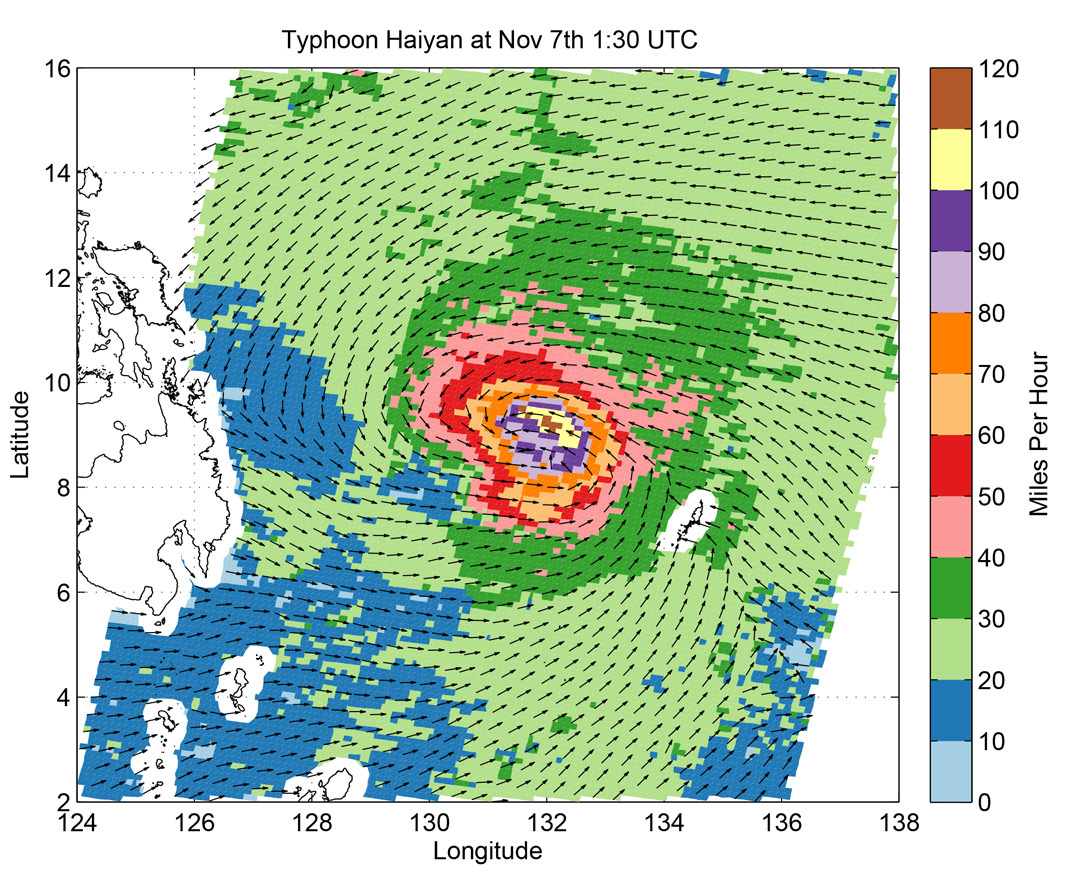
    Another image, from the OSCAT radar scatterometer on the Indian Space Research Organization’s OceanSAT-2 satellite, shows Haiyan’s ocean surface winds at 5:30 p.m. PST on November 6. The wind data were calculated by scientists at NASA’s Jet Propulsion Laboratory, Pasadena, California, using an advanced wind retrieval algorithm designed for tropical cyclone conditions. The colors indicate wind speed and arrows indicate wind direction. The wind speeds were measured in 15-by-15-mile (24-by-24-kilometer) boxes that recorded a maximum value of 128 miles, or 206 kilometers, per hour). That’s why these wind speeds are lower than the maximum small-scale winds calculated by the U.S. Navy Joint Typhoon Warning Center.

    For more information on AIRS, visit: http://airs.jpl.nasa.gov/.

    Never miss a breakthrough: Join the SciTechDaily newsletter.
    Follow us on Google and Google News.

    JPL NASA Planetary Science Weather
    Share. Facebook Twitter Pinterest LinkedIn Email Reddit

    Related Articles

    NASA’s Atmospheric Infrared Sounder Tracks Record-Breaking Heat Wave in Pacific Northwest

    Prior Weather Linked to Rapid Intensification of Hurricanes Near Landfall

    NASA Using Machine-Learning AI to Predict Hurricane Intensity

    California’s Intense Record-Breaking Heat Wave Monitored From NASA’s ECOSTRESS

    NASA’s Atmospheric Infrared Sounder Tracks Hurricane Douglas, Tropical Storm Hanna From Space

    NASA’s Atmospheric Infrared Sounder Monitors Tropical Storm Fay as It Deluges the East Coast

    New NASA/NOAA Animations Reveal Water Vapor Over Oceans

    AIM Monitors Electric-Blue Noctilucent Clouds over Antarctica

    NASA Satellite Image Shows La Niña Peaking in Intensity

    Leave A Reply Cancel Reply

    • Facebook
    • Twitter
    • Pinterest
    • YouTube

    Don't Miss a Discovery

    Subscribe for the Latest in Science & Tech!

    Trending News

    Scientists Uncover Potential Brain Risks of Popular Fish Oil Supplements

    Scientists Discover a Surprising Way To Make Bread Healthier and More Nutritious

    After 60 Years, Scientists Uncover Unexpected Brain Effects of Popular Diabetes Drug Metformin

    New Research Uncovers Hidden Side Effects of Popular Weight-Loss Drugs

    Scientists Rethink Extreme Warming After Surprising Ocean Discovery

    Landmark Study Links Never Marrying to Significantly Higher Cancer Risk

    Researchers Discover Unknown Beetle Species Just Steps From Their Lab

    Largest-Ever Study Finds Medicinal Cannabis Ineffective for Anxiety, Depression, PTSD

    Follow SciTechDaily
    • Facebook
    • Twitter
    • YouTube
    • Pinterest
    • Newsletter
    • RSS
    SciTech News
    • Biology News
    • Chemistry News
    • Earth News
    • Health News
    • Physics News
    • Science News
    • Space News
    • Technology News
    Recent Posts
    • Not Just Alzheimer’s: Scientists Uncover Clues to a Second, Overlooked Disorder
    • Scientists Uncover Dangerous Connection Between Serotonin and Heart Valve Disease
    • Scientists Discover a “Protector” Protein That Could Help Reverse Hair Loss
    • Powerful Lasers Reveal How Matter Becomes Plasma in Trillionths of a Second
    • A Simpler Path to Super-Resolution: Scientists Reinvent Microscopy
    Copyright © 1998 - 2026 SciTechDaily. All Rights Reserved.
    • Science News
    • About
    • Contact
    • Editorial Board
    • Privacy Policy
    • Terms of Use

    Type above and press Enter to search. Press Esc to cancel.