In the Utah desert, the red rocks, cliffs, and canyons of this nautically named national park—and many of its famous fossils—owe their existence to water.
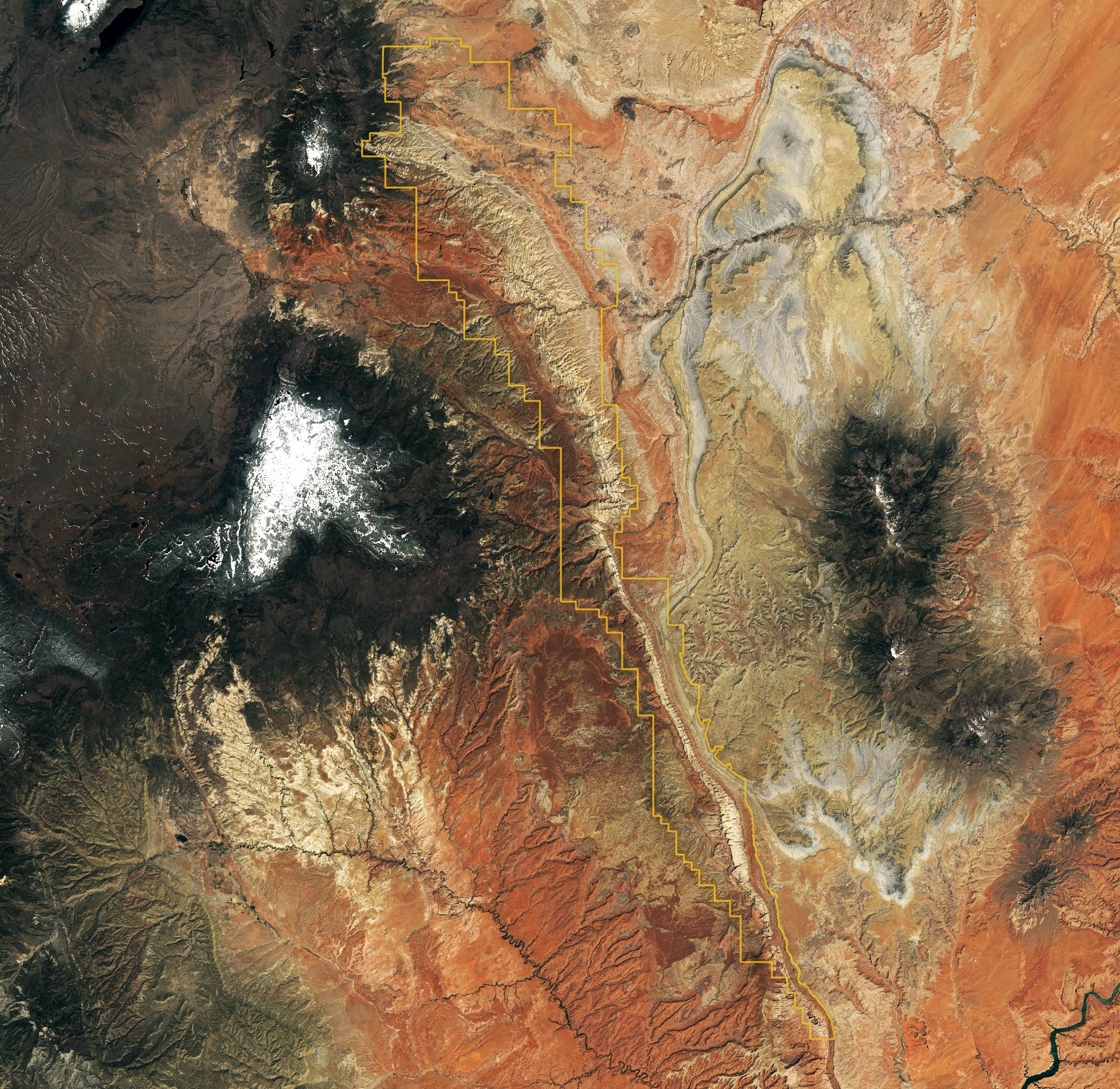
Capitol Reef National Park in south-central Utah is not home to either a capitol or a reef. It was named instead for two geologic features: the prominent white domes of Navajo Sandstone, which reminded early settlers of the Capitol Building in Washington, D.C.; and a formidable ridge of rocky cliffs that presented a barrier to passage. The settlers (some likely traveling in prairie schooners) compared it to the maritime navigational hazard of an ocean reef.
The ridge, called Waterpocket Fold, runs north-south for 90 miles (140 kilometers). It is visible in the image above, which was acquired on May 2, 2022, by the Landsat 9’s Operational Land Imager-2 (OLI-2).
The ridge is named for a common feature in the park. Waterpockets are natural depressions or pockets—eroded from the rock—that collect rainwater and snowmelt, a precious source of freshwater for humans and wildlife in the desert. Geologically, Waterpocket Fold is a monocline, a structure in which the rock layers have been folded up or down on one side. (Structures in which the rock layers are folded on both sides—either bent up like a U-shaped smile or down like frown—are called synclines and anticlines, respectively.)
Formation of the Waterpocket Fold
Between 75 million and 35 million years ago, the tectonic forces that uplifted the Rocky Mountains also buckled older rocks below Capitol Reef. The rock layers above did not break, but bent, like a tablecloth draped over a table edge. The bend in this drape forms the Waterpocket Fold. More recently, rains, flash floods, and freeze-thaw cycles have eroded and sculpted the cliffs, canyons, bridges, and domes into what we see today.
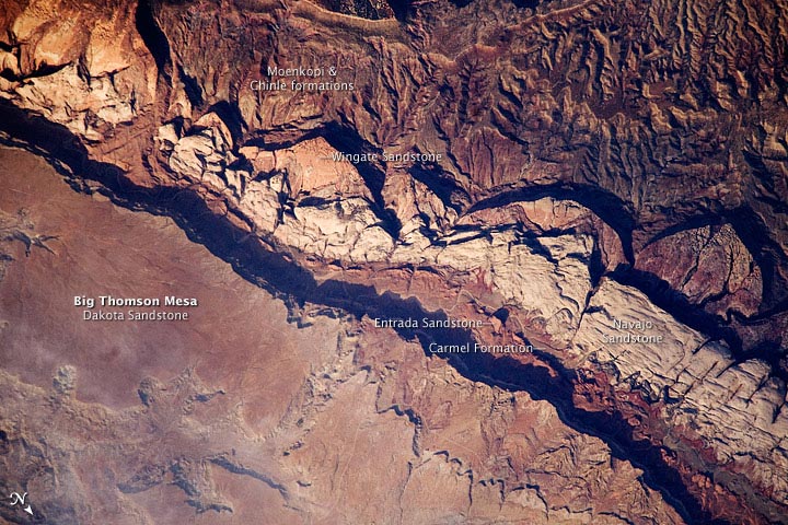
Capitol Reef tells a geologic story of hundreds of millions of years of deposition, uplift, and erosion—punctuated by episodes of volcanism and glaciation. The park boasts a nearly complete series of rock layers spanning from the late Permian Period (about 290 million years ago) to the end of the Mesozoic Era (66 million years ago). Deposited along and in a shallow sea and ancient delta, these rocks hold a nearly continuous record of life and environments here from before the rise of the dinosaurs through their demise.
Today, they are some of the most well-known rocks of the Colorado Plateau, including the Moenkopi, Chinle, Navajo, Entrada, and Dakota formations. Several of these are visible in the below image of Big Thomson Mesa within Capitol Reef. The photograph was taken on June 14, 2009, by the crew on the International Space Station.
Capitol Reef also hosts part of the largest and oldest fossil megatracksite in North America. These are mostly trace fossils, or ichnofossils, found in the Moenkopi Formation, which formed in the Early Triassic Period, about 240 million years ago. Unlike body fossils, trace fossils are the marks or other evidence that ancient life left behind—like footprints, burrows, and even feces (coprolites). Many of the trackways at Capitol Reef were formed when fish dragged their fins or reptiles scraped their feet, toes, or claws as they swam along an ancient shoreline or traversed a tidal mudflat. The impressions that they left were later filled with sand, which hardened into sandstone, forming casts.
In May 2022, park officials reported the loss of part of a rare fossil trackway. After posting a photo of a rock outcrop on social media, park officials were alerted to the missing tracks by a paleontologist who was familiar with the site. An examination of previous photos of the site revealed the fossils had been removed sometime between August 2017 and August 2018.
NASA Earth Observatory image by Lauren Dauphin, using Landsat data from the U.S. Geological Survey. Astronaut photograph ISS020-E-9861 was acquired on June 14, 2009, with a Nikon D3 digital camera fitted with an 800 mm lens, and is provided by the ISS Crew Earth Observations experiment and Image Science & Analysis Laboratory, Johnson Space Center. The image was taken by the Expedition 20 crew. The image in this article has been cropped and enhanced to improve contrast. Lens artifacts have been removed. The International Space Station Program supports the laboratory to help astronauts take pictures of Earth that will be of the greatest value to scientists and the public, and to make those images freely available on the Internet.
Never miss a breakthrough: Join the SciTechDaily newsletter.
Follow us on Google and Google News.