
Satellite view of tornado damage across Greenfield, Iowa captured on May 25, 2024, by the Operational Land Imager on Landsat 8.
During one of the most active U.S. tornado seasons, a powerful EF-4 tornado devastated Greenfield, Iowa, with winds of 185 mph. The destructive tornado destroyed homes, downed wind turbines and power lines, snapped trees, and shredded roofs.
It’s been one of the busiest U.S. tornado seasons in years. As of May 28, National Weather Service meteorologists have confirmed 875 tornadoes. One of the strongest and most destructive was a powerful twister that formed in southwestern Iowa on May 21, 2024. The tornado drew a line of destruction for nearly 44 miles and cut through the town of Greenfield, Iowa.
The tornado was one of a rash of twisters that formed when a cold front produced a line of strong thunderstorms that tracked through the Midwest. An especially large and tall storm with rotating updrafts (a supercell) produced an EF-4 tornado, which hit Greenfield with peak winds of 185 miles (300 kilometers) per hour.
Damage Assessment
The path of damage across Greenfield is visible in the image above, acquired on May 25, 2024, with the OLI (Operational Land Imager) on Landsat 8. According to storm reports posted by NOAA’s Storm Prediction Center, the deadly twister destroyed homes, downed wind turbines and power lines, snapped trees, and shredded roofs.
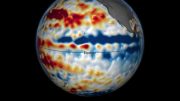
Satellite images of the storm system that preceded the tornado offered subtle clues of the destruction to come. The brightness temperature data shown below, acquired with the MODIS (Moderate Resolution Imaging Spectroradiometer) on NASA’s Aqua satellite, was collected about an hour before the tornado struck Greenfield. White and light-purple cloud tops are cooler than dark-purple and yellow surfaces.

Brightness temperature data captured on May 21, 2024, by the Moderate Resolution Imaging Spectroradiometer on NASA’s Aqua satellite.
Significance of Cloud Formations
Notice the cooler (whiter) areas of the cloud surfaces. These are overshooting cloud tops—dome-like protrusions from thunderstorm clouds that are driven by convective updrafts. These cloud tops can rise past the tropopause and the anvil portion of a thunderstorm cloud, sometimes punching into the lower stratosphere.
According to Kristopher Bedka, an atmospheric scientist at NASA’s Langley Research Center, the overshooting top southwest of Greenfield was the coldest and largest one present across Iowa at the time. “This signifies a well-organized storm with a strong updraft,” Bedka said. “When this type of updraft ingests a very unstable airmass with large vertical wind shear, catastrophic tornadoes and large hail are often the result.”
Advances in Storm Prediction
Researchers closely watch for overshooting clouds and other features that herald tornadoes, destructive hail, and bouts of extreme lightning. Bedka and other NASA scientists have developed automatic and innovative techniques for quickly identifying such features in satellite imagery.
“We have applied these techniques to long-term geostationary satellite data records to quantify severe storm frequency and risk,” Bedka added. “This has made it possible for us to provide the reinsurance industry with new and highly detailed insights into severe storm activity and risk that are especially valuable in developing countries without weather radar coverage.”
NASA Earth Observatory images by Michala Garrison, using Landsat data from the U.S. Geological Survey, and MODIS data from NASA EOSDIS LANCE and GIBS/Worldview.


Be the first to comment on "Twisting Fury: The Science Behind the EF-4 Tornado That Ravaged Iowa"