
Close Menu
    Facebook X (Twitter) Instagram
    SciTechDaily
    • Biology
    • Chemistry
    • Earth
    • Health
    • Physics
    • Science
    • Space
    • Technology
    Facebook X (Twitter) Pinterest YouTube RSS
    SciTechDaily
    Home»Earth»Exploring Earth From Space: Majestic View of Lofoten, Norway [Video]
    Earth

    Exploring Earth From Space: Majestic View of Lofoten, Norway [Video]

    By European Space Agency (ESA)March 11, 2022No Comments3 Mins Read
    Facebook Twitter Pinterest Telegram LinkedIn WhatsApp Email Reddit
    Share
    Facebook Twitter LinkedIn Pinterest Telegram Email Reddit
    Lofoten Norway Crop
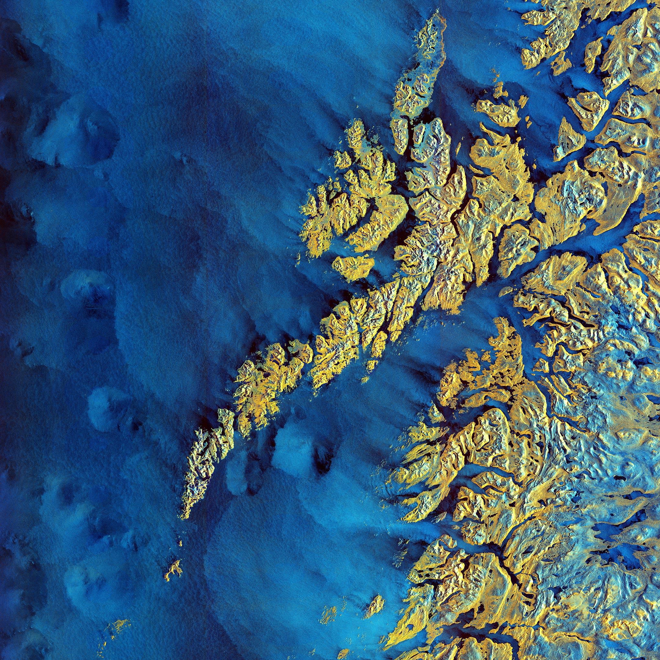
    The archipelago of Lofoten in northern Norway captured by the Copernicus Sentinel-1 mission on November 24, 2020. (Image is cropped. Click for the full view.) Credit: Contains modified Copernicus Sentinel data (2020), processed by ESA, CC BY-SA 3.0 IGO

    The Copernicus Sentinel-1 mission takes us over the archipelago of Lofoten in northern Norway.

    Extending around 175 km (109 mi) from north to south, the archipelago comprises five main islands (Austvågøya, Gimsøya, Vestvågøya, Flakstadøya, and Moskenesøya), as well as many small islands and skerries (rocky islets and reefs). Lofoten is known for its distinctive scenery, with dramatic mountains and peaks, sweeping beaches, deep blue fjords, and sheltered bays.

    Svolvær, the chief town and port of the Lofoten island group, is located on the southern coast of Austvågøya, the easternmost island of the archipelago. The economy largely depends on cod fisheries, with the town’s population swelling during the spawning season as fishermen flock in. The fjord of Vestfjorden lies between the archipelago and the mainland.

    Although lying entirely within the Arctic Circle, Lofoten experiences one of the world’s largest elevated temperature anomalies relative to its high latitude. Due to a convergence of the Gulf Stream with two underwater currents, the North Atlantic Current and the Norwegian Current, the weather in Lofoten remains anomalously warm.

    The colors of this week’s image come from the combination of two ‘polarisations’ from the Copernicus Sentinel-1 mission which have been converted into a single image. This remote sensing technique allows us to detect where differences between the polarisations are higher. These differences are visible in shades of blue in the image, such as the choppy Norwegian Sea, wetlands and mires such as those on the northern tip of Andøya, and wet snow on hilltops and in mountains (bottom-right corner of the image).

    What appears in yellow indicates what has fewer differences between polarisations, such as forests and other vegetated land, as well as built-up areas.

    Sentinel-1 is a radar mission and unlike optical cameras, the images are usually black and white when they are received. By using a technology that aligns the radar beams sent and received by the instrument in one orientation – either vertically or horizontally – the resulting data can be processed in a way that produces colored images such as the one featured here. This technique allows scientists to better analyze Earth’s surface. For more information on polarimetry, click here.

    This image, acquired on November 24, 2020, is also featured on the Earth From Space video program embedded above.

    Never miss a breakthrough: Join the SciTechDaily newsletter.
    Follow us on Google and Google News.

    European Space Agency Geography
    Share. Facebook Twitter Pinterest LinkedIn Email Reddit

    Related Articles

    Breathtaking View of Andros, Bahamas From Space [Video]

    Stunning Views of Houston Texas From Copernicus Sentinel-1 Satellite

    Earth From Space: Bolivian Highland Heart [Video]

    Flevoland, Netherlands From Space: One of the Largest Land Reclamation Projects in the World

    Earth From Space: Lake George, Uganda – A Center for Biological Diversity [Video]

    Deforestation in Bolivia Spied From Space Satellite

    Earth From Space: Japanese Archipelago [Video]

    Earth From Space: Faroe Islands [Video]

    Earth From Space: Tromsø, Norway [Video]

    Leave A Reply Cancel Reply

    • Facebook
    • Twitter
    • Pinterest
    • YouTube

    Don't Miss a Discovery

    Subscribe for the Latest in Science & Tech!

    Trending News

    These Toads Are Surviving a Deadly Fungus – Scientists May Finally Know Why

    These Brain Cells May Explain Why We Eventually Have To Sleep

    Tomatoes Contain an Invisible Ingredient With Surprising Effects on Liver Health

    World’s First Heat-Powered Cooling System Turns Waste Heat Into Cold

    Antarctica Gained a Record 695 Billion Tons of Ice in Just Two Years

    Don’t Miss: A Brilliant Venus and Glowing Harvest Moon Light Up the Sky

    New Twist on the Einstein Problem Reveals Unexpected Physics

    JWST Captures Stunning Evidence of How Supermassive Black Holes Feed

    Follow SciTechDaily
    • Facebook
    • Twitter
    • YouTube
    • Pinterest
    • Newsletter
    • RSS
    SciTech News
    • Biology News
    • Chemistry News
    • Earth News
    • Health News
    • Physics News
    • Science News
    • Space News
    • Technology News
    Recent Posts
    • Scientists Bring a Galápagos Plant Back From the Brink of Extinction
    • Scientists Discover a Bacterial Molecule That “Disarms” a Dangerous Fungus
    • Bats May Hold the Secret to Fighting Aging, Cancer, and Infection
    • Scientists Discover a Hidden Defect That Could Explain Why IBD Keeps Coming Back
    • Millions Take Blood Pressure Drugs, but Many May Be Missing Their Heart-Protective Benefits
    Copyright © 1998 - 2026 SciTechDaily. All Rights Reserved.
    • Science News
    • About
    • Contact
    • Editorial Board
    • Privacy Policy
    • Terms of Use

    Type above and press Enter to search. Press Esc to cancel.