
Close Menu
    Facebook X (Twitter) Instagram
    SciTechDaily
    • Biology
    • Chemistry
    • Earth
    • Health
    • Physics
    • Science
    • Space
    • Technology
    Facebook X (Twitter) Pinterest YouTube RSS
    SciTechDaily
    Home»Earth»Melting Majesty: Quelccaya’s Ice Cap Shrinks in Climate’s Grip
    Earth

    Melting Majesty: Quelccaya’s Ice Cap Shrinks in Climate’s Grip

    By Kathryn Hansen, NASA Earth ObservatoryNovember 28, 2023No Comments4 Mins Read
    Facebook Twitter Pinterest Telegram LinkedIn WhatsApp Email Reddit
    Share
    Facebook Twitter LinkedIn Pinterest Telegram Email Reddit
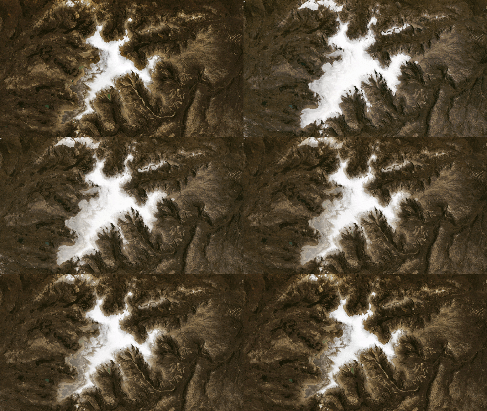
    Quelccaya Ice Cap 1998 2023
    The Quelccaya Ice Cap in Peru has dramatically shrunk from 58 to 40 square kilometers between 1988 and 2023 due to climate change. This retreat is causing the loss of historical climate data preserved in the ice and significant environmental changes, including the formation of meltwater lakes and glacial floods.

    Ice cores and satellite images are helping preserve the history of a disappearing ice cap in the Peruvian Andes.

    The Quelccaya Ice Cap rests on a high-altitude plateau of the Andes Mountains in Peru. But like other tropical glaciers across the planet, the comparatively cold temperatures found at high altitudes are not enough to protect it from the grip of climate change.
    Quelccaya Ice Cap 1998 Annotated
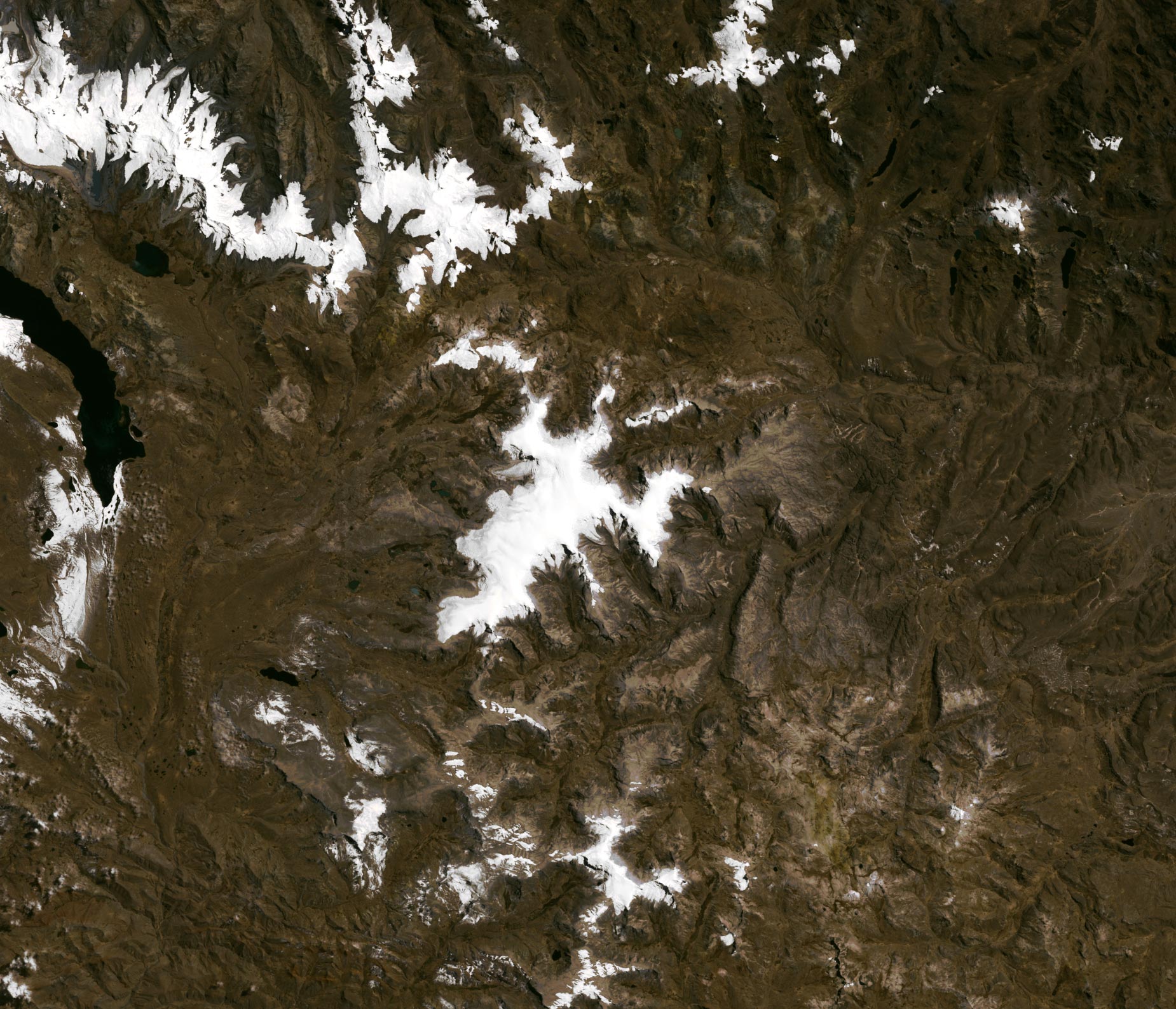
    Satellite image of the Quelccaya Ice Cap captured on September 3, 1988, by the Thematic Mapper on Landsat 5.

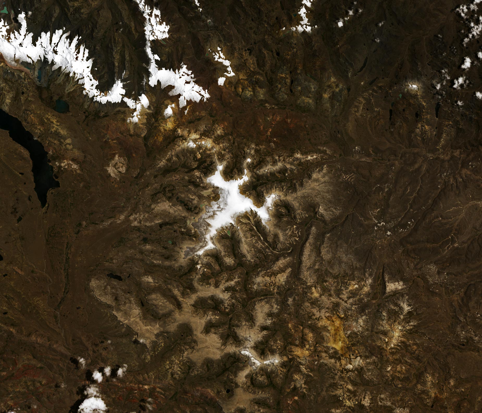
    This image pair shows the retreat of Quelccaya’s ice edge between September 3, 1988 (above), and October 22, 2023 (below). They were acquired with the TM (Thematic Mapper) on Landsat 5 and the OLI (Operational Land Imager) on Landsat 8, respectively. Christopher Shuman, a University of Maryland, Baltimore County, glaciologist based at NASA’s Goddard Space Flight Center, estimates that the ice area in 1988 spanned about 58 square kilometers (22 square miles); by 2023, it spanned just over 40 square kilometers (15 square miles).

    Notice the accrual of meltwater lakes in the later image, particularly along the ice cap’s western side. Many of these lake basins, carved by moving ice, have lost contact with the ice that formed them. The ice cap also feeds the Vilcanota River and Lake Sibinacocha (west of this image) and has long been an important water source for people living nearby and downstream.
    Quelccaya Ice Cap 2023 Annotated
    Satellite image of the Quelccaya Ice Cap captured on October 22, 2023, by the Operational Land Imager on Landsat 8.

    Some of the lakes have already come and gone during the span of these images, including one that in November 2022 produced a glacial lake outburst flood (GLOF). Shuman detected the event in Landsat images showing the emptying of a lake on the ice cap’s eastern side and a long path where the rushing floodwater had scoured the vegetation. The flood scar is still visible in this 2023 image.

    Before Landsat satellites revealed the decadal changes, scientists already knew the ice cap was shrinking. Since 1974, Lonnie Thompson and colleagues from Ohio State University have been mounting expeditions to study Quelccaya up close.

    “Both ground-based and satellite images allow the documentation of the rates of glacier retreat, which now average about 14 meters per year,” Thompson said. Thompson’s team has shared Landsat images documenting the ice cap’s retreat with local officials and indigenous people living near the ice cap.

    As the planet’s tropical glaciers are being lost, so are the temperature and climate records long preserved in their ice. Thompson’s team has drilled ice cores from many tropical glaciers, including Quelccaya. By analyzing the layers in these cores, scientists can get a near-annual record of air temperatures and atmospheric composition dating back 1,800 years.

    “Tropical glaciers might represent our only opportunity to capture global mean temperature changes through time, as well as how climate and the environment have changed in an area that represents 50 percent of the surface area of our planet and where over 50 percent of our 8 billion people live,” Thompson said.

    At Quelccaya, that record could be gone by the end of the 21st century—the expected timeframe for the ice cap’s demise. “The only proof of its existence will be the land-based and satellite images of what was once a magnificent ice cap located directly above the Amazon Basin.”

    NASA Earth Observatory images by Wanmei Liang, using Landsat data from the U.S. Geological Survey.

    Never miss a breakthrough: Join the SciTechDaily newsletter.
    Follow us on Google and Google News.

    Climate Change Geography NASA NASA Earth Observatory
    Share. Facebook Twitter Pinterest LinkedIn Email Reddit

    Related Articles

    Svalbard Crisis: Glaciers Melt at Unprecedented Rates As Temperatures Soar

    Vanishing Waters: The Stark Transformation From Aral Sea to Aralkum Desert

    Inferno on the Range: Texas Panhandle Firestorm in the Satellite Age

    Melting Mysteries: The Loss of Earth’s Frozen Records

    Antarctica Unpinned: Unlocking the Secrets of Thinning Ice Shelves

    Alarming Shrinkage of Norway’s Ålfotbreen Glacier – “Cannot Survive the Current Climate”

    Shrinking Glaciers and Growing Lakes As Temperatures Rise on the Tibetan Plateau

    A New Artificial Island: Preparing for Rising Seas in the Maldives

    Reshaping Coastal Louisiana: Barataria Bay Is Slowly Slipping Away

    Leave A Reply Cancel Reply

    • Facebook
    • Twitter
    • Pinterest
    • YouTube

    Don't Miss a Discovery

    Subscribe for the Latest in Science & Tech!

    Trending News

    This Experimental Drug Repaired the Gut and Reversed Severe Fatty Liver Disease

    Physicists Just Turned a Black Hole Energy Theory Into Reality

    Stanford Scientists Solve a 252-Million-Year-Old Mass Extinction Mystery

    The Ancient Survival Mechanism Making Weight Loss So Difficult

    Just 3,000 Steps a Day May Help Protect the Brain From Alzheimer’s

    “Weird Clams” Reveal a New Invasion Along the U.S. Northeast Coast

    Archaeologists Decapitated Tutankhamun and Glued His Body Back Together

    New Black Hole Theory Solves a 50-Year-Old Problem

    Follow SciTechDaily
    • Facebook
    • Twitter
    • YouTube
    • Pinterest
    • Newsletter
    • RSS
    SciTech News
    • Biology News
    • Chemistry News
    • Earth News
    • Health News
    • Physics News
    • Science News
    • Space News
    • Technology News
    Recent Posts
    • Scientists Restore the Sense of Touch With Electrical Brain Stimulation
    • New Study Reveals Herpesvirus Infection May Accelerate Alzheimer’s Disease
    • Microplastics Found in 84% of Serious Heart Attack Patients
    • The Oldest Known Right-Handed Animal May Have Lived 550 Million Years Ago
    • MIT’s Tiny Flying Robot Just Learned To Move Like a Real Insect
    Copyright © 1998 - 2026 SciTechDaily. All Rights Reserved.
    • Science News
    • About
    • Contact
    • Editorial Board
    • Privacy Policy
    • Terms of Use

    Type above and press Enter to search. Press Esc to cancel.