Ranchers in the Texas Panhandle recently faced a fire that charred more than 1 million acres.
The Texas Panhandle is a sparsely populated region of rolling hills, oil and gas wells, and grazing lands. By some estimates, 85 percent of the 12 million cattle raised in Texas live on ranches in the Panhandle.
Following a period of record winter heat, a storm system carrying dry, gusty winds moved through the region in late February and early March. These red flag weather conditions helped fuel wildland fires that tore through pastures and grasslands, damaged homes, and killed cattle.
Fire Detection and Analysis
NASA satellites first detected fires in the region on February 24, with widespread fire activity emerging on February 26 and 27. By March 5, the Smokehouse Creek fire had charred more than 1 million acres (4,000 square kilometers), making it the largest fire on record in Texas. Several other nearby fires raged in the Panhandle at the same time, including the Windy Deuce fire, Grape Vine Creek fire, and Magenta fire. Together, the four fires had charred more than 1.24 million acres by March 5, according to data published by InciWeb.
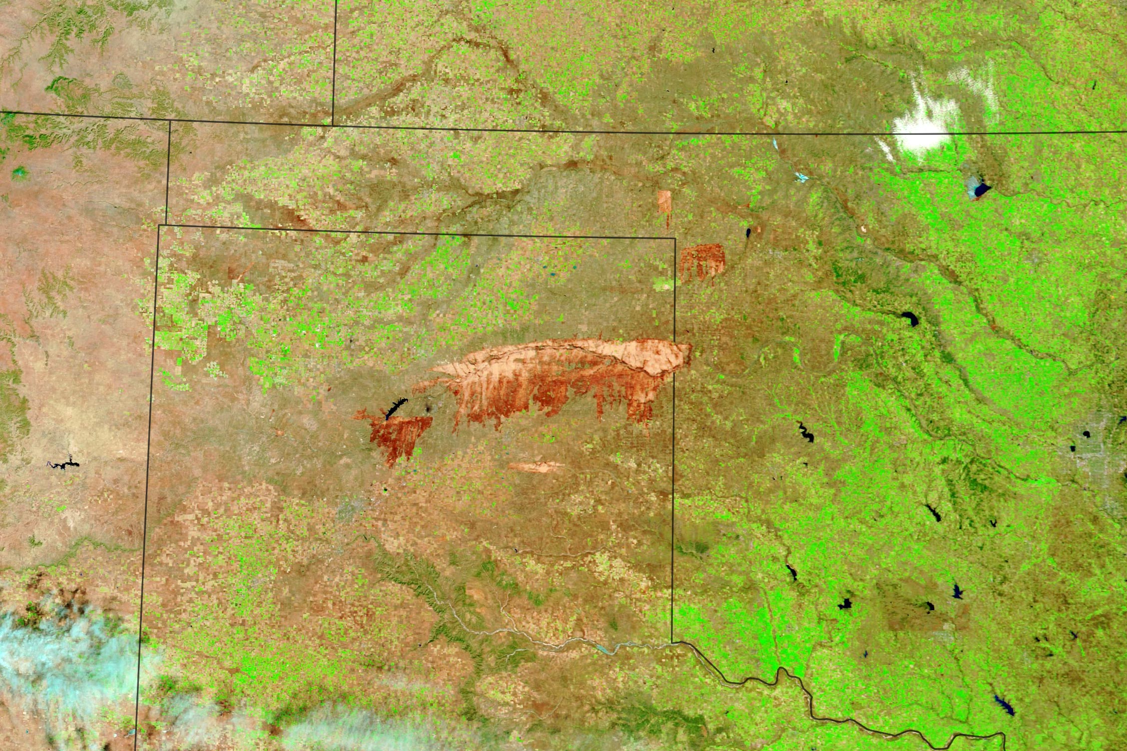
On March 2, 2024, the MODIS (Moderate Resolution Imaging Spectroradiometer) on NASA’s Terra satellite acquired this false-color image (bands 7-2-1) of the burn scar left on the Panhandle landscape. Most burned areas appear dark brown. In parts of the scar along the Canadian River, the fire exposed sandy deposits that appear light brown.
On the same day, the OLI (Operational Land Imager) on Landsat 8 captured a more detailed view (below) of part of the burn scar left by the Windy Deuce fire. The image shows charred landscapes around Fritch and Lake Meredith. Among the areas that burned were grazing lands, park lands, and areas with oil and gas development. The small white squares are drill pads.
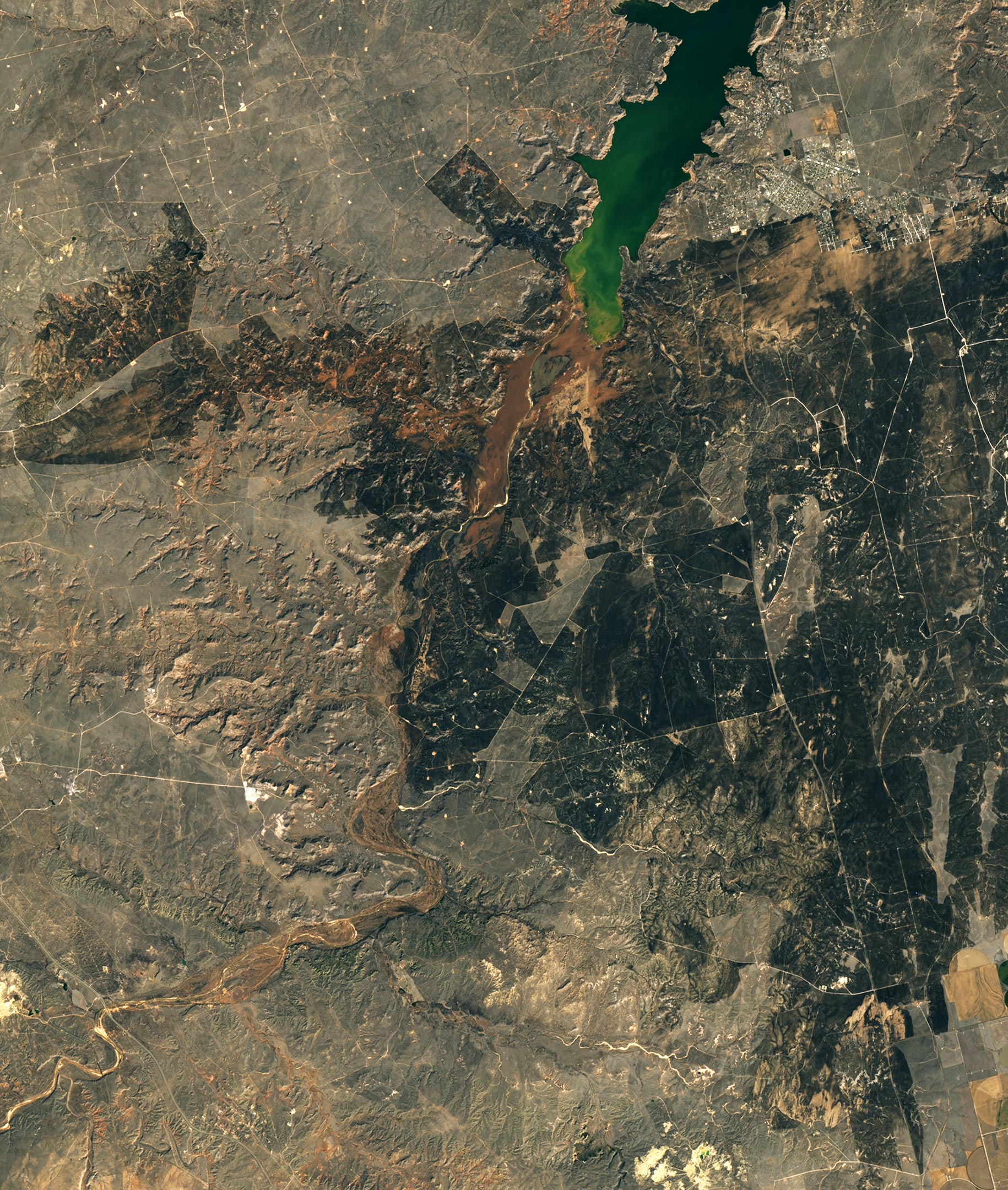
Some parts of the burn scar visible in the Landsat image were likely caused by backfires—blazes lit ahead of the fire front to help protect valuable areas such as homes, oil infrastructure, or farm infrastructure. “The straight edges in the burn scar generally indicate that an edge of some sort was defended by fighters, often roads or trails, but sometimes a tilled or bladed line in grasslands,” explained Carol Baldwin, a fire scientist with the Great Plains Fire Science Exchange. “A backfire is lit along the road and allowed to move toward the wildfire, thus depriving it of fuel and encouraging it to go out.”
Red flag warnings and grass fires are common in the Texas Panhandle in late-February and March. The region was primed for fire this year due to a prolonged drought that has affected the region in recent months and years, parching vegetation and making it easier for fires to spread. “The drought likely made this wildfire more challenging to fight,” said Jessica McCarty, the chief of the biospheric branch at NASA’s Ames Research Center. “Climate change will increasingly make severe fire weather days the standard in late winter and early spring moving forward. Local communities will have to focus on fire prevention, like reducing or eliminating human-caused ignitions to prevent this type of fire from happening in the future.”
Impact and Response
While most cattle survived the fires in barns or holding pens, some may be injured and communities have reported thousands of missing or dead cattle. “Cattle and crop losses in the Panhandle are significant and infrastructure damage is catastrophic,” the Texas Department of Agriculture said in a statement. Ranchers who were able to save their cattle from the flames have to confront a new problem—how to feed and care for animals after so much pasture and so many fences have burned. “This is calving season across the U.S., so some of the animals lost were likely calves or pregnant cows,” McCarty said. “The economic impact of this fire on agricultural communities could be severe.”
As of March 5, the Smokehouse Creek fire was 37 percent contained and the Windy Deuce fire was 55 percent contained, fire officials reported on InciWeb. NASA’s Earth Applied Sciences Disasters program area has been activated to support the Federal Emergency Management Agency’s response to the event. As new information becomes available, the team will be posting maps and data products on its open-access mapping portal.
NASA Earth Observatory images by Michala Garrison, using MODIS data from NASA EOSDIS LANCE, GIBS/Worldview, and Landsat data from the U.S. Geological Survey.
Never miss a breakthrough: Join the SciTechDaily newsletter.
Follow us on Google and Google News.