
Close Menu
    Facebook X (Twitter) Instagram
    SciTechDaily
    • Biology
    • Chemistry
    • Earth
    • Health
    • Physics
    • Science
    • Space
    • Technology
    Facebook X (Twitter) Pinterest YouTube RSS
    SciTechDaily
    Home»Earth»Scorched Earth: How a Wildfire Wave Transformed South Korea Overnight
    Earth

    Scorched Earth: How a Wildfire Wave Transformed South Korea Overnight

    By Kathryn Hansen, NASA Earth ObservatoryApril 8, 2025No Comments2 Mins Read
    Facebook Twitter Pinterest Telegram LinkedIn WhatsApp Email Reddit
    Share
    Facebook Twitter LinkedIn Pinterest Telegram Email Reddit
    South Korea Charred by Fire April 2025 Annotated
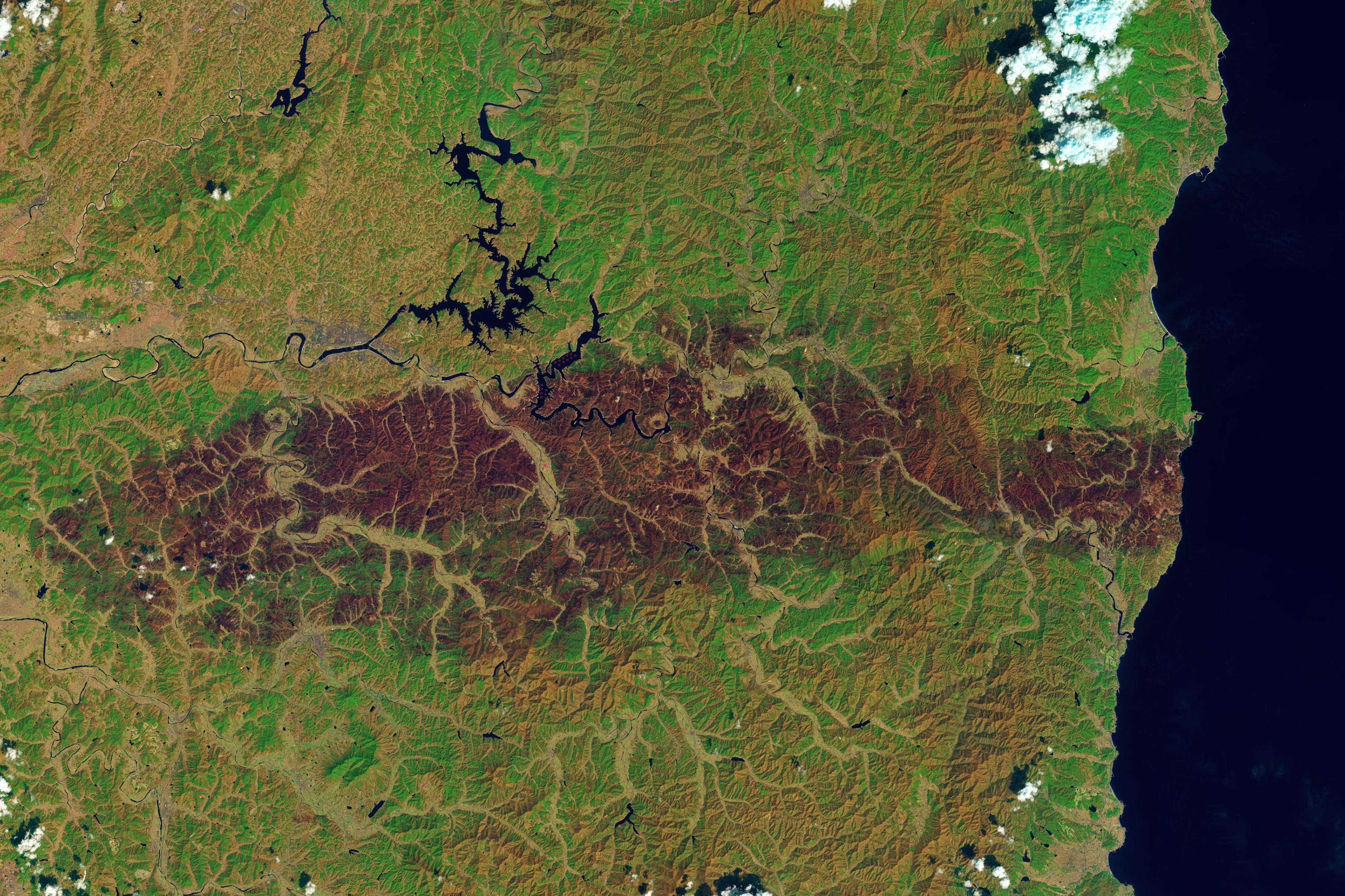
    Raging wildfires engulfed parts of South Korea in March 2025, leaving a trail of destruction visible from space.

    In March 2025, wildfires swept across South Korea, scorching vast swaths of land and prompting a massive emergency response.

    Fanned by dry, windy conditions, the blazes destroyed historic sites, leveled thousands of structures, and marked one of the nation’s worst fire disasters. Satellite images from Landsat 9 captured the burned landscape in stark detail, highlighting the scale of the damage.

    Wildfires Ravage South Korea in March 2025

    In March 2025, a series of destructive wildfires swept across parts of South Korea. Some of the largest fires, including those near Andong in the southeastern region, were brought under control by the end of the month, according to news reports. However, the blazes left a lasting impact on the landscape.

    A burn scar in Gyeongsangbuk-do (North Gyeongsang) province is visible in this image, captured on April 4, 2025, by the OLI-2 (Operational Land Imager-2) on Landsat 9. The image uses false color, combining shortwave infrared, near-infrared, and visible light (bands 6-5-3), which helps highlight the contrast between unburned vegetation (shown in green) and areas recently affected by fire (shown in brown). A detailed view of the image is provided below.

    South Korea Charred by Fire April 2025 Detail
    A detailed view from the satellite image acquired on April 4, 2025.

    Firestorms Fueled by Weather Extremes

    Dozens of blazes began to ignite across the country on March 21 amid dry, windy conditions. The next day, a particularly large plume of smoke was visible near Andong. This fire continued to spread, and by March 25, satellite-derived thermal anomalies indicated that the blaze reached all the way to the coast. Light rain moved over the area and helped officials contain the blaze by March 28. Smoke and clouds ultimately cleared, allowing Landsat 9 to observe a burned area stretching more than 80 kilometers (50 miles) from the coastline.

    Historic Losses Mark One of South Korea’s Worst Fire Events

    According to news reports, the deadly fires burned tens of thousands of hectares and destroyed thousands of structures, some of them historic. The incident has been described as being among the country’s worst fire disasters.

    NASA Earth Observatory images by Lauren Dauphin, using Landsat data from the U.S. Geological Survey. Story by Kathryn Hansen.

    Never miss a breakthrough: Join the SciTechDaily newsletter.
    Follow us on Google and Google News.

    Geography NASA NASA Earth Observatory
    Share. Facebook Twitter Pinterest LinkedIn Email Reddit

    Related Articles

    NASA Picturing Earth: Astronaut Photography In Focus [Video]

    Coloring the Great Salt Lake – Astronaut Takes Beautiful Photograph From Space Station

    Sea Ice in Denmark Strait – Drifted More Than 1,000 Km (600 Miles) From the Arctic Ocean

    NASA Scientists Map Beirut Blast Damage – Devastating Explosion Rocked Port Area

    NASA Advanced Rapid Imaging Satellite Maps Blast Damage: Beirut Explosion Aftermath

    NASA/NOAA Satellites Observe Surprisingly Rapid Increase in Scale and Intensity of Fires in Siberia

    Mars Terraforming: Cultivating Ideas for Mars on Earth

    Meandering Mississippi River: Photo Taken by Astronaut on Space Station Shows Divergence From State Boundaries

    Incredible Rare Peek at Patagonia in Winter

    Leave A Reply Cancel Reply

    • Facebook
    • Twitter
    • Pinterest
    • YouTube

    Don't Miss a Discovery

    Subscribe for the Latest in Science & Tech!

    Trending News

    Don’t Miss: A Brilliant Venus and Glowing Harvest Moon Light Up the Sky

    New Twist on the Einstein Problem Reveals Unexpected Physics

    JWST Captures Stunning Evidence of How Supermassive Black Holes Feed

    Early Exercise May Permanently Change How Much Energy the Body Uses To Move

    New Molecule Wipes Out Aggressive Lymphoma Tumors in Mice in Just 11 Days

    The Human Family Tree May Need a Major Rewrite

    Scientists Find a Surprising Cancer-Fighting Effect in Dark Sweet Cherries

    New AI Detects Hidden Warning Signs of Solar Eruptions Hours Before They Emerge

    Follow SciTechDaily
    • Facebook
    • Twitter
    • YouTube
    • Pinterest
    • Newsletter
    • RSS
    SciTech News
    • Biology News
    • Chemistry News
    • Earth News
    • Health News
    • Physics News
    • Science News
    • Space News
    • Technology News
    Recent Posts
    • Pomegranates Could Unlock a New Treatment for Heart Failure
    • Africa’s Giant Herbivores Were Disappearing Millions of Years Before Humans Could Hunt Them
    • This Utah Mountain Is Hiding Enough Ice To Fill 600 Olympic Pools
    • Vagus Nerve Stimulation Could Unlock the Brain’s Hidden Learning Potential
    • Your Mother’s Age May Leave a Biological Mark That Lasts for Generations
    Copyright © 1998 - 2026 SciTechDaily. All Rights Reserved.
    • Science News
    • About
    • Contact
    • Editorial Board
    • Privacy Policy
    • Terms of Use

    Type above and press Enter to search. Press Esc to cancel.