
Close Menu
    Facebook X (Twitter) Instagram
    SciTechDaily
    • Biology
    • Chemistry
    • Earth
    • Health
    • Physics
    • Science
    • Space
    • Technology
    Facebook X (Twitter) Pinterest YouTube RSS
    SciTechDaily
    Home»Earth»NASA Analyzes Tropical Storm Dorian Day and Night
    Earth

    NASA Analyzes Tropical Storm Dorian Day and Night

    By Rob Gutro, NASA’s Goddard Space Flight CenterAugust 27, 2019No Comments4 Mins Read
    Facebook Twitter Pinterest Telegram LinkedIn WhatsApp Email Reddit
    Share
    Facebook Twitter LinkedIn Pinterest Telegram Email Reddit
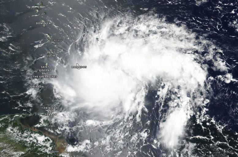
    Tropical Storm Dorian from NOAA Suomi NPP Satellite
    NASA-NOAA’s Suomi NPP satellite passed over the western North Atlantic Ocean and captured a visible image of Tropical Storm Dorian approaching the Leeward Islands on August 26, 2019. Credit: NASA Worldview, Earth Observing System Data and Information System (EOSDIS).

    The Leeward Islands are a group of islands in the eastern Caribbean Sea, where the sea meets the western Atlantic Ocean. The Leewards extend from the Virgin Islands east of Puerto Rico, southeast to Guadeloupe and its dependencies.

    The Visible Infrared Imaging Radiometer Suite (VIIRS) instrument aboard Suomi NPP provided a visible image of the storm on August 26, 2019. The VIIRS image showed the storm had taken on somewhat of a comma shape. That shape and the storm’s thunderstorm pattern changed over the course of the day because dry air moved into mid-level areas of the storm, suppressing thunderstorm development. A tropical cyclone is made up of hundreds of thunderstorms, so when development is inhibited, it affects the storm’s strength and sometimes the shape of the storm, depending on the direction from which the dry air comes.

    By 5 p.m. EDT on August 26, the National Hurricane Center said, “Although the inner-core convection has decreased recently, a recent burst of strong convection (rising air that forms thunderstorms) with cloud tops colder than minus 80 degrees Celsius [indicating powerful thunderstorms with the potential to generate heavy rainfall] has redeveloped just north of the low-level center.”
    Tropical Storm Dorian Night from NOAA Suomi NPP Satellite
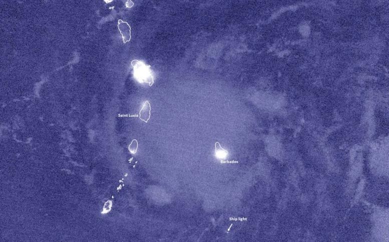
    At 1:06 a.m. EDT (0506 UTC) on August 27, the Suomi NPP satellite passed over Dorian again, and viewed the storm at night and obtained high resolution infrared-band imagery. The nighttime image showed that Dorian appeared to be relatively compact in size with a few overshooting cloud tops and some tropospheric convective gravity waves. Credit: NASA/NOAA/UWM-SSEC-CIMSS/William Straka III

    At 1:06 a.m. EDT (0506 UTC) on August 27, the Suomi NPP satellite passed over Dorian again, viewed the storm at night, and obtained high-resolution infrared-band imagery. The nighttime image showed that Dorian appeared to be relatively compact in size with a few overshooting cloud tops and some tropospheric convective gravity waves.

    The nighttime image was created by William Straka III, a researcher at the University of Wisconsin – Madison, Space Science and Engineering Center (SSEC Cooperative Institute for Meteorological Satellite Studies (CIMSS). “The Waning Crescent moon, with 12 percent illumination didn’t show many features,” Straka said. “Even with airglow present, though one could see the city lights peeking through the clouds and a lone ship on the southern edge of the storm.”

    By August 27, Dorian moved across St. Lucia and into the eastern Caribbean Sea bringing tropical storm-force winds with it. NHC said the Caribbean composite radar data show that Dorian remains a very compact system and that it still lacks a well-defined inner core.

    The National Hurricane Center or NHC posted many watches and warnings on August 27. A Hurricane Watch is in effect for Puerto Rico, the Dominican Republic from Isla Saona to Samana. A Tropical Storm Warning is in effect for Martinique, St. Vincent and the Grenadines, and Puerto Rico. A Tropical Storm Watch is in effect for Dominica, Grenada and its dependencies, Saba and St. Eustatius, the Dominican Republic from Isla Saona to Punta Palenque, and the Dominican Republic from Samana to Puerto Plata.

    At 8 a.m. EDT (1200 UTC) on Tuesday, August 27, NOAA’s National Hurricane Center or NHC noted the center of Tropical Storm Dorian was located by surface observations and Martinique radar data near latitude degrees 14.0 North and longitude 61.2 West. That puts the storm’s center just 15 miles (25 km) west-northwest of St. Lucia.

    Dorian is moving toward the west-northwest near 13 mph (20 kph), and this motion is expected to continue through tonight, followed by a turn toward the northwest on Wednesday.

    Maximum sustained winds are near 50 mph (85 kph) with higher gusts. Slow strengthening is forecast during the next 48 hours, and Dorian is forecast to be near hurricane strength when it moves close to Puerto Rico and eastern Hispaniola.

    NHC said, “On the forecast track, the center of Dorian will move across the eastern and northeastern Caribbean Sea during the next few days, passing near or south of Puerto Rico on Wednesday [August 28], move near or over eastern Hispaniola Wednesday night, and move north of Hispaniola on Thursday [August 29].”

    Never miss a breakthrough: Join the SciTechDaily newsletter.
    Follow us on Google and Google News.

    NASA NASA Goddard Space Flight Center NOAA
    Share. Facebook Twitter Pinterest LinkedIn Email Reddit

    Related Articles

    Massive Saharan Dust Aerosol Blanket Analyzed by NASA-NOAA Suomi NPP Satellite

    63 Mile Smoke Trail From Bighorn Fire Captured by NOAA/NASA Satellite

    Devastating Landslides Are Common in High Mountain Asia – Climate Change Could Trigger More

    Stunning Satellite Images As Rain Brings Relief to Australia’s Fires

    Satellite Imagery Shows Ferocious Fires in Australia Intensify

    Antarctic Ozone Hole Is the Smallest on Record Since Its Discovery [Video]

    NASA Satellite Image: Amazon Fires Shroud South America in Smoke

    NASA Study Reveals Multi-Year Ice Declining Faster than Perennial Ice that Surrounds It

    NASA’s GISS Releases Data Showing 2011 was Ninth-Warmest Year on Record

    Leave A Reply Cancel Reply

    • Facebook
    • Twitter
    • Pinterest
    • YouTube

    Don't Miss a Discovery

    Subscribe for the Latest in Science & Tech!

    Trending News

    JWST Finds a “Star” 100 Billion Times Brighter Than Any Star Should Be

    Scientists Find a Hidden Biological Link Across Different Forms of Autism

    Astronomers Discover a Ghostly River of Stars That Could Reveal Dark Matter

    Why Is Colorectal Cancer Rising in People Under 50? New Clues Point to the Environment

    Quantum Fluctuations Break a Crystal’s Symmetry Rules

    Why Does an Irregular Heartbeat Strike 40 Years Early in Some People?

    Scientists Reveal How ADHD Could Fuel Creative Thinking

    Scientists Find Just 3 Minutes of Sprinting Can Transform Blood Chemistry

    Follow SciTechDaily
    • Facebook
    • Twitter
    • YouTube
    • Pinterest
    • Newsletter
    • RSS
    SciTech News
    • Biology News
    • Chemistry News
    • Earth News
    • Health News
    • Physics News
    • Science News
    • Space News
    • Technology News
    Recent Posts
    • Hidden Brain Wiring May Help Preserve Thinking As Gray Matter Shrinks
    • Dual Stem Cell Treatment Restores Vision in First Human Trial
    • Your Waist Size May Reveal More About Your Health Than You Think
    • AI Decodes a Hidden DNA Signal Linked to Disease-Causing Mutations
    • Billions of Invasive Fish Have Taken Over the Great Lakes. Scientists Say We Can Still Stop Their Next Invasion
    Copyright © 1998 - 2026 SciTechDaily. All Rights Reserved.
    • Science News
    • About
    • Contact
    • Editorial Board
    • Privacy Policy
    • Terms of Use

    Type above and press Enter to search. Press Esc to cancel.