Close Menu
    Facebook X (Twitter) Instagram
    SciTechDaily
    • Biology
    • Chemistry
    • Earth
    • Health
    • Physics
    • Science
    • Space
    • Technology
    Facebook X (Twitter) Pinterest YouTube RSS
    SciTechDaily
    Home»Earth»63 Mile Smoke Trail From Bighorn Fire Captured by NOAA/NASA Satellite
    Earth

    63 Mile Smoke Trail From Bighorn Fire Captured by NOAA/NASA Satellite

    By NASA/Goddard Space Flight CenterJune 24, 20201 Comment3 Mins Read
    Facebook Twitter Pinterest Telegram LinkedIn WhatsApp Email Reddit
    Share
    Facebook Twitter LinkedIn Pinterest Telegram Email Reddit
    Bush Fire in Arizona
    Bighorn Fire on June 22, 2020. Credit: NASA Worldview, Earth Observing System Data and Information System (EOSDIS)

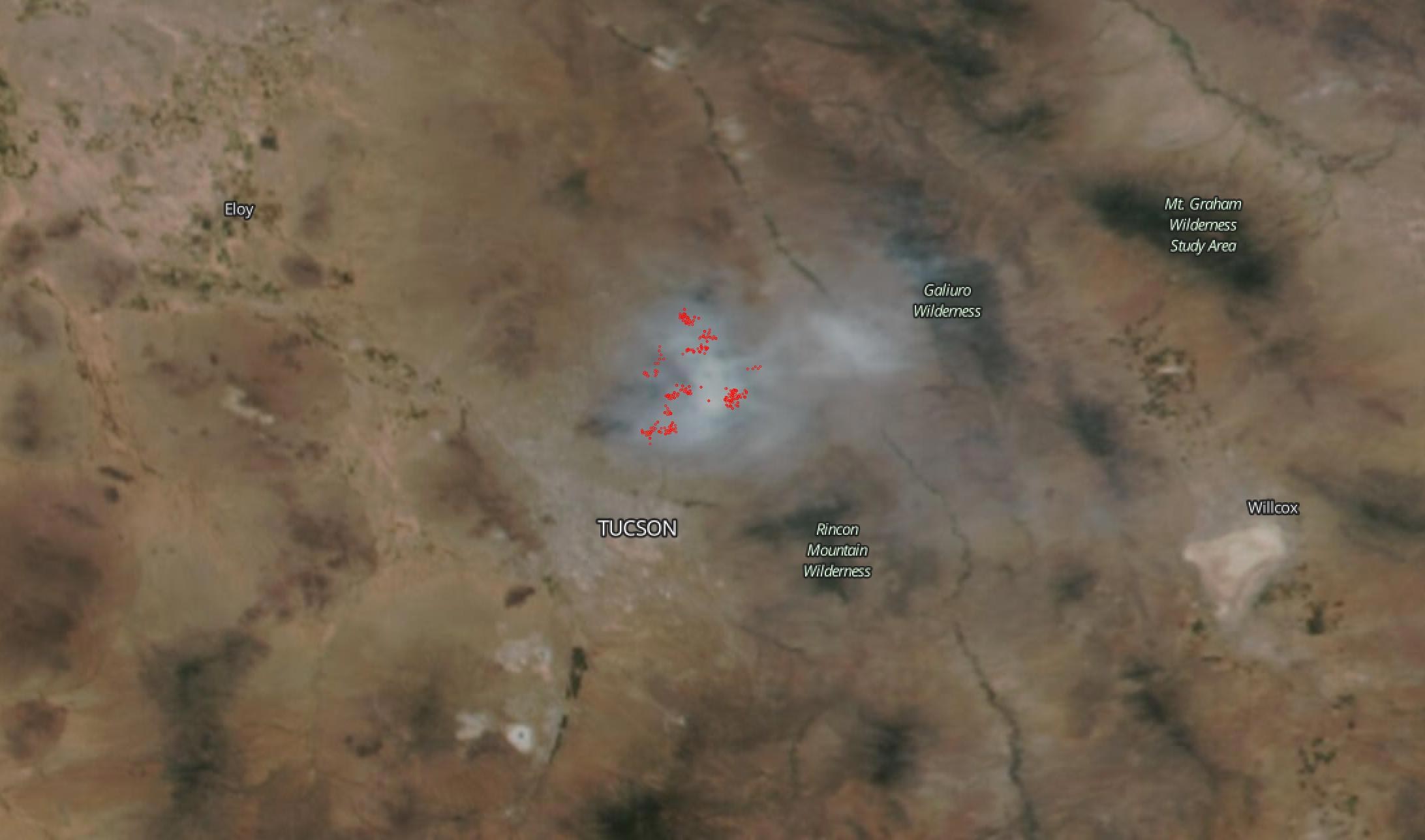
    NOAA/NASA’s Suomi NPP satellite captured this image of the Bighorn Fire on June 22, 2020, showing clouds of smoke pouring off this fire that is plaguing Arizona. On June 24, the fire has grown to 65,536 acres (102 square miles) and is 33 percent contained.  On June 05, 2020, a lightning strike started the Bighorn Fire in the Catalina Mountains northwest of Tucson, Arizona in the Coronado National Forest.  Due to current dry, windy weather conditions the fire has pushed closer to communities forcing evacuation.  Dry conditions also add to fuel stores of tinder-dry tall grass, brush, dormant brush, and hardwood slash.

    The fire is burning in steep and rugged terrain in the Pusch Ridge Wilderness. Catalina State Park and several popular trails in the area are closed including Romero Canyon, Pima Canyon, Finger Rock, Pontatoc, Pontatoc Ridge, and Linda Vista. Smoke impacts to surrounding communities are being carefully monitored.

    63 Mile Smoke Trail
    NOAA/NASAs Suomi NPP satellite image is overlaid with rulers from the Worldview program which shows how far the smoke has traveled from the Bighorn Fire. In the southeast direction it has traveled up to 63 miles and to the northeast it is traveled to 41 miles from the fire. Credit: NASA Worldview

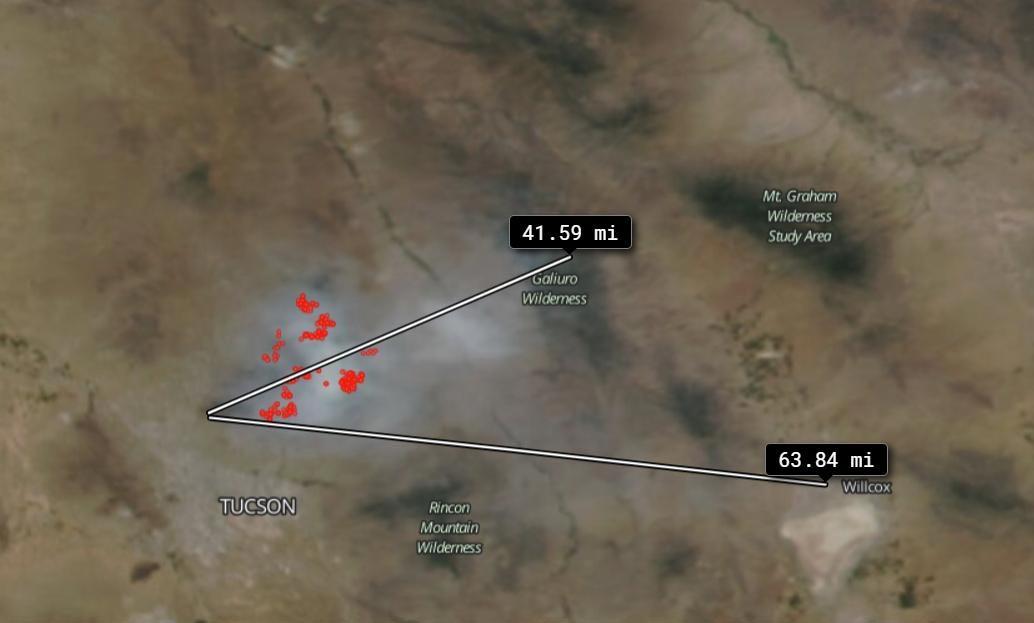
    The Suomi NPP image below illustrates the flow of the smoke from the Bighorn Fire which extends out 63 miles (101 kilometers) southeast and 41 miles (66 kilometers) to the northeast. The ruler is an application which is available through the Worldview website to measure distances.

    NASA’s satellite instruments are often the first to detect wildfires burning in remote regions, and the locations of new fires are sent directly to land managers worldwide within hours of the satellite overpass. Together, NASA instruments detect actively burning fires, track the transport of smoke from fires, provide information for fire management, and map the extent of changes to ecosystems, based on the extent and severity of burn scars. NASA has a fleet of Earth-observing instruments, many of which contribute to our understanding of fire in the Earth system. Satellites in orbit around the poles provide observations of the entire planet several times per day, whereas satellites in a geostationary orbit provide coarse-resolution imagery of fires, smoke, and clouds every five to 15 minutes.

    NASA’s Earth Observing System Data and Information System (EOSDIS) Worldview application provides the capability to interactively browse over 700 global, full-resolution satellite imagery layers and then download the underlying data. Many of the available imagery layers are updated within three hours of observation, essentially showing the entire Earth as it looks “right now.” Actively burning fires, detected by thermal bands, are shown as red points.

    Never miss a breakthrough: Join the SciTechDaily newsletter.
    Follow us on Google and Google News.

    NASA NASA Goddard Space Flight Center NOAA Wildfires
    Share. Facebook Twitter Pinterest LinkedIn Email Reddit

    Related Articles

    Devastating Landslides Are Common in High Mountain Asia – Climate Change Could Trigger More

    Latest NASA Satellite Observations of Australia’s Bushfires Show Smoke Going Round the World

    World Path of Smoke and Aerosols From Australian Fires Animated by Fleet of NASA Satellites

    Satellite View of Australian Fires Shows Severe Burn Scars Across Kangaroo Island

    Stunning Satellite Images As Rain Brings Relief to Australia’s Fires

    Satellite Imagery Shows Ferocious Fires in Australia Intensify

    Antarctic Ozone Hole Is the Smallest on Record Since Its Discovery [Video]

    NASA Analyzes Tropical Storm Dorian Day and Night

    NASA Satellite Image: Amazon Fires Shroud South America in Smoke

    1 Comment

    1. Robert Privette on June 25, 2020 9:00 am

      Can you display the (abpve) fire pictures with a wind overlay showing direction and speed?
      Also, rain clouds location would be helpful. Thanks for the pics. rlp

      Reply
    Leave A Reply Cancel Reply

    • Facebook
    • Twitter
    • Pinterest
    • YouTube

    Don't Miss a Discovery

    Subscribe for the Latest in Science & Tech!

    Trending News

    Scientists Discover Stem Cells That Could Regrow Teeth and Bone

    Early Cannabis Use May Stall Key Brain Skills in Teens

    Popular Vitamin D Supplement Has “Previously Unknown” Negative Effect, Study Finds

    Study Reveals Malaria’s Hidden Role in Human Evolution

    The Hidden Risk of Taking Breaks From Weight-Loss Drugs Like Ozempic

    Scientists Warn That This Common Pet Fish Can Wreck Entire Ecosystems

    Scientists Make Breakthrough in Turning Plastic Trash Into Clean Fuel Using Sunlight

    This Popular Supplement May Interfere With Cancer Treatment, Scientists Warn

    Follow SciTechDaily
    • Facebook
    • Twitter
    • YouTube
    • Pinterest
    • Newsletter
    • RSS
    SciTech News
    • Biology News
    • Chemistry News
    • Earth News
    • Health News
    • Physics News
    • Science News
    • Space News
    • Technology News
    Recent Posts
    • Beyond Inflammation: Scientists Uncover New Cause of Persistent Rheumatoid Arthritis
    • Cancer-Like Mutations Found in the Brain May Be Driving Alzheimer’s Disease
    • A Simple Molecule Could Unlock Safer, Easier Weight Loss
    • Stretching Diamonds Unlocks Powerful New Quantum Sensing Abilities
    • This Robot Could Explore Mars 3x Faster Than Today’s Rovers
    Copyright © 1998 - 2026 SciTechDaily. All Rights Reserved.
    • Science News
    • About
    • Contact
    • Editorial Board
    • Privacy Policy
    • Terms of Use

    Type above and press Enter to search. Press Esc to cancel.