
Close Menu
    Facebook X (Twitter) Instagram
    SciTechDaily
    • Biology
    • Chemistry
    • Earth
    • Health
    • Physics
    • Science
    • Space
    • Technology
    Facebook X (Twitter) Pinterest YouTube RSS
    SciTechDaily
    Home»Earth»Deforestation in Bolivia Spied From Space Satellite
    Earth

    Deforestation in Bolivia Spied From Space Satellite

    By ESA (European Space Agency)January 24, 2020No Comments3 Mins Read
    Facebook Twitter Pinterest Telegram LinkedIn WhatsApp Email Reddit
    Share
    Facebook Twitter LinkedIn Pinterest Telegram Email Reddit
    Deforestation in Bolivia
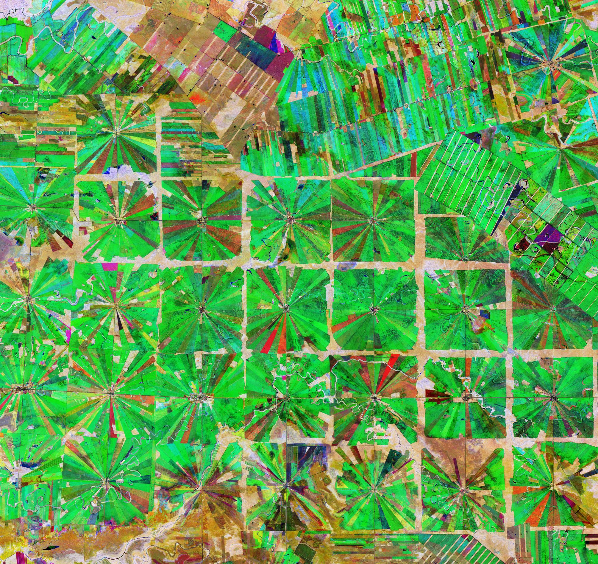
    This composite image was created by combing three separate ‘Normalized Difference Vegetation Index’ images from the Copernicus Sentinel-2 mission. The first image, from April 8, 2019, is visible in red; the second from June 22, 2019, can be seen in green; and the third from September 5, 2019 can be seen in blue. The Normalised Difference Vegetation Index is widely used in remote sensing as it gives scientists an accurate measure of healthy and status of plant growth. Credit: Contains modified Copernicus Sentinel data (2019), processed by ESA, CC BY-SA 3.0 IGO

    This Copernicus Sentinel-2 image features an area in the Santa Cruz Department of Bolivia, where part of the tropical dry forest has been cleared for agricultural use.

    Since the 1980s, the area has been rapidly deforested owing to a large agricultural development effort where people from the Andean high plains (the Altiplano region) have been relocated to the lowlands of Bolivia.

    The relatively flat lowlands and abundant rainfall make this region suitable for farming. In fact, the local climate allows farmers to benefit from two growing seasons. The region has been transformed from a dense forest into a patterned expanse of agricultural land. This deforestation method, common in this part of Bolivia, is characterized by the radial patterns that can be seen clearly in the image.

    Each patterned field is approximately 20 sq km and each side is around 2.5 km long.

    Small settlements can be seen in the center of each individual field in the image, which typically contains a church, a school, and a soccer field. These communities are joined by a road network depicted by the straight lines that bisect the radial fields and connect the adjacent areas.

    Meandering streams and rivers can be seen flowing through the fields. The long, thin strips of land in the top right of the image are most likely cultivated soybean fields.

    Rainforests worldwide are being destroyed at an alarming rate. This is of great concern as they play an important role in global climate, and are home to a wide variety of plants and animals.

    Because of their unique perspective from space, Earth observation satellites are instrumental in providing comprehensive information on the full extent and rate of deforestation, which is particularly useful for monitoring remote areas.

    This composite image was created by combing three separate ‘Normalized Difference Vegetation Index’ images from the Copernicus Sentinel-2 mission. The first image, from April 8, 2019, is visible in red; the second from June 22, 2019, can be seen in green; and the third from September 5, 2019, can be seen in blue. The Normalised Difference Vegetation Index is widely used in remote sensing as it gives scientists an accurate measure of the health and status of plant growth.

    Never miss a breakthrough: Join the SciTechDaily newsletter.
    Follow us on Google and Google News.

    Agriculture Deforestation Ecology European Space Agency Geography
    Share. Facebook Twitter Pinterest LinkedIn Email Reddit

    Related Articles

    Agricultural Research Shows Global Cropland Could Almost Be Cut in Half

    Mysterious Red Circles in Satellite Image of Southern Ukraine Explained

    Earth From Space: Lake George, Uganda – A Center for Biological Diversity [Video]

    Earth From Space: Japanese Archipelago [Video]

    Earth From Space: Faroe Islands [Video]

    Earth From Space: Tromsø, Norway [Video]

    Deforestation Adds More Atmospheric CO2 Than the Sum Total of Cars & Trucks on the World’s Roads

    Survey of Brazil’s Atlantic Forests Reveals Loss of Key Species

    Preserving Biodiversity When Agricultural Production Increases

    Leave A Reply Cancel Reply

    • Facebook
    • Twitter
    • Pinterest
    • YouTube

    Don't Miss a Discovery

    Subscribe for the Latest in Science & Tech!

    Trending News

    Scientists Say Love Follows Mathematical Patterns

    “Zombie Cells” Reveal a Hidden Weakness That Could Help Fight Aging

    Alien Signals May Be Hiding in a Radio Band SETI Has Barely Explored

    Earth’s Hidden Thermostat Has Regulated Climate for 60 Million Years

    This 518-Million-Year-Old Creature Reveals How Spiders Got Their Bite

    Scientists Built a Programmable Chip That Can Slow Light on Command

    The Backyard “Silly Sprinkler” That Cracked One of Physics’ Biggest Puzzles

    This Common Sleep Habit Could Be Making You Gain Weight

    Follow SciTechDaily
    • Facebook
    • Twitter
    • YouTube
    • Pinterest
    • Newsletter
    • RSS
    SciTech News
    • Biology News
    • Chemistry News
    • Earth News
    • Health News
    • Physics News
    • Science News
    • Space News
    • Technology News
    Recent Posts
    • How Brown Tree Snakes Became an Unstoppable Invasive Species
    • Scientists Discover the Brain Is Not Always Ready To Make Memories
    • Earth’s First Complex Organisms May Hold Clues to Life Beyond Our Planet
    • Dark Matter’s Secret Force Could Reshape Our Understanding of the Universe
    • This Star Is Racing Around the Milky Way’s Black Hole at 8% the Speed of Light
    Copyright © 1998 - 2026 SciTechDaily. All Rights Reserved.
    • Science News
    • About
    • Contact
    • Editorial Board
    • Privacy Policy
    • Terms of Use

    Type above and press Enter to search. Press Esc to cancel.