Close Menu
    Facebook X (Twitter) Instagram
    SciTechDaily
    • Biology
    • Chemistry
    • Earth
    • Health
    • Physics
    • Science
    • Space
    • Technology
    Facebook X (Twitter) Pinterest YouTube RSS
    SciTechDaily
    Home»Earth»Mysterious Red Circles in Satellite Image of Southern Ukraine Explained
    Earth

    Mysterious Red Circles in Satellite Image of Southern Ukraine Explained

    By European Space Agency (ESA)May 11, 20202 Comments2 Mins Read
    Facebook Twitter Pinterest Telegram LinkedIn WhatsApp Email Reddit
    Share
    Facebook Twitter LinkedIn Pinterest Telegram Email Reddit
    Southern Ukraine From Space
    This image of Southern Ukraine taken on June 26, 2019, shows a patchwork of agricultural fields dominated by winter wheat, spring barley, and corn. The near-infrared channel was used to make vegetation appear bright red. Credit: ESA, CC BY-SA 3.0 IGO

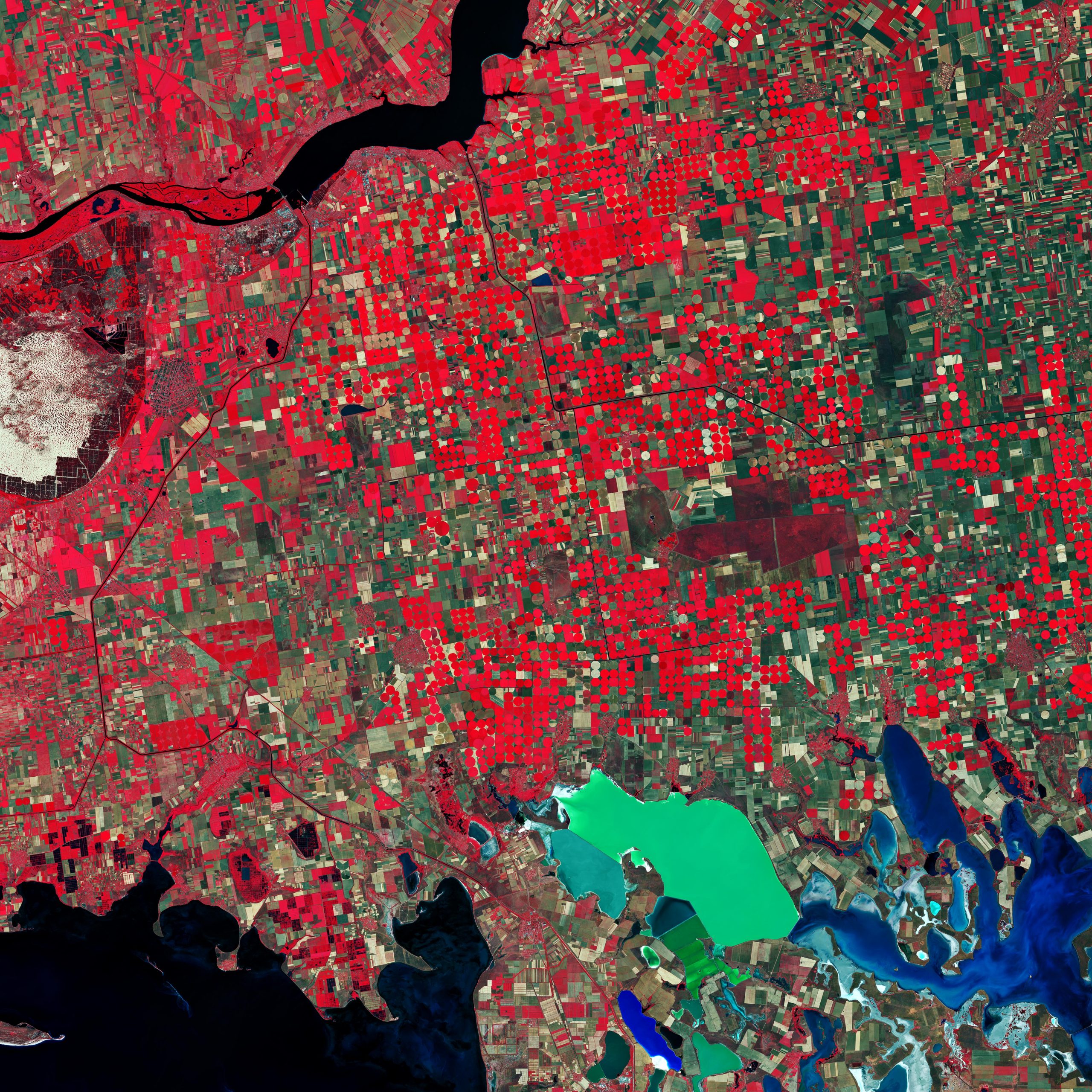
    Southern Ukraine is featured in this false-color image captured by the Copernicus Sentinel-2 mission. This image was processed in a way that included the near-infrared channel, which makes vegetation appear bright red.

    Owing to Ukraine’s climate and arable land, agriculture plays a large role in the country’s economy. In this image, captured on June 26, 2019, a patchwork of agricultural fields dominate the landscape. Ukraine’s main grain crops are winter wheat, spring barley, and corn.

    Circular shapes in the image are an example of center-pivot irrigation systems, where equipment rotates around a central pivot, and crops are watered with sprinklers.

    The bright red contrasts with the black waters of the Kakhovka Reservoir on the Dnieper River, visible at the top of the image. Canals are visible as thin, black lines cutting through the agricultural fields, and are mostly used for water supply and irrigation of the surrounding farmlands.

    In the far left of the image, the oval-shaped Oleshky Sands is visible. Covering an area of around 160 sq km (390 sq mi)., this large expanse of sand is considered a small desert in Ukraine. The grassy plains that used to cover the area are said to have died off hundreds of years ago owing to sheep farming – initiating the area’s desertification.

    In the bottom-right of the image, a colorful network of salty lagoons lie along the northern border of the Crimean Peninsula. These shallow, marshy inlets are known as Syvash (also Sivash or Sivaš). During summer months, the warmer marsh waters leave unpleasant odors – earning the region the nicknames ‘Putrid Sea’ and ‘Rotten Sea.’

    Copernicus Sentinel-2 is a two-satellite mission. Each satellite carries a high-resolution camera that images Earth’s surface in 13 spectral bands. The mission is mostly used to track changes in the way land is being used and to monitor the health of our vegetation.

    Image: Contains modified Copernicus Sentinel data (2019), processed by ESA, CC BY-SA 3.0 IGO

    Never miss a breakthrough: Join the SciTechDaily newsletter.
    Follow us on Google and Google News.

    Agriculture European Space Agency Geography Geology
    Share. Facebook Twitter Pinterest LinkedIn Email Reddit

    Related Articles

    Salt and Spectacle: Satellite Reveals East Africa’s Pink Lakes

    Exploring Earth From Space: Maharloo Lake, Iran [Video]

    More Than One-Third of Corn Belt Farmland Has Completely Lost Its Carbon-Rich Topsoil

    Vast Mineral Deposits in the Atacama Desert Seen From Space

    Earth From Space: Magnificent Canadian Arctic Archipelago

    Earth From Space: Bolivian Highland Heart [Video]

    Deforestation in Bolivia Spied From Space Satellite

    Earth From Space: Tromsø, Norway [Video]

    Search for Extra-Terrestrial Life Takes Mars Scientists on Expedition to Australia

    2 Comments

    1. Willard Bascomb on May 15, 2020 6:40 pm

      DUH !
      First time at SciTech.
      Fake Science, No Interest.
      Disappointed.

      Willard.

      Reply
    2. William on May 16, 2020 6:46 am

      More like schit-tech than SciTech. What crud! Next we’ll be taught about the mysterious liquid filling the depression between Africa and South America.

      Reply
    Leave A Reply Cancel Reply

    • Facebook
    • Twitter
    • Pinterest
    • YouTube

    Don't Miss a Discovery

    Subscribe for the Latest in Science & Tech!

    Trending News

    Scientists Warn: America’s Most Popular Cooking Oil May Be Harming Your Intestines

    Scientists Say a 59,000-Year-Old Neanderthal Tooth Shows Evidence of Surgery

    Scientists Finally Think They Know Why T. rex Had Tiny Arms

    This Alien Planet Has Rock Clouds That Vaporize Before Sunset

    The Simple Habit That Could Lower Your Cancer Risk

    146,000-Year-Old Discovery Rewrites the Story of Human Creativity

    The Type of Alcohol You Drink Could Affect How Long You Live

    This Common Vitamin May Help Stop Prediabetes From Turning Into Diabetes

    Follow SciTechDaily
    • Facebook
    • Twitter
    • YouTube
    • Pinterest
    • Newsletter
    • RSS
    SciTech News
    • Biology News
    • Chemistry News
    • Earth News
    • Health News
    • Physics News
    • Science News
    • Space News
    • Technology News
    Recent Posts
    • Scientists Discover How Obesity May Trigger Alzheimer’s Disease
    • Scientists Confirm Alcohol Causes Widespread Health Damage
    • Researchers Discover Cannabis Compounds That May Fight Obesity Without the High
    • It Took 40 Years for Technology To Catch Up to This Revolutionary Zipper Design
    • NASA’s Psyche Spacecraft Just Used Mars as a Giant Slingshot
    Copyright © 1998 - 2026 SciTechDaily. All Rights Reserved.
    • Science News
    • About
    • Contact
    • Editorial Board
    • Privacy Policy
    • Terms of Use

    Type above and press Enter to search. Press Esc to cancel.