A satellite-based analysis indicates that nearly 27 million tons of wheat were harvested from Ukraine’s farms this year, but the country won’t reap all of the benefits.
Russia’s further invasion of Ukraine in February 2022 fueled widespread concern about the effects on the country’s farming sector. In the early days of the crisis, food security specialists wondered if Ukrainian farmers would be able to harvest the wheat and barley they had planted the previous fall. They also worried that declining grain exports from Ukraine might throw global markets into turmoil and trigger food shortages continents away.
“Now we are starting to get answers,” said Inbal Becker-Reshef, director of the NASA Harvest program. “Our satellite-based production numbers for the 2022 winter wheat crop in Ukraine make clear that farmers had a largely successful harvest.”
Winter Wheat Harvest in 2022: Surprising Results
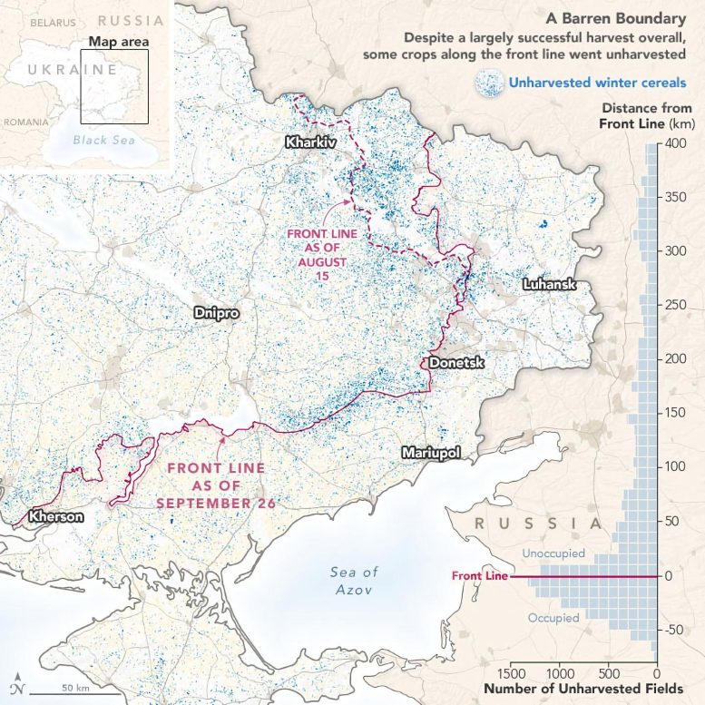
The NASA Harvest team calculated that farmers harvested 26.6 million tons of wheat in 2022, several million tons higher than expected in leading forecasts. “That’s down from the previous year’s record harvest of 33 million tons, but it’s close to the five-year average of 27.9 million tons,” Becker-Reshef added. However, Ukraine does not have access to 22 percent of that wheat in the eastern part of the country due to the war.
The map at the top of the page, based on NASA Harvest data, shows the distribution of unharvested wheat in late August 2022. Data showing the location of the front line comes from the Institute for the Study of War and the American Enterprise Institute’s Critical Threats Project.
“The risks on the ground during the war have made the NASA Harvest monitoring system one of the only safe and reliable ways for researchers to track what is happening to crops in Ukraine,” said Sergii Skakun, a NASA Harvest and Land-Cover and Land-Use Change scientist who spent multiple years at Ukraine’s Space Research Institute. The system combines satellite observations and modeling to assess the planting, growth, and harvest of key commodity crops. Data come from the commercial satellite company Planet, NASA, and the European Space Agency. NASA researchers have been working together for more than a decade with colleagues from the Ministry of Agrarian Policy and Food of Ukraine, the University of Maryland, the University of Strasbourg, the Group on Earth Observations Global Agricultural Monitoring Initiative (GEOGLAM), ESA World Cereals, National Technical University of Ukraine “Igor Sikorsky Kyiv Polytechnic Institute,” and several other organizations.
Ukrainian officials also monitored the harvest from the ground to the extent possible. “The actual data we are gradually receiving directly from the fields in the territories controlled by Ukraine are very close to the estimates obtained in cooperation with NASA,” said Denys Palamarchuk of the Ministry of Agrarian Policy and Food of Ukraine.
Harvest Challenges and Economic Implications
At the outset of Russia’s full-scale invasion in February, some analysts cautioned that 20 to 30 percent of Ukraine’s winter crops might not be harvested at the end of the summer. However, NASA Harvest’s analysis indicates that 94 percent of the winter crop was harvested, including 88 percent of winter crops in areas not controlled by Ukraine, according to Abdolreza Abbassian, a NASA Harvest partner and former secretary to the G-20 Agricultural Market Information System (AMIS).
Due to a United Nations-brokered trade initiative that alleviated blockages at a few Black Sea ports, some of that Ukrainian grain made its way into global markets. About 5.4 million tons of wheat has been shipped from Ukraine since the beginning of the war, according to data published by the Ukraine Ministry of Agrarian Policy and Food in November 2022.
However, Russia will likely reap the benefit of a significant portion of the close to 27-million-ton wheat crop, said Skakun. The analysis showed that 5.8 million tons of wheat was harvested from areas that were not under Ukrainian control. That represents a loss of at least $1 billion, Abbassian noted.
Unharvested Wheat and Satellite Imagery Insights
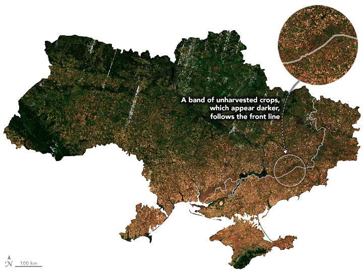
The NASA Harvest team used satellites to observe the areas that were left unharvested and found they were mainly concentrated along the front line. Wheat is largely harvested in mid-July. In the natural-color mosaic above, based on imagery from Planet, unharvested wheat fields (dark brown) stand out compared to the harvested (light brown) fields to the north and south. The lighter brown color is a sign of leftover plant debris covering the fields after harvesting equipment has sheared the wheat and separated the valuable parts. The image is a biweekly composite, based on PlanetScope imagery collected between July 12-26, 2022, by Dove satellites.
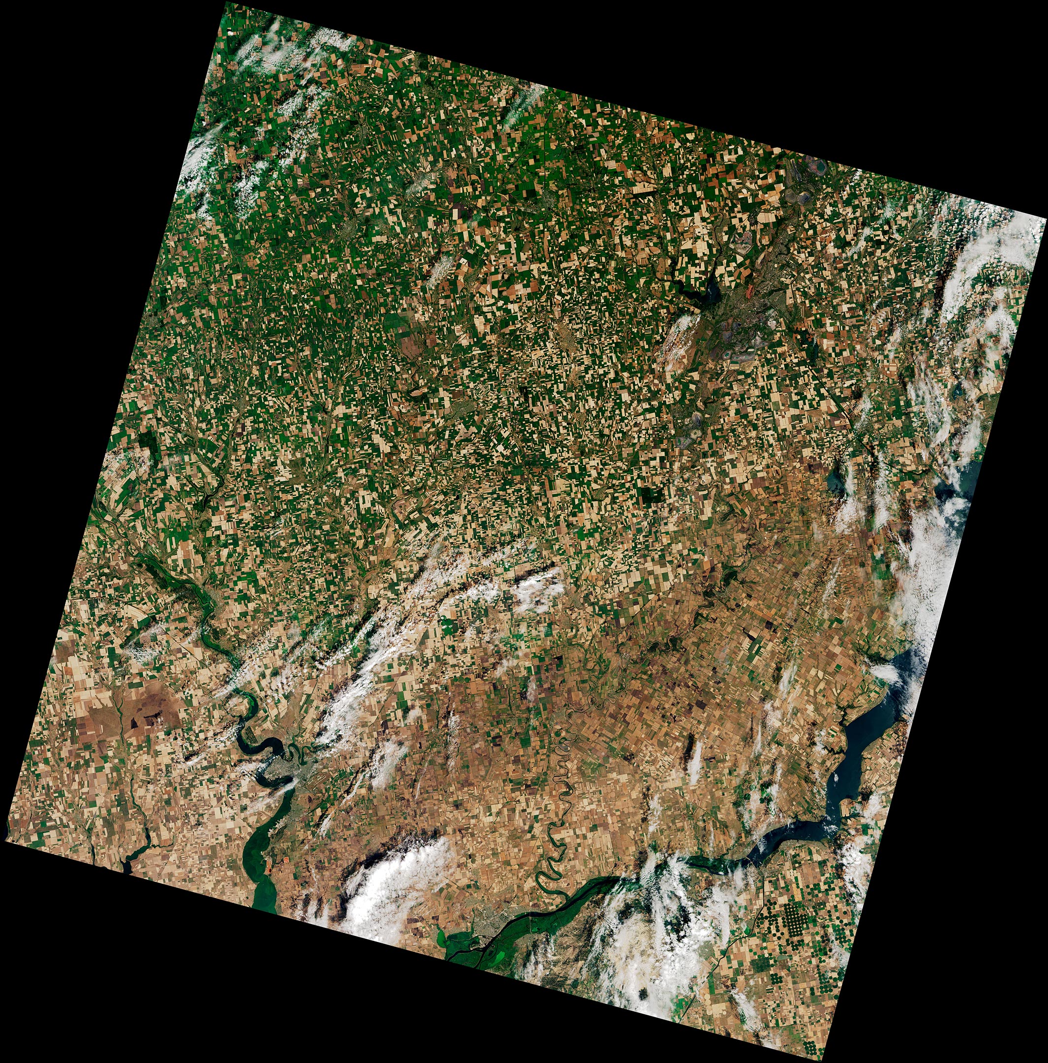
The detailed image above shows unharvested wheat around the villages of Lepetykha and Fedorivka compared to harvested wheat around Velyka Oleksandrivka. The natural-color image was acquired by the Operational Land Imager (OLI) on Landsat 8. OLI views fields at 30 meters per pixel, meaning each pixel represents an area about the size of a baseball infield.
Planet, a commercial satellite company that has an agreement to provide data to NASA, delivered images with 3 meter-per-pixel resolution, providing even more detail. “Whether blunting the sharpest impacts of genuine shortages, or helping everyone see the reality of improved production, better information can help us reduce human suffering,” said Andrew Zolli, Planet’s chief impact officer.
Global Wheat Market Stability and Ongoing Food Crisis
Slackening global demand for wheat and increased supplies helped stabilize global wheat prices over the summer, explained NASA Harvest advisor and senior research fellow at the International Food Policy Research Institute (IFPRI) Joseph Glauber. “But this doesn’t mean the food crisis is over,” he said. “International food prices remain high by historical standards, markets remain tight, and high price volatility continues—especially for wheat.”
“Satellite data enables us to provide rapid agricultural assessments that are critical for markets and food security,” Becker-Reshef said. “Knowing the actual level of production in Ukraine contributes to lowered uncertainty and price volatility in food markets. This is a growing focus for the Harvest team, and we’re working on developing and launching a new agricultural rapid response center that will focus on that.”
NASA Earth Observatory images by Joshua Stevens, using data courtesy of Inbal Becker-Reshef, Josef Wagner, Shabarinath Nair, and Yuval Sadeh (NASA Harvest/University of Maryland/University of Strasbourg), PlanetScope data from Planet, and Landsat data from the U.S. Geological Survey. The NASA Harvest Ukraine analysis was produced by I. Becker-Reshef, J. Wagner, S. Nair, Y. Sadeh, S. Baber, M. Hosseini, S. Khabbazan, B. Barker, E. Duncan, F. Li, B. Munshell, M. Humber, R. Sahajpal, N. Kalecinski, and S. Skakun at the University of Maryland and the University of Strasbourg based on PlanetScope data from Planet and Copernicus Sentinel data. Institute for the Study of War and AEI’s Critical Threats Project provided the war zone boundaries and the ESA WorldCereal project provided cropland bounds for 2021. Story by Mary Mitkish and Adam Voiland.
Never miss a breakthrough: Join the SciTechDaily newsletter.
Follow us on Google and Google News.