
Close Menu
    Facebook X (Twitter) Instagram
    SciTechDaily
    • Biology
    • Chemistry
    • Earth
    • Health
    • Physics
    • Science
    • Space
    • Technology
    Facebook X (Twitter) Pinterest YouTube RSS
    SciTechDaily
    Home»Earth»Flevoland, Netherlands From Space: One of the Largest Land Reclamation Projects in the World
    Earth

    Flevoland, Netherlands From Space: One of the Largest Land Reclamation Projects in the World

    By European Space Agency (ESA)February 7, 2020No Comments3 Mins Read
    Facebook Twitter Pinterest Telegram LinkedIn WhatsApp Email Reddit
    Share
    Facebook Twitter LinkedIn Pinterest Telegram Email Reddit
    Flevoland Netherlands From Space
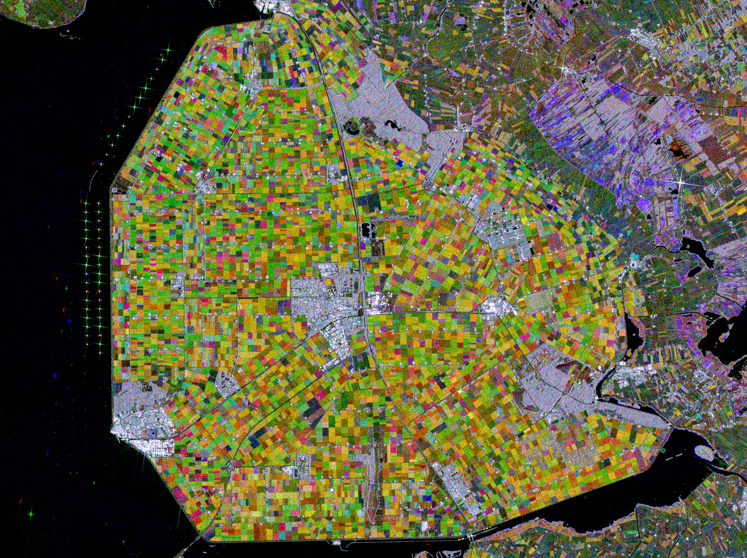
    This image combines three radar acquisitions from the Copernicus Sentinel-1 mission taken about two months apart to show change in crop and land conditions over time. The first image from May 8, 2018 is associated with red, the second from July 7 depicts changes in green, and the third from September 5 has been linked to blue. Credit: Contains modified Copernicus Sentinel data (2018), processed by ESA

    The Copernicus Sentinel-1 mission takes us over part of the Dutch province of Flevoland – the newest province in the Netherlands and one of the largest land reclamation projects in the world.

    With almost a third of the country lying below sea level, the Netherlands is famously known as a ‘low country,’ and has a long history of land reclamation.

    One reclamation project resulted in Flevoland. After a major flood it was decided to tame the Zuiderzee, a large, shallow inlet of the North Sea, to improve flood protection and also create additional land for agricultural use.


    In this week’s edition of the Earth from Space program, the Copernicus Sentinel-1 mission takes us over part of the Dutch province of Flevoland – the newest province in the Netherlands and one of the largest land reclamation projects in the world.

    The project entailed the creation of land known as polders. The ‘Noordoostpolder,’ or the Northeast polder is the focus of this image. Over the years, the region has developed to become a home to a modern and innovative agricultural industry. The province produces predominantly apples, cereals, potatoes and flowers – with each colorful patch in the image representing a different crop.

    This image combines three radar acquisitions from the Copernicus Sentinel-1 mission taken about two months apart to show change in crop and land conditions over time. The first image from May 8, 2018 is associated with red, the second from July 7 depicts changes in green, and the third from September 5 has been linked to blue.

    Along the dikes of the Ijsselmeer, west of the Noordoostpolder, lies one of the largest wind farms in the Netherlands. The strong, almost star-shaped, reflections that can be seen near the shore are around 86 wind turbines. The wind farm is said to generate approximately 1.4 billion kWh of clean renewable energy per year – comparable to the power consumption of over 400 000 households.

    Images acquired with radar are interpreted by studying the intensity of the backscatter radar signal, which is related to the roughness of the ground. Cities and towns are visible in white owing to the stronger reflection of the signal. Emmeloord can be seen in the center of the Noordoostpolder, as well as several farms that appear as bright white dots along the roads.

    Never miss a breakthrough: Join the SciTechDaily newsletter.
    Follow us on Google and Google News.

    European Space Agency Geography
    Share. Facebook Twitter Pinterest LinkedIn Email Reddit

    Related Articles

    Earth From Space: Magnificent Canadian Arctic Archipelago

    Breathtaking View of Andros, Bahamas From Space [Video]

    Stunning Views of Houston Texas From Copernicus Sentinel-1 Satellite

    Earth From Space: Bolivian Highland Heart [Video]

    Earth From Space: Lake George, Uganda – A Center for Biological Diversity [Video]

    Deforestation in Bolivia Spied From Space Satellite

    Earth From Space: Japanese Archipelago [Video]

    Earth From Space: Faroe Islands [Video]

    Earth From Space: Tromsø, Norway [Video]

    Leave A Reply Cancel Reply

    • Facebook
    • Twitter
    • Pinterest
    • YouTube

    Don't Miss a Discovery

    Subscribe for the Latest in Science & Tech!

    Trending News

    Don’t Miss: A Brilliant Venus and Glowing Harvest Moon Light Up the Sky

    New Twist on the Einstein Problem Reveals Unexpected Physics

    JWST Captures Stunning Evidence of How Supermassive Black Holes Feed

    Early Exercise May Permanently Change How Much Energy the Body Uses To Move

    New Molecule Wipes Out Aggressive Lymphoma Tumors in Mice in Just 11 Days

    The Human Family Tree May Need a Major Rewrite

    Scientists Find a Surprising Cancer-Fighting Effect in Dark Sweet Cherries

    New AI Detects Hidden Warning Signs of Solar Eruptions Hours Before They Emerge

    Follow SciTechDaily
    • Facebook
    • Twitter
    • YouTube
    • Pinterest
    • Newsletter
    • RSS
    SciTech News
    • Biology News
    • Chemistry News
    • Earth News
    • Health News
    • Physics News
    • Science News
    • Space News
    • Technology News
    Recent Posts
    • Scientists May Have Finally Explained Why Astronauts Get Constipated in Space
    • Pomegranates Could Unlock a New Treatment for Heart Failure
    • Africa’s Giant Herbivores Were Disappearing Millions of Years Before Humans Could Hunt Them
    • This Utah Mountain Is Hiding Enough Ice To Fill 600 Olympic Pools
    • Vagus Nerve Stimulation Could Unlock the Brain’s Hidden Learning Potential
    Copyright © 1998 - 2026 SciTechDaily. All Rights Reserved.
    • Science News
    • About
    • Contact
    • Editorial Board
    • Privacy Policy
    • Terms of Use

    Type above and press Enter to search. Press Esc to cancel.