
Once the world’s largest iceberg, A-68A has fractured into several smaller bergs as it drifts away from South Georgia.
Satellite images have revealed that the once colossal A-68A iceberg has had yet another shattering experience. Several large cracks were spotted in the berg last week and it has since broken into multiple pieces. These little icebergs could indicate the end of A-68A’s environmental threat to South Georgia.
One of the largest icebergs of all time, A-68A broke off from the Larsen-C ice shelf in 2017 and has been closely monitored over recent months as it veered dangerously close to South Georgia in the South Atlantic.

The iceberg’s close position to the remote island prompted fears that it would anchor itself to the coast and impact the fragile ecosystem that thrives around the island, through the scraping of the seabed or the release of cold freshwater into the surrounding ocean.
In December 2020, the iceberg changed direction, as ocean surface currents steered by sea floor bathymetry, diverted it in a southeast direction away from the island, losing a huge chunk of ice in the process.
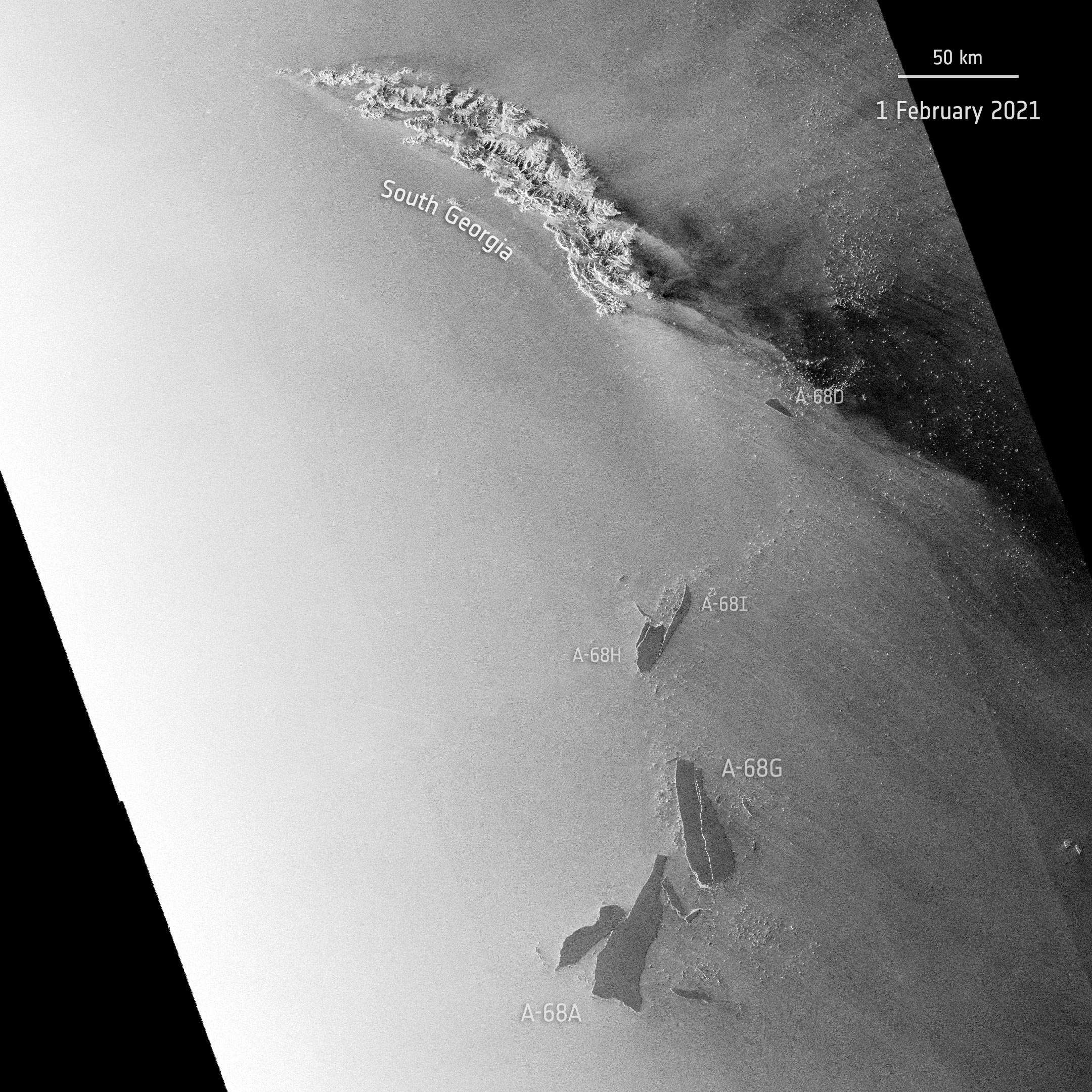
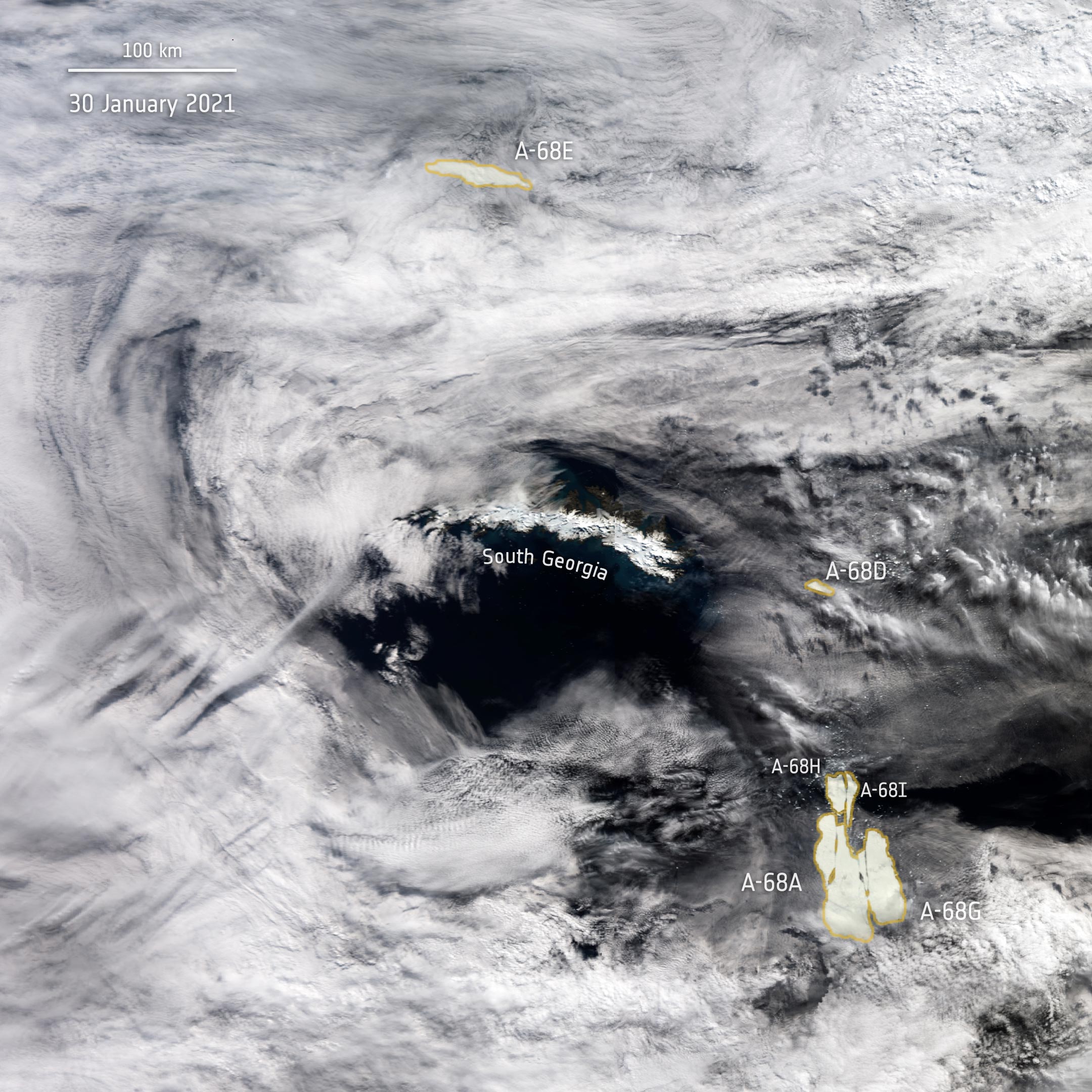
Images, captured by the Copernicus fleet of satellites have charted the process of A-68A on its journey over the course of the past three years. The latest data coming from the Copernicus Sentinel-1 radar mission shows the iceberg suffered further damage in 2021 as a new iceberg calved from A-68A just last week. The smaller slab, promptly named A-68G by the US National Ice Center, measures approximately 53 km (33 mi) in length and around 18 km (11.2 mi) at its widest point.
Soon after, a large crack developed where A-68G broke free, resulting in the almost-immediate calving of an additional two icebergs: A-68H (around 20 km or 12 mi in length and 9 km or 5.6 mi width) and A-68I (around 30 km or 18.6 mi long and 5 km or 3 mi width at its widest point). Antarctic icebergs are named from the Antarctic quadrant in which they were originally sighted, then a sequential number, then, if the iceberg breaks, a sequential letter.
The main A-68A iceberg, once the world’s largest, now measures only around 60 km (37 mi) in length with a maximum width of 22 km (13.7 mi). The collective group of icebergs appear to be drifting apart, with the A-68H moving northwards, approximately 130 km (81 mi) from South Georgia. As of today, the main A-68A iceberg appears to be moving south and is currently around 225 km (140 mi) from South Georgia. This latest calving event could indicate that the bergs will most likely travel away from the island, no longer threatening the island’s wildlife.
Optical imagery from the Copernicus Sentinel-3 mission, while revealing great details of A-68A, is only available in cloud-free conditions. Sentinel-3 and soon, Sentinel-6, radar altimeter measurements can monitor the trajectory of icebergs and are also used to calculate estimates of geostrophic ocean currents that carry A-68A and its children on their journey. Sentinel-1 radar imagery is not affected by clouds, and has been vital in tracking the break-up of A-68A.
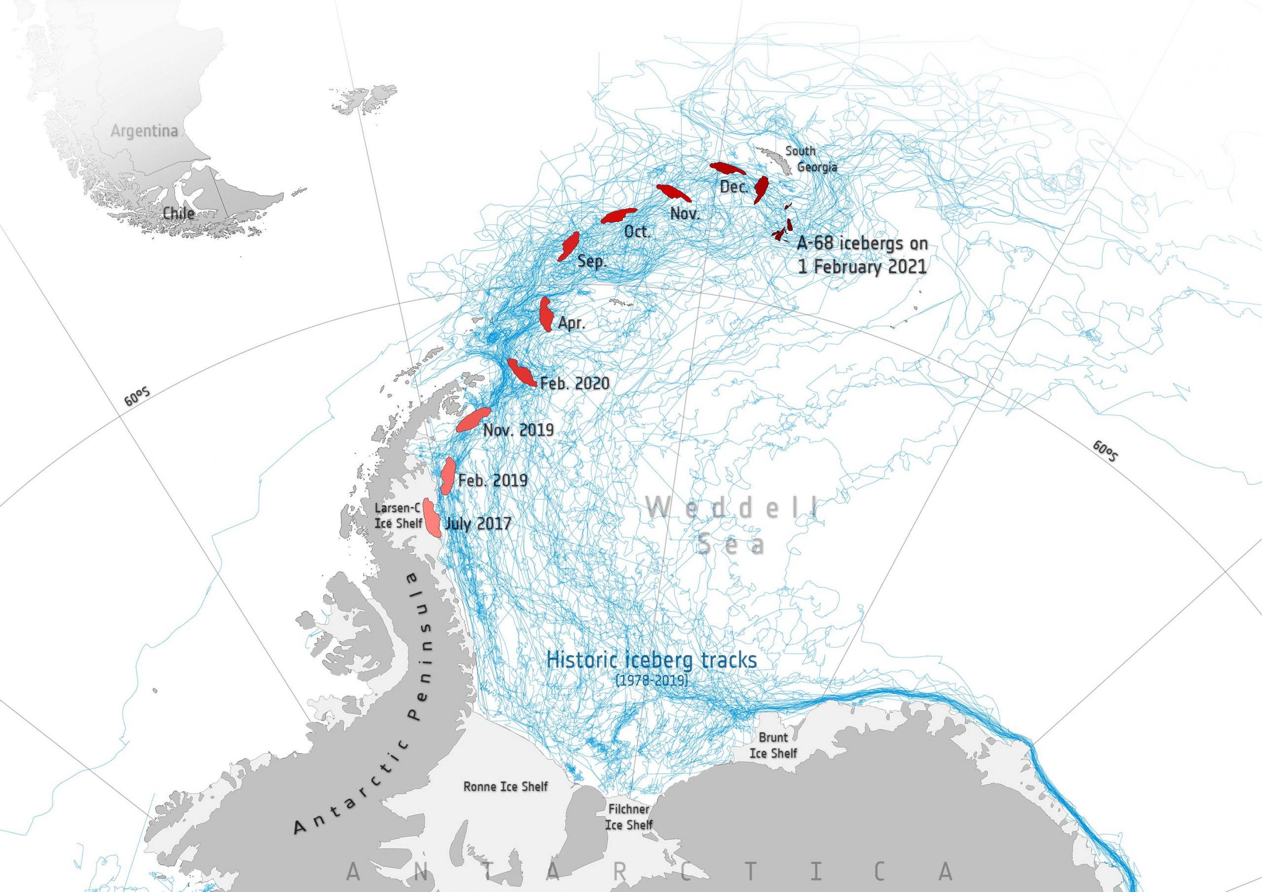
The map below shows the different positions of the berg over the course of its three-year journey. The map highlights that during its first two years of freedom A-68 drifted slowly, impeded by sea ice. But as it moved in relatively open waters, the pace of the iceberg increased significantly. The map also includes historic iceberg tracks, based on data from a number of satellites including ESA’s ERS-1 and ERS-2 as part of the Antarctic Iceberg Tracking Database.
Never miss a breakthrough: Join the SciTechDaily newsletter.
Follow us on Google and Google News.
2 Comments
“Is This the End of One of the Largest Icebergs of All Time?” LOL.
“All time” in this case being about 40 years, i.e. the satellite era.
Does anybody vet this stuff?
Wow, S. Georgia Islands, what a place to live with all the dynamic sea and wind activity.
No wonder the penquins like it.